- Schuylkill River
Geobox River
name = Schuylkill River
native_name =
other_name =
other_name1 =
image_size = 300
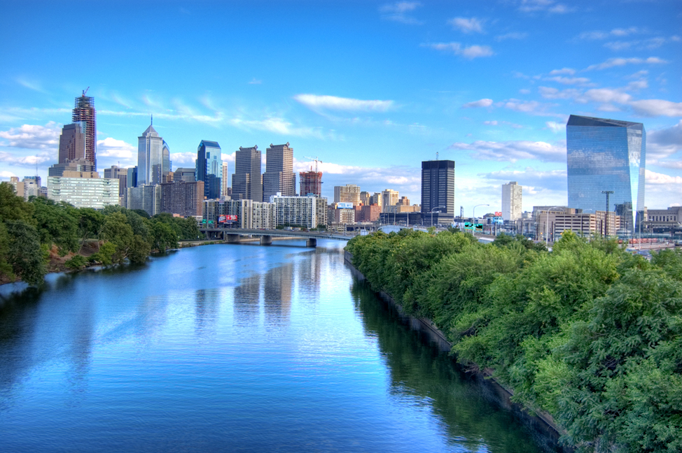
image_caption = The Schuylkill River, looking south toward the skyline ofPhiladelphia , through which the river flows.
country =USA
country1 =
state =Pennsylvania
state1 =
region_type = Counties
region = Philadelphia
region1 = Montgomery
region2 = Chester
region3 = Berks
region4 = Schuylkill
district =
district1 =
city =Philadelphia
city1 = Norristown
city2 = Pottstown
city3 = Reading
length_imperial = 130
watershed_imperial = 2000
discharge_location = Philadelphia
discharge_average_imperial = 4650
discharge_max_imperial = 40300
discharge_min_imperial = 995
discharge1_location = Berne
discharge1_average_imperial = 1120
source_name = East Branch Schuylkill River
source_location = Tuscarora
source_district =
source_region = Schuylkill County
source_state =Pennsylvania
source_country =USA
source_lat_d = 40
source_lat_m = 46
source_lat_s = 24
source_lat_NS = N
source_long_d = 76
source_long_m = 01
source_long_s = 20
source_long_EW = W
source_elevation_imperial = 1540
source_length_imperial =
source1_name = West Branch Schuylkill River
source1_location = Minersville
source1_district =
source1_region = Schuylkill County
source1_state =Pennsylvania
source1_country =USA
source1_lat_d = 40
source1_lat_m = 42
source1_lat_s = 51
source1_lat_NS = N
source1_long_d = 76
source1_long_m = 18
source1_long_s = 46
source1_long_EW = W
source1_elevation_imperial = 1140
source1_length_imperial =
source_confluence_location = Schuylkill Haven
source_confluence_district =
source_confluence_region = Schuylkill County
source_confluence_state =Pennsylvania
source_confluence_country =USA
source_confluence_lat_d = 40
source_confluence_lat_m = 38
source_confluence_lat_s = 01
source_confluence_lat_NS = N
source_confluence_long_d = 76
source_confluence_long_m = 10
source_confluence_long_s = 49
source_confluence_long_EW = W
source_confluence_elevation_imperial = 520
mouth_name =Delaware River
mouth_location =Philadelphia
mouth_district =
mouth_region =
mouth_state =Pennsylvania
mouth_country =USA
mouth_lat_d = 39
mouth_lat_m = 53
mouth_lat_s = 04
mouth_lat_NS = N
mouth_long_d = 75
mouth_long_m = 11
mouth_long_s = 41
mouth_long_EW = W
mouth_elevation_imperial = 0
tributary_left =Little Schuylkill River
tributary_left1 =Perkiomen Creek
tributary_right = Tulpehocken Creek
tributary_right1 = French Creek
free_name =
free_value =

map_size = 300
map_caption = Schuylkill River watershed The Schuylkill River, most often pronEng|ˈskuːkəl ("SKOO-kull"), is a river in the U.S. Commonwealth ofPennsylvania . It is a designated Pennsylvania Scenic River.The
river is about 130mile s (209 km) long. Its watershed of about 2000 square miles (5,000 km²) lies entirely within thestate ofPennsylvania . The source of its eastern branch is in theAppalachian Mountains at Tuscarora Springs, near Tamaqua in Schuylkill County. The west branch starts near Minersville and joins the eastern branch at the town of Schuylkill Haven. The Tulpehocken Creek joins it at the western edge of Reading.Wissahickon Creek joins it in northwestPhiladelphia . Other major tributaries include theLittle Schuylkill River ,Maiden Creek ,Manatawny Creek , French Creek, andPerkiomen Creek . The Schuylkill joins theDelaware River , of which it is the largesttributary , at the site of the formerPhiladelphia Navy Yard , now the Philadelphia Naval Business Center, just northeast ofPhiladelphia International Airport .Major towns and cities on the banks of the river
* Pottsville
* Schuylkill Haven
* Hamburg
* Reading
* Birdsboro
* Bridgeport
* Pottstown
* Royersford
* Spring City
* Phoenixville
* Norristown
* Conshohocken
*Philadelphia The river's history and the etymology of its names
The
Delaware Indians were the original settlers of the area around this river, which they called "Ganshohawanee", meaning "rushing and roaring waters," or "Manaiunk". [cite book |title= Annals of Phoenixville and Its Vicinity: From the Settlement to the Year 1871 |last= Pennypacker |first= Samuel Whitaker |authorlink= Samuel W. Pennypacker |coauthors= |year= 1872 |publisher= Bavis & Pennypacker, printers |location= Phoenixville, PA |isbn= |pages= p. 5] The river was later named "Schuylkill" by its European discoverer,Arendt Corssen of theDutch West India Company . One explanation given for this name is that it translates to "hidden river" and refers to the river's confluence with the Delaware River atLeague Island , which was nearly hidden by densevegetation . Another explanation is that the name properly translates to "hideout creek".Thomas Paine tried in vain to interest the citizens in funding an iron bridge over this river, before abandoning "pontifical works" on account of theFrench revolution .The restoration of the river was funded by money left for that purpose in Benjamin Franklin's will. [cite web |url= http://fi.edu/franklin/family/lastwill.html |title= The Last Will and Testament of Benjamin Franklin |accessdate= 2008-05-31]
Points of interest along the river
* The
Limerick nuclear power plant facility in Limerick
*Valley Forge National Historical Park , site of the winter encampment of the AmericanContinental Army over the winter of1777 –1778 in theAmerican Revolutionary War at the mouth ofValley Creek
*Boathouse Row , a landmark set ofboathouse facilities on Kelly Drive inFairmount Park which houses several local college-affiliated or independent crew teams
* Lemon Hill, a recently restored historic mansion overlookingBoathouse Row
*Fairmount Water Works , a national historic landmark inFairmount Park
*Bartram's Garden
* The formerPhiladelphia Naval Yard , located near the Schuylkill's confluence with the Delaware River.Transportation and recreation in the Schuylkill valley
Transportation
The Schuylkill river valley was an important thoroughfare in the eras of canals and railroads. The river itself, the
Schuylkill Navigation (canal), thePhiladelphia and Reading Railroad (later theReading Railroad ), and thePennsylvania Railroad were vital shipping conduits from the mid-19th century through the mid-20th century.Rail freight still uses many of the same valley rights-of-way that the 19th-century railroads used. Passenger and commuter rail service is more limited. Today, the old railbed rights-of-way along the river between Philadelphia and Norristown contain
SEPTA 's R6 Norristown Regional Rail line (former Reading Railroad right-of-way) and theSchuylkill River Trail (former Pennsylvania Railroad right-of-way).There are efforts to extend both rail and trail farther upriver than they currently reach. The Schuylkill River Trail continues upriver from Norristown to Valley Forge, and designers plan to extend it for scores of miles farther upriver. SEPTA Regional Rail service currently does not go farther upriver than Norristown. Visions of
commuter rail service farther up the Schuylkill valley ("Schuylkill Valley Metro ") have yet to become reality.Roads associated with the river include the
Schuylkill Expressway , the West Shore Bypass (on the west bank), theKelly Drive (on the east bank, so also called the East River Drive), and the Martin Luther King, Jr. Drive (on the west bank, so also called the West River Drive).Recreation
The
Schuylkill River Trail , [ [http://www.montcopa.org/parks/schuylkillrivertrail.htm] Dead link|date=March 2008] which generally follows the river bank, is a multi-use trail for walking, jogging, bicycling, rollerblading, and other outdoor activities. The trail presently runs from Philadelphia to thePerkiomen Creek , just beyond Valley Forge Park. There is also a section of trail starting at Pottstown and running upriver. Plans are underway to develop the trail between the existing sections.The Schuylkill River is very popular with watersports enthusiasts. The
Dad Vail Regatta , an annual rowing competition, is held on the river nearBoathouse Row , as is the annual Bayada Regatta, featuring disabled rowers from all over the continent.ee also
*
List of cities and towns along the Schuylkill River
*List of crossings of the Schuylkill River
*List of Pennsylvania rivers
* [http://www.schuylkillriver.org/ Schuylkill River Heritage Area]References
External links
* [http://waterdata.usgs.gov/pa/nwis/current/?type=flow U.S. Geological Survey: PA stream gaging stations]
* [http://www.phillyrivercast.org/ Philly RiverCast]
* [http://newweb.erh.noaa.gov/ahps2/hydrograph.php?wfo=phi&gage=PADP1 Advanced Hydrologic Prediction Service: Schuylkill River at Philadelphia]
* [http://www.schuylkillplan.org/ Schuylkill Watershed Conservation Plan]
* [http://www.schuylkillriver.org Schuylkill River National & State Heritage Area]
* [http://www.state.nj.us/drbc/schuylkillmaps.htm Delaware River Basin Commission Schuylkill River Maps]
* [http://abclocal.go.com/wpvi/index?section=news&id=4604703 Channel 6 Action News report: The Search for the Source of the Schuylkill River]
* [http://www.delawareriverkeeper.org/about_schuylkill.html History]
* [http://www.schuylkillchamber.com/history.htm Ganshohawanee, meaning rushing and roaring waters, later called Schulen-kill, or as it is pronounced today, Schuylkill, “school kill.” The Schuylkill Chamber of Commerce]
* [http://www.brynmawr.edu/iconog/schwarz/63-07.jpgArt by Thomas Birch (American, born England, 1779-1851), "View of the Chain Bridge and Falls of Schuylkill, Five Miles from Philadelphia"]
* [http://www.brynmawr.edu/iconog/schwarz/58-29.jpgArt by Titian Ramsay Peale (American, 1799-1885), "The Schuylkill River above Philadelphia", 1881]
* [http://www.brynmawr.edu/iconog/HSP/19133.jpgArt by William Groombridge, "Fairmount and Schuylkill River", 1800]
* [http://www.phillyh2o.org/backpages/Schuylkill_Views.htm Schuylkill River views]
Wikimedia Foundation. 2010.