- Melton, Victoria
-
Melton
Victoria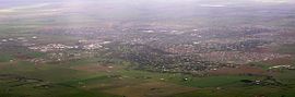
Aerial view of Melton urban area
 Melton
Population: 35,490(2006) [1] Established: 1862 Postcode: 3337-3338 Area: 25.2 km² (9.7 sq mi) Location: 35 km (22 mi) from Melbourne LGA: Shire of Melton State District: Melton Federal Division: Lalor Localities around Melton: Melton West Kurunjang Toolern Vale Melton West Melton Plumpton Brookfield Melton South Melton South - For other uses of the term Melton, see Melton (disambiguation).
Melton is an outer-suburban city of Melbourne Victoria, Australia located 35 km east from Melbourne's central business district. It is the administrative centre for the Shire of Melton Local Government Area. At the 2006 Census, the Shire of Melton had a population of 35,490. Melton is part of Melbourne's population statistical division,[2] meaning that it is considered part of Greater Melbourne.
Melton began as a small town before being declared a satellite city in 1974, separated from Melbourne's urban area by a green wedge. Since the 1990s it experienced rapid suburban growth into surrounding greenfield land and become a commuter town in the Melbourne-Ballarat. Changes to Melbourne's urban growth boundary passed by the state government in 2010 effectively relinquish its satellite city status as it is planned to become part of Melbourne's future metropolitan conurbation.[3]
It is named after Melton Mowbray in the United Kingdom.
Contents
History
Melton was first settled by squatters establishing sheep runs in the area in the 1830s and a small settlement benefited from traffic passing through it on the way to the Ballarat gold fields during the Victorian Gold Rush. The Post Office opened on 1 March 1856.[4]
The area was declared a satellite city in 1974 and a green belt existed between it and the urban area of Melbourne until the late 1990s.
Geography
Melton is located on flat, formerly volcanic plains.
Urban Structure
Melton consists of 6 suburban areas forming a single urban area with Melton being at its centre. In the south of Melton are the suburbs of Melton South and Brookfield. In the north are Kurunjang and Toolern Vale. Melton West is another suburb.
Arts and Culture
 Community Hall
 Djerriwarrh Festival parade
Many live performances are held at the Melton Civic Centre, on High Street, and also at the Tabcorp Park racing complex, on Ferris Road, Melton South.
And every year, the Djerriwarrh Festival is held in the city each November. The festival includes a street parade down High Street, two-day market stalls, and the Lions Club Carnival, held in the Police Paddock on High Street.
Sport
Melton is the home of the harness racing complex Tabcorp Park, and is the base for Harness Racing Victoria. The 2009 Australasian Breeders Crown was the first major race meeting held at the venue in August 2009.
Melton is also home to the second round of the Continental Australian Superboat Championship, and the 2009 World Series of the V8 Jetboats. Both events are held at the Melton Jetboat Complex at MacPherson Park, about 7 km north of the Melton CBD.
Governance
 Shire of Melton offices
Melton is the administrative centre for the Shire of Melton. The Shire of Melton's Coburn Ward covers the central Melton area.
Its state government electorate is the Electoral district of Melton and the Federal government electorate is the Lalor, the seat of Julia Gillard both considered safe Australian Labor Party seats.
Media
All areas of Melton receive the same analogue and digital television stations as Melbourne. It is also within in the broadcast range of all commercial radio stations from Melbourne, and is an end point for digital radio broadcasts in metropolitan Melbourne. Digital radio is available in most of the city but signal diminishes towards the West.
Melton has two local newspapers - The Melton Leader and Melton Weekly.
The city is also home to a radio station, 979fm.
Infrastructure
Transport
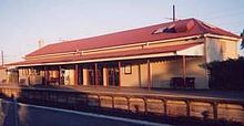 Melton railway station
The main form of transportation in Melton is the automobile. Melton has been identified by the Department of Transport as one of the most car-dependent communities in Greater Melbourne.[5] As such Melton has a substantial network of busy roads. The Western Freeway connects Melton with Melbourne's west runs through the urban area to the south, but bypasses the city centre which is located along High Street, a very wide dual carriageway with service lanes. There are two major freeway interchanges in the urban area, one for Coburns Road which is the main north-south arterial and another for the Melton Highway (C754), an alternative route to the northern suburbs of Melbourne and branches north to the Melton-Gisborne Road (C705) at Kurrunjang connecting Melton to Gisborne.
Melton railway station (located in Melton South) is on the Ballarat railway line. V/Line provides VLocity passenger train services run to and from Southern Cross Station (journey time of between 27–48 minutes). Although specifically mentioned in the Victorian Transport Plan, the government is yet to commit to a project plan for railway electrification system to Melton [6] despite strong local lobby for it.[7] The railway station is a very popular park and ride locality, however it has been criticised due to notoriously poor parking infrasture.[8]
Buses service running between 5:30am-9pm on weekdays and 8am-9pm on weekends connect the city's suburbs to the railway station and also Melbourne's outer suburbs including the 456 to Sunshine via Caroline Springs; 457 from Melton West to the railway station; 458 Kurrunjang to the railway station; and 459 Arnolds Creek to the railway station via Westlake. A shuttle service also provides services to Melbourne Airport.
Melton Airfield, located to the north in Toolern Vale provides general aviation.
Education
Melton has several primary and secondary schools.
Primary Schools
- Melton Primary School - Unitt Street, City.
- St. Dominic's Catholic Primary School - Unitt Street, City.
- Wedge Park Primary School - Cambrian Way, West Melton.
- St. Catherine of Siena Primary School - Bulmans Road, Melton West.
- St. Anthony of Padua Primary School - Wilson Road, Melton South.
- Melton South Primary School - Station Road, Melton South.
- Melton West Primary School - West Melton Drive, Melton West
- Coburn Primary School- Richards Road, Melton South
- Mowbray College
- Exford Primary School
- Kurunjang Primary school
Secondary Schools
- Kurunjang Secondary College - Kurunjang Drive, Kurunjang.
- Melton Secondary College - Cnr. Coburns Rd. and High Streets, Melton West.
- Catholic Regional College - Bulmans Road, Melton West.
- Mowbray College - Centenary Avenue, Melton North.
- Staughton College (Formerly Wilson Park Secondary College) - Wilson Road, Melton South.
- Melton Christian College - Brooklyn Road, Melton South
References
- ^ Australian Bureau of Statistics (25 October 2007). "Melton (Urban Centre/Locality)". 2006 Census QuickStats. http://www.censusdata.abs.gov.au/ABSNavigation/prenav/LocationSearch?collection=Census&period=2006&areacode=UCL232400&producttype=QuickStats&breadcrumb=PL&action=401. Retrieved 2007-10-25.
- ^ http://www.vcec.vic.gov.au/CA256EAF001C7B21/WebObj/MelbourneSD/$File/Melbourne%20SD.pdf Melbourne Statistical Division
- ^ http://www.melton.vic.gov.au/Page/Page.asp?Page_Id=1526&h=1
- ^ Premier Postal History. "Post Office List". https://www.premierpostal.com/cgi-bin/wsProd.sh/Viewpocdwrapper.p?SortBy=VIC&country=. Retrieved 2008-04-11.
- ^ http://www.transport.vic.gov.au/DOI/DOIElect.nsf/$UNIDS+for+Web+Display/2F39BE88F87138ECCA2577C3000DB4EA/$FILE/IA-2009-MeltonDuplicationandElectrification-Stages1-6.pdf
- ^ http://www.vline.com.au/about/vtp/victoriantransportplan.html
- ^ http://mps.vic.greens.org.au/electrifymeltonline
- ^ Macleer, Liam Melton Railway Station suffers: MP Melton Leader 20th October 2010
Toolern Vale and District Primary School - Creamery Rd., Toolen Vale, 3337
External links
Suburbs of the Shire of Melton Brookfield · Burnside · Burnside Heights · Caroline Springs · Diggers Rest · Exford · Eynesbury •
Hillside · Kurunjang · Melton · Melton South · Melton West · Mount Cottrell · Parwan • Plumpton · Ravenhall · Rockbank · Taylors Hill · Toolern Vale · TruganinaCities of Victoria, Australia Regional VictoriaArarat · Bairnsdale · Ballarat · Benalla · Bendigo · Castlemaine · Colac · Echuca · Geelong · Hamilton · Horsham · Maryborough · Mildura · Moe · Morwell · Portland · Sale · Shepparton · Swan Hill · Traralgon · Wangaratta · Warrnambool · WodongaList of Melbourne suburbs · List of localities in Victoria Categories:- Towns in Victoria (Australia)


Wikimedia Foundation. 2010.