- Bayshore Freeway
Infobox road
state=CA
marker_
highway_name=Bayshore Freeway
alternate_name=
maint=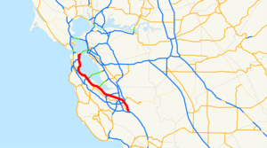
length_mi=56.4
length_round=1
length_ref=Google Maps [http://maps.google.com/maps?f=d&hl=en&geocode=2724768865386941287,37.257264,-121.796158&saddr=US-101+N+%4037.257264,+-121.796158&daddr=37.786449,-122.390356&mra=mi&mrsp=1,0&sz=18&sll=37.786699,-122.390029&sspn=0.002963,0.005643&ie=UTF8&ll=37.538044,-122.008667&spn=0.761168,1.444702&z=10 driving directions] , accessed February 2008]
direction_a=South
terminus_a=jct|state=CA|US|101|SR|82 in San Jose
junction=jct|state=CA|SR|85 in Mountain View
jct|state=CA|SR|84 in Redwood City
jct|state=CA|SR|92 in San Mateo
direction_b=North
terminus_b=jct|state=CA|I|80 in San FranciscoThe Bayshore Freeway is a major part of U.S. Route 101 in theSan Francisco Bay Area of theU.S. state ofCalifornia . It runs along the west shore of theSan Francisco Bay , connecting San Jose with San Francisco. Within the city of San Francisco, the freeway is also known as part of the James Lick Freeway. The road was originally built as a surface road, the Bayshore Highway, and later upgraded tofreeway standards. Before 1964, it was mostly marked as U.S. Route 101 Bypass, with US 101 using the present State Route 82 (El Camino Real).Route description
The Bayshore Freeway begins at the Blossom Hill Road interchange on US 101, where SR 82 begins its northwesterly path along Monterey Highway to San Jose. The freeway curves north and northwest, bypassing downtown San Jose to the east, and then curves west-northwest, crossing I-880 and SR 87, the latter just north of the
San Jose International Airport . The portion of the highway from San Jose to South San Francisco is relatively straight and flat, running near the west edge of theSan Francisco Bay . Junctions here include SR 237 in Sunnyvale, SR 85 in Mountain View, SR 84 in Menlo Park and Redwood City, SR 92 in San Mateo, and theSan Francisco International Airport and I-380 in San Bruno. In South San Francisco, the freeway curves northeast aroundSan Bruno Mountain , crossing its east edge at Sierra Point, and then heads north on acauseway across the formerCandlestick Cove to the San Francisco city line.Google Maps street maps andUSGS topographic map s, accessed January 2008 via [http://mapper.acme.com/ ACME Mapper] ]In San Francisco, where the road is also known as the James Lick Freeway, it continues north-northwesterly between
Bayview Park andMcLaren Park , and crosses I-280 at theAlemany Maze . There it curves north-northeasterly aroundBernal Heights and then northwest aroundPotrero Hill , meeting theCentral Freeway at the border between theMission District andSouth of Market . The Bayshore Freeway ends at the intersection of US 101 andInterstate 80 [http://www.dot.ca.gov/hq/tsip/hseb/products/Named_Freeways.pdf]History
Initial construction: Bayshore Highway
Before the Dumbarton and
San Mateo-Hayward Bridge s were built across theSan Francisco Bay in the 1920s, San Francisco was bottled up at the north end of a long peninsula, with driving south on El Camino Real towards San Jose as the only reasonable alternative to theferries for crossing the bay. The first of several highways built as an alternate to El Camino Real was theSkyline Boulevard , which was added to the state highway system in 1919. A second route, the Bay Shore Highway (Route 68 [cite CAstat|year=1935|ch=29|p=280: "Route 68 is the Bay Shore Highway from San Francisco to San Jose. This route includes the San Francisco – Oakland Bay Bridge and the approaches thereto on the San Francisco end..."] ), became a state highway in 1923, but only from the San Francisco city limits into San Mateo County, where the Dumbarton Bridge would begin. [cite CAstat|year=1923|ch=181|p=422: "from the county line separating the city and county of San Francisco from the county of San Mateo, in, to and through the county of San Mateo, at such location or locations as the said California highway commission may select."] Just prior to the start of construction on the Dumbarton Bridge, San Francisco SupervisorRichard J. Welch noted that the Bay Shore Highway would need to be built all the way to San Jose as an escape valve for the additional traffic that the bridge would attract.Mel Scott, The San Francisco Bay Area: A Metropolis in Perspective,University of California Press , 1959, pp. 174, 183, 209-210, 215]The state legislature extended the highway in 1925, defining it to run from near the intersection of Army Street (
Cesar Chavez Street ) and San Bruno Avenue in San Francisco to a point in San Jose. The governor approved the bill with the stipulation that only the portion between the city limits of San Francisco and San Jose would be a state highway. [cite CAstat|year=1925|ch=471|p=1009] Construction between South San Francisco and Burlingame had begun by 1924, funded by a $500,000 contribution from San Francisco, and was completed in 1928. A disconnected segment north of San Mateo was built by the state at the same time. It was not until February 1929 that the road was fully paved between San Francisco and Burlingame, and onOctober 20 ,1929 the new highway was officially dedicated to San Mateo, [Los Angeles Times , Desert Replaces Ocean and Mountains in Hearts of Those Who Roam in Motor Cars,October 20 ,1929 , p. 1] Lawrence Kinnaird, History of the Greater San Francisco Bay Region,Lewis Historical Publishing Company , 1966, pp. 243-245] several months after the connecting San Mateo-Hayward Bridge opened (at what is now Third Avenue [Rand McNally & Company , [http://members.cox.net/mkpl2/hist/droz-sfca33n.jpgsan Francisco & Vicinity] , 1933] ). [New York Times , Coolidge Opens Big Bridge,March 3 ,1929 , p. N4] Even then, motorists had to wait untilMay 7 ,1931 to reach Jefferson Avenue in Redwood City (near the west end of the four-year-old Dumbarton Bridge). [Oakland Tribune , Bayshore Highway Open to Palo Alto,May 10 ,1931 ] The roadway was extended to Oregon Avenue in Palo Alto in mid-1932, [San Mateo Times ,October 7 , , [http://www.dot.ca.gov/hq/traffops/hwybrdg/tollbridge/History/Dumbarton.html Dumbarton Bridge] , accessed February 2008] Although the highway was designed and built to what were, at the time, high standards, with a 100-foot (30 m) wideright-of-way in most places, it was accident-prone because it lacked amedian barrier . One segment of the so-called "Bloody Bayshore" was "Boneyard Hill", a steep grade through theVisitacion Valley near the San Francisco city line, running past abone meal plant. Causes of the crashes included turning conflicts at intersections, andspeeding drivers crossing thecenterline to use the oncoming lanes as apassing lane . [Paul D. Buchanan,San Mateo Daily Journal , History traces the bayshore from highway to freeway,April 15 ,2002 ] Matt Bowling,Palo Alto Daily News , [http://www.paloaltodailynews.com/article/2007-5-20-pa-then-and-now Then and Now: The 'Bloody Bayshore'] ,May 20 ,2007 ] The roadway was entirely at-grade except for crossings ofrail line s. It generally followed the present alignment of the Bayshore Freeway, but deviated in several places: Old Bayshore Highway in San Jose, Veterans Boulevard in Redwood City, Bayshore Highway in Burlingame, a destroyed section of road throughSan Francisco International Airport , and Airport and Bayshore Boulevards from South San Francisco through Brisbane into San Francisco. Within that city, the new highway continued three miles (5 km) along the present Bay Shore Boulevard to Army (Cesar Chavez) Street and Potrero Avenue.United States Geological Survey , [http://sunsite2.berkeley.edu/lizardtech/iserv/calcrgn?cat=histopo&item=brk00000128_10a.sid&wid=600&hei=500&style=generic/view.xsl&plugin=true San Jose (1942)] , [http://sunsite2.berkeley.edu/lizardtech/iserv/calcrgn?cat=histopo&item=brk00000105_10a.sid&wid=600&hei=500&style=generic/view.xsl&plugin=true Palo Alto (1940)] , [http://sunsite2.berkeley.edu/lizardtech/iserv/calcrgn?cat=histopo&item=brk00000074_10a.sid&wid=600&hei=500&style=generic/view.xsl&plugin=true Hayward (1942)] , [http://sunsite2.berkeley.edu/lizardtech/iserv/calcrgn?cat=histopo&item=brk00000137_10a.sid&wid=600&hei=500&style=generic/view.xsl&plugin=true San Mateo (1939)] , and [http://sunsite2.berkeley.edu/lizardtech/iserv/calcrgn?cat=histopo&item=brk00000024_10a.sid&wid=600&hei=500&style=generic/view.xsl&plugin=true San Francisco (1942)] (scale 1:62500)]When the Bayshore Highway was completed in 1937, U.S. Route 101 signs were moved to it from El Camino Real, and El Camino became U.S. Route 101 Alternate. Businesses along El Camino created the El Camino Real Association to protest the move and resulting loss of business, [
San Mateo Times , Camino Robbed of Auto Traffic by Plot, Claim,December 23 ,1937 ] and by 1939 the main route had been moved back, with the Bayshore Highway becoming U.S. Route 101 Bypass. [Oakland Tribune ,October 1 , , [http://cahighways.org/maps/1963sf.jpgSan Francisco] , 1963]Construction of an extension to Route 115 (Santa Clara Street, now SR 130) at 30th Street in San Jose began in 1939, [
Oakland Tribune , To Extend Bayshore,March 19 ,1939 ] [Oakland Tribune ,April 16 ,1939 : "Bids will be opened at Sacramento, April 5 for two bridges on the projected extension of the Bayshore Highway to 30th and East Santa Clara Streets..."] and was completed by late 1940. [Oakland Tribune ,November 23 ,1940 : "Autos driven by Dowey and Joseph Lawrence, Evergreen rancher, collided at McKee Road and Bayshore Highway."] As with the portion between Fourth and 13th Streets, it was not marked as a numbered route. The state legislature authorized an extension beyond San Jose back to El Camino Real near Ford Road in 1947,cite CAstat|year=1947|ch=1233|p=2736: "Route 68 is the Bayshore Highway from San Francisco to Route 2 near Ford Road south of San Jose."] which was already under construction, and was completed that year.California Department of Transportation , [http://www.dot.ca.gov/ser/downloads/cultural/CalHwyIndex.pdf Index to California Highways and Public Works] , 1937-1967, June 1997, pp. 104, 107, 109] This was the first segment built with interchanges, and included amedian barrier . Despite this, most crossings were at-grade; only the two ends at Route 115 (Santa Clara Street) and regular US 101 included bridges, the former adiamond interchange and the latter a simple split with additional access to Ford Road. It also crossed over Coyote Road, though with no access, just south of theCoyote Creek bridge. [United States Geological Survey , [http://sunsite2.berkeley.edu/lizardtech/iserv/calcrgn?cat=histopo&item=brk00000131_10a.sid&wid=600&hei=500&style=generic/view.xsl&plugin=true San Jose (scale 1:62500)] , 1953] The original 1947 bridge over Coyote Road remains, though widened in 1990, and is one of the oldest road-roadgrade separation s on the present freeway.Reconstruction: Bayshore Freeway
By 1940, at the dawn of the
freeway era, the state was making plans to convert the Bayshore Highway into a ten-lane Bayshore Freeway between San Francisco and Palo Alto. [Oakland Tribune , Bayshore Speed Road Discussed,July 26 ,1940 ] The first piece built was from Peninsula Avenue at the San Mateo-Burlingame line to South San Francisco. This six-lane freeway, completed in 1949 , followed the existing highway to Broadway in Burlingame, but then took a more inland alignment past theSan Francisco International Airport , and crossed the old road at South San Francisco, running just east of it to near the south end of the cut at Sierra Point. [United States Geological Survey , [http://sunsite2.berkeley.edu/lizardtech/iserv/calcrgn?cat=histopo&item=brk00000323_10a.sid&wid=600&hei=500&style=generic/view.xsl&plugin=true San Mateo (1949)] , [http://sunsite2.berkeley.edu/lizardtech/iserv/calcrgn?cat=histopo&item=brk00000320_10a.sid&wid=600&hei=500&style=generic/view.xsl&plugin=true Montara Mountain (1949)] , and [http://sunsite2.berkeley.edu/lizardtech/iserv/calcrgn?cat=histopo&item=brk00000313_10a.sid&wid=600&hei=500&style=generic/view.xsl&plugin=true San Francisco South (1947)] (scale 1:24000)] Construction began inside San Francisco in 1950 and was completed in 1958; the newcauseway acrossCandlestick Cove , connecting the completed section in South San Francisco with San Francisco, was dedicated in mid-1957. In 1951, the state legislature renamed the portion within San Francisco afterJames Lick , a California pioneer and philanthropist. [cite CAstat|year=1951|res=yes|ch=122|p=4550]A movement to make the four-lane undivided "Bloody Bayshore" safer all the way to San Jose began in Palo Alto. As a temporary measure, the state lowered the
speed limit , installedtraffic signal s, closed minor crossroads, and prohibited left turns in places. The community convinced the state to extend the six-lane freeway,MPO Productions , [http://www.archive.org/details/Freedomo1955 Freedom of the American Road] , 1955] which was completed in 1962. The freeway continued to end at the old El Camino Real merge near Ford Road until the early 1980s, when theSouth Valley Freeway was constructed.Exit list
:"Note: Except where prefixed with a letter,
postmile s were measured in 1964, based on the alignment as it existed at that time, and do not necessarily reflect current mileage. The numbers reset at county lines; the start and end postmiles in each county are given in the county column."References

Wikimedia Foundation. 2010.