- Patras
Infobox Greek Dimos
name = Patras
name_local = Πάτρα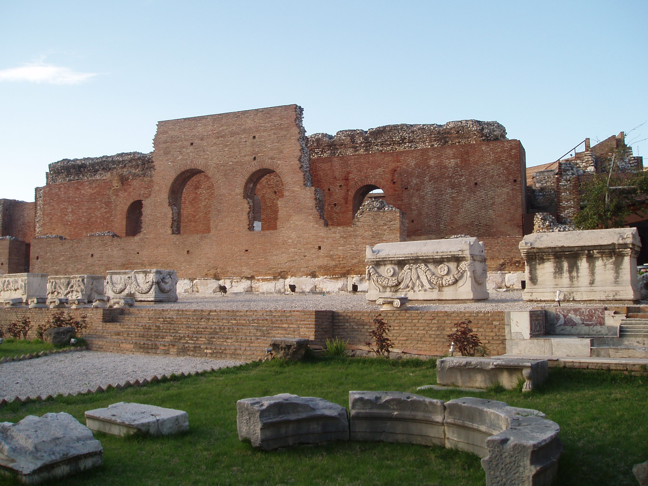
caption_skyline = the Roman Odeum of Patras
city_
city_
districts = 11
party =
since =
periph =West Greece
prefec =Achaea
population = 171616
population_metro = 210494
population_as_of = 2001
area = 125.4
area_metro =
elevation_min = 0
elevation_max = 10
lat_deg = 38
lat_min = 15
lon_deg = 21
lon_min = 44
postal_code = 26x xx
area_code = 2610
licence = ΑΧ,AZ
mayor = Andreas Fouras
website = [http://www.patras.gr www.patras.gr]Patras (
Demotic Greek : Πάτρα, "Pátra", IPA2|ˈpatra,Classical Greek : Πάτραι, "Pátrai", _la. Patrae) isGreece 's third largest urban centre and the capital of the prefecture ofAchaea , located in northernPeloponnese , 215 kilometers west of Athens. The city is built at the foothills of MountPanachaikon , overlooking theGulf of Patras .The Patras metropolitan area is a conurbation of nearly 200,000 inhabitants.cite web|url =http://www.urbanaudit.org/CityProfiles.aspx| title =EU Commission, Directorate General for Regional Policy, Inforegio, Urban Audit, City profile] The core settlement has a history spanning four millennia. In the Roman period it had become a cosmopolitan centre of the eastern
Mediterranean whilst, according to Christian tradition, it was also the place of Saint Andrew'smartyr dom. Dubbed Greece's "Gate to the West", Patras is a commercial hub, while its busy port is a nodal point for trade and communication withItaly and the rest ofWestern Europe . The city has two public universities and one Technological Institute, hosting a large student population and rendering Patras a major scientific centre with a field of excellence in technological education. TheRio-Antirio bridge connects Patras' easternmost suburb of Rio to the town of Antirrio, connecting the Peloponnese peninsula with mainland Greece. Every spring, the city hosts one of Europe's largest and most colourful carnivals; notable features of thePatras Carnival include its mammoth-sized satirical floats and extravagant balls and parades, enjoyed by hundreds of thousands of visitors in a pleasantMediterranean climate , with relatively cool yet humid summers and rather mild winters. Patras is also famous for supporting an indigenous cultural scene active mainly in the performing arts and modern urban literature; it wasEuropean Capital of Culture 2006.Geography and climate
Patras is located convert|215|km|mi|0|abbr=on west of Athens by road, convert|94|km|mi|0|abbr=on northeast of Pyrgos, convert|7|km|mi|0|abbr=on south of Rio, convert|134|km|mi|0|abbr=on west of Corinth, 77 kilometers northwest of
Kalavryta , and convert|144|km|mi|0|abbr=on northwest of Tripoli.A central feature of the
urban geography of Patras is its division in upper and lower sections, connected with stairs. This is the result of an interplay between natural geography and human settlement patterns; the lower section of the city, which includes the 19th century urban core and the port, is adjacent to the sea and stretches between the estuaries of the rivers of Glafkos and Haradros. It is built on what was originally a bed of river soils and dried-up swamps. The older upper section covers the area of the pre-modern settlement, around the Fortress, on what is the last elevation of Mount Panachaikon (convert|1926|m|ft|0|abbr=on) [http://www.ditikiellada-region.com/en_contents.asp?id=92 Region of Western Greece: Geography] - Accessed Feb. 9, 2007] before the Gulf of Patras.The largest river in the area is
Glafkos flowing to the south of Patras. Glafkos springs in MountPanachaikon and its water is, since 1925, collected in a small mountainous reservoir-dam near the village of Souli and subsequently pumped in order to provide energy for the country's firsthydroelectric plant . [Thomopoulos, St. N, "History of the City of Patras from Antiquity to 1821", Patrai 1952, (ed. Triantafyllou, K.N.)] The water is also used for the orchards of Eglykas and as drinking water for the city. Other rivers are "Haradros", "Meilichos" and the mountain torrent "Diakoniaris".climate chart
Patras
6.1|14.5|89
6.4|15|82
7.7|16.8|63
10.2|19.7|48
13.9|24.2|29
17.4|28|8
19.4|30.1|5
19.6|30.9|5
17.2|28.2|28
13.8|24.1|72
10.3|19.5|118
7.6|16.1|116
source=HNMS (ΕΜΥ)cite web|url= http://www.hnms.gr/hnms/greek/climatology/climatology_region_diagrams_html?dr_city=Patra
title=Patras climatology data |work=EMY]
float=rightOf great importance for the biological diversity of the area and the preservation of its climate is the swamp of
Agyia , a small and coastalaquatic ecosystem of only 30 hectares, located to the north of the city centre. The main features of this wetland are its apparent survival difficulty, being at the heart of a densely populated urban centre that features a relatively arid climate and its admittedly high level of biodiversity, with over 90 species of birds being observed until the early 1990s, according to a study by the Patras Bureau of the "Hellenic Ornithological Society". [ [http://www.ornithologiki.gr/en/enmain.htm Hellenic Ornithological Society - Birds, birding and conservation in Greece ] ]Another geophysical characteristic of the region is its high level of
seismicity . Small tremors are recorded along the coast of Patras almost constantly. Larger earthquakes hit the area every few years with potentially destructive effects. In 1993, a 5.0 magnitude earthquake caused some damage to several (mostly older) buildings throughout Patras due to the proximity of the epicenter to the city. In June 15, 1995, a 6.2 magnitude earthquake hit the nearby town ofAigion , causing some structural damage to a few buildings of Patras as well. The Ionian Islands are also frequently hit by even more severe earthquakes, some of which can be felt in the city. In antiquity, the most notable example of destruction caused by an earthquake in the region was the total submergence of the ancient Achaean city ofHelike , nowEliki .History
The first traces of settlement in Patras date as early as in the 3rd millennium BC, in the area of modern Aroe. Patras flourished for the first time during the Post-Helladic or Mycenean period (1580–1100 BC). Ancient Patras was formed by the unification of three Mycenaean villages located in modern Aroe; namely Antheia and
Mesatis . Mythology has it that after the Dorian invasion, a group ofAchaeans fromLaconia led by thePatreus established a colony. During antiquity, Patras remained a farming city. It would be in Roman times that it was to become an important port.After 280 BC and prior to the Roman occupation of Greece, Patras played a significant role in the foundation of the second "
Achaean League " (Achaiki Sympoliteia), along with the cities of Dyme, Triteia and Pharai. Later on, and following the Roman occupation of Greece in 146 BC, Patras played a key role, andAugustus founded a Roman colony in its area. Moreover, Patras became a Christian centre since the early days of Christianity, and it is the city where St. Andrew was crucified.During Byzantine times Patras continued to be an important port as well as an industrial centre. One of the most scholarly philosophers and theologians of the time,
Arethas of Caesarea was born at Patrae, at around 860. By the 9th century there are strong signs the city was prosperous: the widowDanielis from Patras had accumulated immense wealth in land ownership, the carpet and textile industry, and offered critical support in the ascent ofBasil I the Macedonian to the Byzantine throne.In 1204 Patras was conquered by the
Fourth Crusade , and became the seat of the LatinDuchy of Athens within thePrincipality of Achaea . Captured in 1205 byWilliam of Champlitte andVillehardouin , the city became capital and its archbishop primate of the principality of Achaea, while in 1387Juan Fernández de Heredia , grand master of the order of the Knights Hospitaller atRhodes , endeavoured to make himself master of Achaea and took Patras by storm. In 1408, Patras became Venetian, and by the close of the 15th century the city was governed by the archbishop in the name of thepope . It was nevertheless seized once more by the despot Constantine in 1430, who was immediately contested by theOttoman Empire .In 1458 Patras was conquered by the Sultan of the
Ottoman Empire ,Mehmet II . Under the Ottomans, it was known as Baliabadra, from the Greek Παλαιά Πάτρα, the town, as opposed to Νέα Πάτρα, the fortress. Though Mehmet granted the city special privileges and tax reductions, it never became a major centre of commerce.Venice andGenoa attacked and captured it several times during the 15th and 16th centuries, but never re-established their rule effectively. [Encyclopaedia of Islam "s.v." Baliabadra] . It was here that theGreek Revolution began [Strategus Makrygiannis, "Memoirs", Book A, Chapter I, Athens, 1849, http://www.snhell.gr/testimonies/writer.asp?id=102] ; but the Turks, confined to the citadel, held out until 1828.Patras was liberated on 7 October, 1828 by the French expeditionary force in the Peloponnese, under the command of General Maison. Patras developed quickly into the second largest urban centre in late 19th century Greece. [Triantafyllou, Κ.Ν., "Historic Lexicon of Patras"] The city benefited from its role as the main export port for the agricultural produce of the Peloponnese. [Kounenaki Pegy, "19th Century Patras: how the character of the city changed with the development of the port after 1828" "Kathimerini" 14-10-01 http://news.kathimerini.gr/4dcgi/_w_articles_civ_491371_14/10/2001_3252]
In the early 20th century, Patras developed fast and became the first Greek city to introduce public streetlights and electrified tramways. [Thomopoulos] The war effort necessitated by the
first World War hampered the city's development and also created uncontrollableurban sprawl with the influx of refugees fromAsia Minor . During the Second World War, the city was a major target of Italian air raids; during the period of Axis occupation, a German military command was established and German and Italian troops stationed in the city.Urban landscape
The city is divided into the upper and the lower sections, connected with roads and broad stairs. The upper section is the older and the more picturesque; however, the lower sections are attractively laid out, featuring a variety of squares in a unique geometric pattern. The most notable of these are the "Psila Alonia" and the "Georgiou I" . A number of exquisite neoclassical buildings are to be found, including the "" "Apollon" Theatre" in Georgiou I Square, the "Town Hall", the headquarters of the "Local Trade Association" and the " Court of Justice".
The most significant ancient monument, open to the public, is the "Roman Odeon", now reconstructed and in use as an open-air theatre used for performances and concerts during the summer months. Overlooking the whole town is the ruined "Castle", whose current outline dates back to the Venetian invasion of the town (1687-1715). Today, its interior is used as a public garden.
Near the seafront, between the sites of the new and the old port, stands the monumental church of Saint Andrew, the patron Saint of the city and the largest church of Greece.cite web|url=http://www.infocenterpatras.gr/mnimeia_en.php|title=Info about St.Andrew Church by InfoCenter Patras] A replica of the city's emblematic old lighthouse, built as a part of a coastline beautification project, rises at a nearby park. In general, much of Patras' coastline is framed by roads and avenues running alongside; these include " Dymaion Coast" to the south and "Iroon Polytechneiou Road" to the north. Unfortunately, due to insufficient urban planning as well as institutional weaknesses on behalf of the City Council (mainly due to a lack of proper financial planning), some of the city's coastal areas are not in an ideal condition, with several areas illegally occupied by shops built along the coastline. This is contrary to what the
Constitution of Greece of 2001 declares; that the Greek coastline is a "national treasure", and as such belongs to the Greek people.Architecture
The city is endowed with a number of neoclassical buildings and mansions dating from the late 19th and early 20th centuries. In the past, years of neglect and the absence of protection enforcement, as well as recent earthquakes had contributed to the destruction of several such examples. Today, however, most surviving neoclassical buildings are under a strict protection status. The project for the restoration of the city's architectural heritage is part of the 2006 Cultural Capital bid. Several (Λαϊκή) laikê (produce markets) take place across the city's neighborhoods on weekdays, and on Saturdays.
Landmarks
The Achaia region is home to 4 museums, including the Patras Archaeological Museum and the Museum for the Sacrifice of the people of Kalavrita. [http://www.ditikiellada-region.com/en_contents.asp?id=129&category=142 Region of Western Greece: Monuments] - Accessed on Feb. 9, 2007] The region is also home to various Ancient Greek and Byzantine Monuments, including the Roman Odeum, the Castle of Rio and the Fortress of Patras. [http://www.ditikiellada-region.com/en_contents.asp?id=129&category=142 Region of Western Greece: Monuments] - Accessed on Feb. 9, 2007]
Psilalonia Square
Psilalonia Square or Psila Alwnia (Greek: "Plateia Psilaonion") is one of
Patras 's most popular squares. The square is located 1.5 km from downtownPatras , 135 km (old: about 16 km) west ofCorinth , 218 km (old: 239 km) west ofAthens , 96 km (old: 100 km) northeast of Pyrgos, 143 km northwest of Tripoli and 76 km northwest ofKalavryta . Psilalonia Square has an entrance by the northwest withGounari Street The square features a fountain in the middle and until the 1950s with sidewalks. Trees surround the square and it features a grassy field,
palm trees, a playground and a monument. Several shops surround the square and restaurants includingGoody's in the southeast end and many more concentrated in the eastern and the northern sections, it features some seats at the edge of the square and a kiosk in the southeast and the northwest ends. Residential buildings also surround the square.The square features
modernistic buildings around and it had red shingles with arches. It was completed in the mid to late-19th century when the population boomed. Trees were added along with neo-classical buildings. AfterWorld War II and theGreek Civil War , almost every neo-classical buildings does not exist, they were replaced by eight storey residential buildings in which it were completed in the 1960s. Restaurants were added in the 1980s.In the west end, a cliff that is about 15 m tall lies to the west. It offers panorama includes the
Arakynthos mountains and the mountains of the Etoloakarnania, it also offers a viewFokida prefecture as well as thePanachaiko and the mountains to the southeast includingOmplos and the south. The buildings blocks the panorama except for the western portion.City plan
Patras is the first city of the modern Greek state to develop a city plan. In January 1829,
Stamatis Voulgaris , a Greek engineer of the French army, presented the plan of the new city of Patras to the GovernorKapodistrias , who approved it. Voulgaris applied the orthogonal rule in the urban complex of Patras. The plan was divided into two sectors, the upper and the lower city, with a different city block layout; a revision of the proposal in 1858 was that finally realised.Neighbourhoods and districts
uburbs
Nowadays, the municipalities of Rio and
Antirrio have functionally become a part of the wider urban complex of Patras, other suburbs are:
*Aktaio (north)
*Agios Georgios Riou (north)
*Petroto (east)
*Saravali (southeast, south)
*Mintilogli (south)
*Monodendri (south)
*Ovria (south)
*Paralia (south)
*Vrachnaiika (south)
*Roitika (south)
*Tsoukaleika
*Zarouchleika (south)Demographics
The urban area of Patras includes the towns of
Rion (12,674),Paralia (9,153),Vrachneika (4,805) andMessatida (12,246), comprising 18,5% of the urban population.Religion
The city is the seat of a Greek Orthodox
archbishop ric, while there is a living community of Roman Catholics and a historicalAnglican church.People
The city boasts a relatively large number of politicians in the national political arena as its natives. Most particularly in the first century after liberation, when the city lay second only to Athens in the urban hierarchy of the country, significant personalities shaping the character of Greece were associated with Patras. Its famous natives include the prime ministers
Dimitrios Gounaris the main leader of the anti-venizelist party in the 1910s,Stylianos Gonatas a high-ranking officer, politician and one of the leaders of the “1922 Revolution”,Andreas Michalakopoulos , a prominent liberal party cadre, foreign minister and prime minister, andDimitrios Maximos a distinguished economist, minister and finally prime minister during the civil war era. More recent figures includeGeorge Papandreou (senior) leader of theCenter Union and one of the most important political personalities in post World War II Greece,Panagiotis Kanellopoulos , the last democratically elected head of government before the establishment of the 1967 junta, andCostis Stephanopoulos , the former president of the Hellenic Republic.Transportation
Airports
*
Araxos Airport is located about 40km from the city.Roads
*GR-5/
E55
*GR-8/E55 andE65 (partly Panepistimiou Street)
*GR-8A
*GR-9/E55 (partlyAkti Dymaion )
*GR-33 (partly Kalavryton,Georgiou Papandreou Street and Akrotiriou)
*Patras Bypass Twin cities
Photo gallery
ee also
*
Apollon Theatre (Patras)
*Cities in Greece
*Communities of Achaia
*Kalavryta
*Panachaiko
*Patras wireless metropolitan network
*Rio-Antirio bridge
*Rio, Greece References
External links
* [http://www.patras.gr/ The official website of the city]
* [http://www.carnivalpatras.gr/ official website of the Carnival of Patras]
* [http://www.patras2006.gr/en Patras 2006 European Capital of Culture]
* [http://www.patrino.gr/ Patras City Guide Patrino]
* [http://video.google.com/videoplay?docid=6555706811489761081&q=patras Video about Patras Carnival from Travel Channel]
* [http://www.travelchannel.co.uk/ontv/travel2005/patras.htm Video about Patras European Capital of Culture 2006]Geographic Location (8-way)
Centre = Patras
North = Strait of Rio-Antirio and Rio
Northeast =
East = Erineos, Panachaicus, andLeontio
Southeast =
South =Paralia and Messatida/Messatis
Southwest =
West =Gulf of Patras
Northwest =
Wikimedia Foundation. 2010.