Oštra Luka

Oštra Luka
Not to be confused with Oštra Luka, Orašje.
Oštra Luka
Оштра Лука
Main street in Oštra Luka
Location of Oštra Luka within Bosnia and Herzegovina
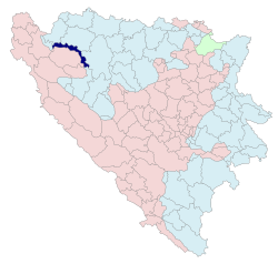
Country Bosnia and Herzegovina
Government
 - Mayor Drena Kuridža (SNSD) [1]
Population (1991)
 - Total 1,443
 - Municipality ?
Time zone CET (UTC+1)
 - Summer (DST) CEST (UTC+2)
Area code(s) 52

Oštra Luka (Bosnian Cyrillic: Оштра Лука) is a village and a municipality in Bosnia and Herzegovina. The municipality is situated in the northwestern part of the Republika Srpska entity and the central part of the Bosanska Krajina region. The municipality was also known as Srpski Sanski Most (Српски Сански Мост) and was formed after the Dayton Agreement from part of the pre-war municipality of Sanski Most (the other part of the pre-war municipality is now in the entity of Federation of Bosnia and Herzegovina).

Contents

Geography

Municipality is located between municipalities of Bosanski Novi / Novi Grad and Prijedor in the north, Banja Luka in the east, Ribnik in the south, Sanski Most in the south and west, and Bosanska Krupa in the west.

Demographics

1991

In 1991, the population of Oštra Luka village numbered 1,443 people.

External links

Coordinates: 44°51′28″N 16°39′38″E / 44.8578°N 16.6606°E / 44.8578; 16.6606


Wikimedia Foundation. 2010.

Игры ⚽ Поможем сделать НИР

Look at other dictionaries:

  • Ostra Luka — Oštra Luka Oštra Luka Оштра Лука [[Image:|100px|center|Blason]] [[Image:|100px|center|Drapeau]] Blason Drapeau …   Wikipédia en Français

  • Ostrá Lúka — Wappen Karte …   Deutsch Wikipedia

  • Oštra Luka — Municipalidades de la República Srpska de Bosnia y Herzegovina …   Wikipedia Español

  • Ostrá Lúka — (Village) Administration Pays  Slovaquie …   Wikipédia en Français

  • Ostra Luka — may refer to: Oštra Luka, a municipality in Bosnia Ostrá Lúka, a village and municipality in southern Slovakia This disambiguation page lists articles about distinct geographical locations with the same name. If an …   Wikipedia

  • Oštra Luka —  Pour l’article homonyme, voir Oštra Luka (Orašje).  44° 51′ 28″ N 16° 39′ 38″ E …   Wikipédia en Français

  • Ostrá Lúka — Zvolen District in the Banska region Ostrá Lúka is a village and municipality of the Zvolen District in the Banská Bystrica Region of Slovakia …   Wikipedia

  • Oštra Luka (Orašje) —  Pour l’article homonyme, voir Oštra Luka.  45° 00′ 00″ N 18° 35′ 18″ E …   Wikipédia en Français

  • Ostra Luka — Original name in latin Otra Luka Name in other language State code BA Continent/City Europe/Sarajevo longitude 44.99724 latitude 18.58464 altitude 85 Population 3923 Date 2012 04 06 …   Cities with a population over 1000 database

  • Duge Njive (Oštra Luka) — Pour les articles homonymes, voir Duge Njive. 44° 52′ 25″ N 16° 23′ 27″ E …   Wikipédia en Français

Share the article and excerpts

Direct link
Do a right-click on the link above
and select “Copy Link”