- North Rona
-
North Rona Location 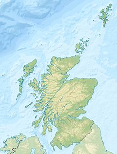
 North Rona
North Rona shown within Scotland OS grid reference HW811323 Names Gaelic name  Rònaigh (help·info)
Area and summit Area 109 hectares Area rank 144 Highest elevation Tobha Rònaigh 108 m[1] Population Population 0 Groupings Island group North Atlantic Local Authority Comhairle nan Eilean Siar 

References [2][3] If shown, area and population ranks are for all Scottish islands and all inhabited Scottish islands respectively. Population data is from 2001 census.  Cave on North Rona
Rona (Scottish Gaelic: Rònaigh, pronounced [rˠɔːnaji]) is a remote Scottish island in the North Atlantic. Rona is often referred to as North Rona in order to distinguish it from South Rona (another small island, in the Inner Hebrides). It has an area of 109 hectares (270 acres) and a maximum height of 108 metres (354 ft)[1][3][4]
The island lies 71 kilometres (44 mi) north north east of Butt of Lewis and 18 kilometres (11 mi) east of Sula Sgeir. More isolated than St Kilda, it is the remotest island in the British Isles to have ever been inhabited on a long-term basis. It is also the closest neighbour to the Faroe Islands. Due to the island's remote location and small area, it is omitted from many maps of the United Kingdom.
Contents
History

Ronay Island.[5] Rona is said to have been the residence of Saint Ronan in the eighth century. The island continued to be inhabited until the entire population of thirty died shortly after 1685 after an infestation by rats, probably the Black Rat Rattus rattus, which reached the island after a shipwreck. The rats raided the food stocks of barley meal and it is possible the inhabitants starved to death, although plague may have been a contributory factor. This occurred in a year in which it is reported that no further ships reached the isolated island to supply or trade. The rats themselves eventually starved to death, the huge swells the island experiences preventing their hunting along the rocky shores.[6]
It was resettled, but again depopulated by around 1695 in some sort of boating tragedy, after which it remained home to a succession of shepherds and their families, until 1844 when it was deserted. Sir James Matheson, who bought Lewis in 1844, offered the island to the Government for use as a penal settlement. The offer was refused.
Although farmers from Lewis have continued to graze sheep on Rona ever since, the island has remained uninhabited, apart from one brief and tragic episode in 1884–85. In June 1884, two men from Lewis, Malcolm MacDonald and Murdo Mackay, having reportedly had a dispute with the minister of their local church, went to stay on Rona to look after the sheep. In August, boatmen who had called at the island reported that the men were well and in good spirits, and had refused offers to take them back to Lewis. In April 1885, the next people to visit Rona made a grim discovery: the bodies of the two men from Lewis, who, a post-mortem subsequently showed, had fallen ill and died during the winter.
During World War I, the commander of German U-boat U-90, Walter Remy, stopped his submarine at North Rona during each of his wartime patrols, weather permitting, and sent crewmen onto the island to shoot sheep to obtain mutton for on-board consumption.[7]
The island was occupied temporarily in 1938–39 by author and conservationist Frank Fraser Darling with his wife Bobbie and their son Alasdair, while they studied the Grey Seals and the breeding seabirds.
The island still boasts the Celtic ruins of St Ronan's Chapel. It is owned by Scottish Natural Heritage, and managed as a nature reserve, for its important grey seal and seabird colonies. These include the European Storm-petrel and the larger Leach's Storm-petrel, for which North Rona is an important breeding locality. Rona and Sula Sgeir form the most remote and least-visited National Nature Reserve in Britain.[8]
In Island at the edge of the world, the poet Kathleen Jamie describes a recent visit to the island.[9]
The island hosts an automatic light beacon, remotely monitored by the Northern Lighthouse Board.[10]
See also
- List of outlying islands of Scotland
- BBC Radio 3 Feature on North Rona
Notes
- ^ a b Ordnance Survey
- ^ 2001 UK Census per List of islands of Scotland
- ^ a b Haswell-Smith (2004) pp. 326-329.
- ^ Boyd (1986) p. 119 states that the height is 116 metres and the area 120 acres.
- ^ Harvie-Brown, J. A. & Buckley, T. E. (1889), A Vertebrate Fauna of the Outer Hebrides. Pub. David Douiglas, Edinburgh. Facing P. XXXVI.
- ^ Fraser Darling & Boyd (1969) pp. 73–74.
- ^ Gleaves( 1921) p. 219.
- ^ Scottish Natural Heritage - In the Lap of Wild Ocean. Retrieved 28 June 2007
- ^ Island at the edge of the world
- ^ "Overview of North Rona". Gazetteer for Scotland. http://www.scottish-places.info/features/featurefirst1967.html. Retrieved 2007-12-15.
References
- Boyd, John Morton (1986) Fraser Darling's Islands. Edinburgh University Press. ISBN 0-85224-514-9
- Fraser Darling, F. & Boyd, J.M. (1969) Natural History in the Highlands and Islands. London. Bloomsbury.
- Gleaves, Albert (1921). A History of the Transport Service: Adventures and Experiences of United States Transports and Cruisers in the World War. New York: George H. Doran Company. OCLC 976757. http://books.google.com/books?id=_7lDrNswDnoC.
- Haswell-Smith, Hamish (2004). The Scottish Islands. Edinburgh: Canongate. ISBN 1841954543.
- Nisbet, HC and Gailey, R A (1962) 'A survey of the antiquities of North Rona', Archaeological Journal Vol.117, p88-115.
Further reading
- Island Going by Robert Atkinson (Collins, 1949)
- A Naturalist on Rona: essays of a biologist in isolation by Frank Fraser Darling (Clarendon Press: Oxford, 1939)
- Island Years by Frank Fraser Darling (G. Bell & Sons, 1940)
- Rona, the Distant Island by Michael Robson (Acair, 1991)
External links
- North Rona - Special Area of Conservation
- Rona and Sula Sgeir - Scotland's National Nature Reserves
- Charles Tait Photographs of North Rona
- Scheduled Ancient Monuments
- Information on the church and oratory at RCAHMS
Coordinates: 59°07′19″N 5°49′30″W / 59.12196°N 5.82488°W
Inhabited islands of the Hebrides Inner Hebrides 
Outer Hebrides Baleshare · Barra · Benbecula · Berneray · Eriskay · Flodaigh · Fraoch-eilean · Great Bernera · Grimsay (North) · Grimsay (South) · Lewis and Harris · North Uist · Scalpay · South Uist · VatersayCategories:- Islands of the Outer Hebrides
- Uninhabited islands of Scotland
- National Nature Reserves in Scotland
- Former populated places in Scotland
- Seabird colonies
- Archaeological sites in the Western Isles
- Important Bird Areas of the United Kingdom
- Protected areas of the Outer Hebrides


Wikimedia Foundation. 2010.