- Interstate 80 in Nevada
-
This article is about the section of Interstate 80 in Nevada. For the entire length of the highway, see Interstate 80.
Interstate 80

Map of Nevada with I-80 in redRoute information Maintained by NDOT Length: 410.674 mi[2] (660.916 km) Existed: June 29, 1956[1] – present Major junctions West end:  I-80 at California state line
 US 395 (I-580) in Reno


 US 95 Alt. to US 50 Alt. in Fernley
US 95 near Lovelock
US 95 in Winnemucca
 US 93 in Wells
US 93 Alt. in West WendoverEast end:  I-80 at Utah state line
Highway system Main route of the Interstate Highway System
Main • Auxiliary • Business← US 50SR 88  →
→In the U.S. state of Nevada, Interstate 80 (I-80) traverses the northern portion of the state. The freeway serves the Reno-Sparks metropolitan area, and also goes through the towns of Fernley, Lovelock, Winnemucca, Battle Mountain, Elko, Wells and West Wendover on its way through the state.
I-80 follows the historical routes of the California Trail, First Transcontinental Railroad, and Feather River Route throughout portions of Nevada. Throughout the entire state I-80 follows the historical routes of the Victory Highway, State Route 1, and U.S. Route 40 (US 40). The freeway corridor follows the paths of the Truckee and Humboldt Rivers. These rivers have been used as a transportation corridor since the California Gold Rush of the 1840s.
Contents
Route description
Truckee River
I-80 enters Nevada in the canyon of the Truckee River, paralleling the California Trail and the First Transcontinental Railroad. Upon exiting the canyon the freeway serves the Truckee Meadows, a name for the urban area consisting of Verdi, Reno and Sparks. The freeway passes north of Downtown Reno in a depressed alignment before intersecting U.S. Route 395 (unsigned Interstate 580). The intersection with US 395 is the busiest portion, averaging 122,000 vehicles per day in 2006.[3] The freeway passes through downtown Sparks via a viaduct over the casino floor of John Ascuaga's Nugget Casino Resort. After leaving the Reno/Sparks metropolitan area the freeway resumes following the Truckee River in a canyon to Fernley. Traffic volumes drop to 26,600 vehicles per day by Fernley and continue dropping 8,400 by the time the freeway reaches the center of the state.[3] The freeway exits the Truckee River corridor near Wadsworth.[4]
Lahontan Valley/Forty Mile Desert

Past Wadsworth, the freeway cuts across the Lahontan Valley. The Lahontan Valley is a barren desert, sometimes called the Forty Mile Desert, from the era of the California Trail. The name comes from the California Gold Rush where the emigrants who came into the Lahontan Valley via the Humboldt River. The travelers would have then to endure 40 miles (64 km) without usable water while crossing the valley, regardless of which of the two routes across the valley the travelers followed.[5] I-80 closely approximates the path of the emigrants between the Humboldt and Truckee Rivers.
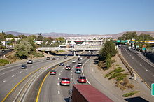 I-80 in Downtown Reno
A marker stands at a rest area on the eastern edge of the valley, near the junction of I-80 and US 95, that honors travelers who suffered crossing the valley, thousands of whom abandoned possessions, animals, and even loved ones in the desert. Per the marker, this portion was the most dreaded portion of the California Trail.[4][5][6]
Humboldt River
 I-80 near Wells
 West of Elko
For the next 246 miles (396 km), I-80 follows the Humboldt River.[7][8] Along the way the freeway passes through the towns of Lovelock, Winnemucca, Battle Mountain, Carlin, Elko and Wells. At Winnemucca, I-80 is joined by the Feather River Route; I-80 runs parallel to this railroad until the Utah state line.[4] The freeway is within visual distance of the river for most of this run. However, there are portions where the freeway bypasses bends by cutting across or tunneling under mountains along the canyon walls. Between Winnemucca and Battle Mountain, the freeway bypasses bends via side canyons and Golconda Summit, 5,159 feet (1,572 m).[4] The highway also bypasses Palisade Canyon (between Beowawe and Carlin) via Emigrant Pass 6,114 feet (1,864 m).[4] Just east of Carlin I-80 passes through the Carlin Tunnel to bypass curves in the river.[9]
Eastern Nevada
 Approaching West Wendover.
After Wells, I-80 departs the Humboldt River, First Transcontinental Railroad, and the California Trail.[4] From this point east the freeway follows the routes of Hastings Cutoff, Feather River Route, former U.S. Route 40 and State Route 1. The freeway cuts across two mountain ranges before arriving at the Great Salt Lake Desert. The first is the Pequop Mountains via Pequop Summit, elevation 6,967 feet (2,124 m). The second is the Toano Range via Silver Zone Pass at 5,955 feet (1,815 m). Pequop Summit is the highest point on Interstate 80 in Nevada. After crossing these mountains the freeway arrives at West Wendover where the freeway enters both Utah and the Great Salt Lake Desert at the Bonneville Salt Flats.[4]
Overlaps
Portions of I-80 run concurrently with three U.S. Highways in Nevada:[8]
- US 95 Alt, which runs concurrently with I-80 between Fernley and Trinity Junction near Lovelock.
- US 95, which runs concurrently with I-80 between Trinity Junction and Winnemucca.
- US 93 Alt, which runs concurrently with I-80 between the towns of Wells and West Wendover.
History
 State Route 1 - The first designation for what is now I-80 across Nevada, from approx. 1929-1939[10]
 Until 1975, the route of I-80 was designated U.S. Route 40.
California Trail
The route of Interstate 80 was first used by California-bound travelers and was called the California Trail. From the Utah State line until modern Wells, I-80 follows a lesser used branch of the trail called Hastings Cutoff. The cutoff rejoins the main route of the trail near Wells. The main route of the California Trail is approximated by modern State Route 233 in eastern Nevada.
From Wells west to Lovelock, I-80 faithfully follows the California Trail. West of Lovelock, in the middle of the Humboldt Sink, the California Trail again splits into two branches. These branches, the Carson River route and the Truckee River route, are named for the waterways that guide each branch up the Sierra Nevada mountains. I-80 follows the Truckee route, the Carson route is approximated by U.S. Route 95, U.S. Route 50, U.S. Route 395 and State Route 88/California State Route 88.[4]
Transcontinental railroads
The route of modern I-80 was also previously used for the construction of two transcontinental railroads. The First Transcontinental Railroad, completed in 1869, closely followed the main line of the California Trail, and I-80 west of Wells. The Feather River Route was constructed in 1909, and generally follows the Hastings Cutoff through eastern Nevada. It also runs parallel to I-80 in Nevada east of Winnemucca.[4]
Highways
The first paved road across this portion of Nevada was the Victory Highway, designated in Nevada as State Route 1. With the formation of the U.S. Highway system, this route was numbered U.S. Route 40. From the formation of the Interstate Highway System the highway was gradually upgraded to Interstate Highway standards and signed Interstate 80. In 1974, officials in Utah initiated meetings with officials in Nevada and California to truncate the route of U.S. Route 91. By that time US 91 was mostly redundant with Interstate 15. Nevada officials agreed and further suggested that both US 91 and US 40 be truncated. Nevada officials recommended the changes occur in 1975, when the last Nevada piece of I-15 was expected to be complete.[11] The 1976 edition of the Official Highway map for Nevada was the first not showing the US 40 designation.[10] Even though the US Highway designation was removed, the freeway was not yet complete.[10] The last piece of I-80 in Nevada to be finished was the Lovelock bypass that started in 1981.[12] The 1982 Official Nevada Highway Map was the first to note I-80 as a contiguous freeway across the state. All of the business loops for I-80 in Nevada use the historical route of US 40.[10]
Interstate 80 is also known in Nevada as the Dwight D. Eisenhower Highway and Purple Heart Trail.[10]
Exit list
County Location Mile[8] Exit Destinations Notes Washoe 1 Verdi (I-80 Bus. east) Westbound exit and entrance 2.8 2 Verdi (I-80 Bus. east / To SR 425) No westbound entrance 3.2 3 Verdi Westbound exit and eastbound entrance 4.8 4 Boomtown Garson Road 5.7 5 East Verdi (I-80 Bus. west, SR 425) Westbound exit and eastbound entrance 7.0 7 Mogul 7.7 8 West 4th Street (SR 647) Eastbound exit and westbound entrance Reno 9.2 9 Robb Drive 10.7 10 McCarran Boulevard West (SR 659) 12.5 12 Keystone Avenue (to I-80 Bus.) 13.3 13 Virginia Street – Downtown Reno serves University of Nevada, Reno 14.1 14 Wells Avenue serves Reno Livestock-Events Center 14.9 15 US 395 (I-580 south) – Carson City, SusanvilleSparks 15.4 16 Victorian Avenue, East 4th Street (SR 647) 16.1 17 Rock Boulevard (SR 668), Nugget Avenue serves Victorian Square; eastbound exit only for Nugget Avenue 16.8 18  SR 445 (Pyramid Way)
serves Victorian Square 17.6 19 McCarran Boulevard East (SR 659, to I-80 Bus. west) 18.9 20 Sparks Boulevard serves Sparks Marina 19.7 21 Vista Boulevard, Greg Street 22.6 22 Lockwood 24.0 23 Mustang 28.2 28 Patrick 32.1 32 USA Parkway replaced former Tracy, Clark Station exit as of 1/21/2008; serves Tahoe-Reno Industrial Center 36.9 36 Derby Dam 39.0 38 Orchard 40.2 40 Painted Rock Wadsworth 44.0 43 Wadsworth, Pyramid Lake (I-80 Bus. east, SR 427) Lyon Fernley 46.4 46 West Fernley (I-80 Bus., SR 427) 48.9 48
US 95 Alt. south (I-80 Bus. west) to US 50 Alt. – FernleyWest end of US 95 Alt. overlap Churchill 65.2 65 Nightingale Hot Springs 78.9 78 Jessup 83.3 83 US 95 south – Fallon, Las VegasEast end of US 95 Alt. overlap; west end of US 95 overlap Pershing 93.5 93 Toulon Lovelock 105.5 105 Lovelock (I-80 Bus. east / SR 396) Eastbound exit and westbound entrance 106.4 106 Lovelock (SR 398) 107.2 107 Lovelock (I-80 Bus. west / SR 856) Westbound exit and eastbound entrance 112.9 112 Coal Canyon (SR 396) 120.2 119 Oreana, Rochester (SR 858) 129.6 129 Rye Patch Dam (SR 401) 138.7 138 Humboldt 146.0 145 Imlay 150.3 149  SR 400 – Mill City, Unionville
152.1 151 Mill City, Dun Glen 158.7 158 Cosgrave Humboldt 168.4 168 Rose Creek 173.4 173 West Winnemucca Boulevard (I-80 Bus. east) Winnemucca 176.7 176 US 95 north – Winnemucca, BoiseEast end of US 95 overlap 179.0 178  SR 289 – Winnemucca
180.8 180  SR 794 (East Winnemucca Boulevard, I-80 Bus. west)
187.7 187 Button Point 194.5 194 Golconda, Midas (SR 789) 200.5 200 Golconda Summit 204.1 203 Iron Point 205.6 205 Pumpernickel Valley 212.5 212 Stone House 217.2 216 Valmy 222.7 222 Mote Lander Battle Mountain 230.2 229  SR 304 (I-80 Bus. east) – Battle Mountain
231.7 231  SR 305 – Battle Mountain
233.6 233 SR 304 (I-80 Bus. west) – Battle Mountain244.7 244 Argenta Eureka 254.5 254 Dunphy 261.4 261  SR 306 – Beowawe, Crescent Valley
269.2 268 Emigrant 271.6 271 Palisade Elko Carlin 280.0 279  SR 278 (I-80 Bus. east / SR 221) – Carlin, Eureka
Eastbound exit and westbound entrance 281.4 280  SR 766 – Carlin, Eureka
282.7 282  SR 221 (I-80 Bus. west) – Carlin
293.3 292 Hunter Elko 299.2 298 Elko (I-80 Bus. east / SR 535) 301.9 301  SR 225 – Elko Downtown
304.4 303 Elko (I-80 Bus. west) 311.5 310 Osino 315.5 314 Ryndon, Devils Gate 317.7 317 Elburz 322.2 321  SR 229 – Halleck, Ruby Valley
329.0 328 River Ranch 334.5 333 Deeth, Starr Valley (SR 230) 344.4 343 Welcome, Starr Valley (SR 230) 348.2 348 Beverly Hills Wells 351.6 351 Wells (I-80 Bus. east / SR 223 / SR 231) 352.5 352A US 93 – East WellsWest end of US 93 Alt. overlap; signed as exit 352 eastbound 352B Wells (I-80 Bus. west) Westbound exit only 360.7 360 Moor 365.9 365 Independence Valley 373.8 373 Summit 376.5 376 Pequop 379.4 378  SR 233 – Oasis, Montello
388.1 387 Shafter 399.2 398 Pilot Peak West Wendover 407.2 407 Ola 410.4 410
US 93 Alt. south (I-80 Bus. east) – West Wendover, ElyEast end of US 93 Alt. overlap 1.000 mi = 1.609 km; 1.000 km = 0.621 mi References
- ^ Weingroff, Richard F. "Federal-Aid Highway Act of 1956: Creating the Interstate System". Federal Highway Administration. http://www.fhwa.dot.gov/infrastructure/rw96e.htm. Retrieved 2008-05-11.
- ^ "Nevada State Maintained Highways: Descriptions, Index and Maps". Nevada Department of Transportation. January 2008. http://www.nevadadot.com/reports_pubs/state_maintained/pdf/sm_book.pdf. Retrieved 2009-11-05.
- ^ a b "2006 Annual Traffic Report". Nevada Department of Transportation. http://www.nevadadot.com/reports_pubs/traffic_report/2006/. Retrieved 2008-05-11.
- ^ a b c d e f g h i Benchmark Maps (2003). Nevada Road and Recreation Atlas (Map). 1:250000. p. 47. ISBN 0-929591-81-X. http://www.benchmark.com.
- ^ a b "Forty-Mile Desert: Nevada Historical Marker 26". State Historic Preservation. Nevada Department of Cultural Affairs. 2008. http://nevadaculture.org/shpo/index.php?option=com_content&task=view&id=155&Itemid=9. Retrieved 2009-11-06.
- ^ Brock, Dick. "Photos and transcription of markers along the Forty Mile Desert, placed by the Oregon/California Trails Association". Trails West Inc.. http://www.emigranttrailswest.org/crscenes2.htm.
- ^ Using distance between Lovelock and Wells
- ^ a b c Nevada Department of Transportation (2009). 2009-2010 Official Highway Map (Map). http://www.nevadadot.com/traveler/maps/StateMaps/pdfs/officialmap2009.pdf. Retrieved 2009-11-05.
- ^ Turner, Dan. "Carlin Canyon, Elko County, Nevada". Elko Rose Garden Association. http://www.elkorose.com/carlincanyon.html.
- ^ a b c d e "Historical Maps". Nevada Department of Transportation. http://www.nevadadot.com/traveler/maps/historical/.
- ^ "Highway Resolution route 91". Utah Department of Transportation. http://www.dot.utah.gov/main/uconowner.gf?n=200609181116091. Retrieved 2008-03-08.
- ^ "NDOT News Spring 2006". Nevada Department of Transportation. 2006. http://www.nevadadot.com/reports_pubs/ndot_news/pdfs/spring2006.pdf. Retrieved 2008-02-26.
External links
 Interstate 80
Previous state:
CaliforniaNevada Next state:
UtahAuxiliary routes of Interstate 80 California: 180 (former) • 280 • 380 • 480 (former) • 580 • 680 • 780 • 880 • 880 (former) • 980 — Nevada: 580 (unsigned) — Wyoming: 180 — Nebraska: 180 • 280 (former) • 480 • 580 (former) • 680 — Iowa: 280 • 380 • 480 • 680 — Illinois: 180 • 280 — Ohio: 280 • 480 • 680 — Pennsylvania: 180 • 180 (former) • 280 (former) • 380 • 480 (former) • 680 (former) — New Jersey: 280 • 680 (former)
Interstate Highways in Nevada Current Unsigned Categories:- Interstate Highways in Nevada
- Interstate 80
- U.S. Route 40
- California Trail
- Humboldt River


Wikimedia Foundation. 2010.