- Dunipace
-
Coordinates: 56°01′42″N 3°54′51″W / 56.028236°N 3.914073°W
Dunipace 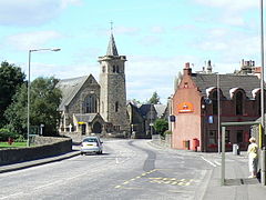
Dunipace Church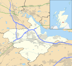
 Dunipace
Dunipace shown within the Falkirk council areaArea 0.24 sq mi (0.62 km2) Population 2,441 [1] (2001 census) - Density 10,171 /sq mi (3,927 /km2) OS grid reference NS807833 - Edinburgh 28.6 mi (46.0 km) ESE - London 349 mi (562 km) SSE Council area Falkirk Lieutenancy area Stirling and Falkirk Country Scotland Sovereign state United Kingdom Post town DENNY Postcode district FK6 Dialling code 01324 Police Central Scotland Fire Central Scotland Ambulance Scottish EU Parliament Scotland UK Parliament Falkirk Scottish Parliament Central Scotland Falkirk West Website falkirk.gov.uk List of places: UK • Scotland • Dunipace is a village in the west of the Falkirk council area of Scotland. The village is 6.3 miles (10.1 km) south of Stirling and 5.3 miles (8.5 km) north-west of Falkirk. The village is situated on the north bank of the River Carron and adjoins the town of Denny to the south of the river.
The main road through Dunipace is the A872 road between Denny and Stirling. Based on the 2001 census, Falkirk council reported the population of Dunipace as being 2,441 residents.[1]
Contents
History
In 1876 Dunipace was joined with Denny to form the Denny and Dunipace Burgh. This was abolished in 1975 when both areas became part of Falkirk District.
A legend exists that the famous Scottish patriot William Wallace, lived in Dunipace with his uncle, who was a clergyman at the parish church.[citation needed]
Amenities
Dunipace is mainly residential, and has a church , a primary school , a few shops (including two hairdressers) and two pubs: The Anchor Inn and The Red House. The Red Hoose was used as a filming location for hit Scottish comedy Still Game in the New Year's episode of 2007.[citation needed]
Sports
Dunipace also has a Junior League football team, Dunipace F.C.. The club was formed in 1888 and is based at Westfield Park. They currently compete in the West Region of the Scottish Junior Football Association.
See also
- List of places in Falkirk council area
References
- ^ a b No 3 - 2001 Census Population of settlements and wards www.falkirk.gov.uk. Retrieved 2011-05-08
External links
Towns 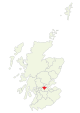
Villages Other villages Allandale · Avonbridge · Binniehill · Blackness · California · Dennyloanhead · Dunmore · Fankerton · Glensburgh · Greenhill · Haggs · Head of Muir · High Bonnybridge · Letham · Limerigg · Longcroft · Muirhouses · Reddingmuirhead · Rumford · Skinflats · South Alloa · Standburn · Stoneywood · Tamfourhill · Torwood · Wallacestone · Westquarter · WhitecrossCategories:- Villages in Falkirk council area


Wikimedia Foundation. 2010.