- Texas State Highway 85
Infobox TX State Highway
type=State
route=85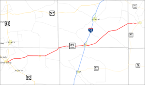
length_mi=76.926
length_ref=TxDOT|SH|85|accessdate=2008-03-03]
length_round=3
formed=by 1926cite map|url=http://www.broermapsonline.org/members/NorthAmerica/UnitedStates/SouthCentral/Texas/|title=Texas Road Map|publisher=Rand McNally |year=1926|accessdate=2008-03-03]
dir1=West
dir2=East
from=jct|state=TX|US|83 at Carrizo Springs
junction=jct|state=TX|I|35
to=jct|state=TX|SH|97 west of Charlotte
previous_type=State
previous_route=84
next_type=State
next_route=86State Highway 85 or SH 85 is a
state highway in theU.S. state ofTexas that runs almost 77 miles from Carrizo Springs to Charlotte.History
SH 85 was originally designated by 1926 along a route from Del Rio to Dilley via Eagle Pass and Carrizo Springs. In 1950, the section from Del Rio to Carrizo Springs was transferred to newly extended U.S. Highway 277. SH 85 was extended along its current route to Charlotte in the late 1960s.
Route description
SH 85 begins at an intersection with US 83 in Carrizo Springs. The highway heads east from this junction and has an intersection with FM 1917 before leaving Carrizo Springs. East of the city, the highway heads to the northeast as it intersects FM 1556 and FM 1407 and passes near the
Dimmit County Airport . The highway turns back towards the east before a crossing of theNueces River . SH 85 turns back towards the northeast after the river crossing before turning back towards the east near Brundage, where it has an intersection with FM 65. The highway continues to the east as it heads towards Big Wells, where it intersects FM 1867. East of Big Wells, the highway once again turns towards the northeast near an intersection with FM 468. SH 85 curves towards the north-northeast before entering Frio County. Once in Frio County, the highway curves back to the east. It curves back towards the northeast as it approaches the city of Dilley. In Dilley, SH 85 has an interchange with I-35. Heading east from Dilley, the highway turns back towards the northeast before crossing theFrio River . SH 85 continues northeast to an intersection with FM 1582 before crossing into Atascosa County. The highway curves back to the east as it enters Atascosa County. The highway ends at SH 97 west of the city limits of Charlotte.cite map|url=http://maps.google.com/maps?f=d&hl=en&geocode=8150697727330198346,28.522900,-99.856520%3B15550007705264072747,28.854185,-98.715029&saddr=E+Nopal+St%2FTX-85+%4028.522900,+-99.856520&daddr=TX-85+%4028.854185,+-98.715029&doflg=ptm&sll=28.68866,-99.285775&sspn=0.837265,1.349945&ie=UTF8&z=10|title=Overview map of SH 85|publisher=Google Maps |accessdate=2008-03-03]Junction list
References

Wikimedia Foundation. 2010.