- Nizhny Novgorod Oblast
-
Nizhny Novgorod Oblast Нижегородская область (Russian) — Oblast — 
Flag
Coat of arms
Coordinates: 56°29′N 44°32′E / 56.483°N 44.533°ECoordinates: 56°29′N 44°32′E / 56.483°N 44.533°E Political status Country Russia Federal district Volga[1] Economic region Volga-Vyatka[2] Established December 5, 1936 Administrative center Nizhny Novgorod Government (as of March 2011) - Governor Valery Shantsev[3] - Legislature Legislative Assembly Statistics Area (as of the 2002 Census)[4] - Total 76,900 km2 (29,691.3 sq mi) Area rank 40th Population (2010 Census)[5] - Total 3,310,562 - Rank 10th - Density 43.05 /km2 (111.5 /sq mi) - Urban 78.9% - Rural 21.1% Population (2002 Census)[6] - Total 3,524,028 - Rank 10th - Density 45.83 /km2 (118.7 /sq mi) - Urban 78.8% - Rural 21.8% Time zone(s) MSD (UTC+04:00)[7] ISO 3166-2 RU-NIZ License plates 52, 152 Official languages Russian[8] http://www.government-nnov.ru/ Nizhny Novgorod Oblast (Russian: Нижегоро́дская о́бласть, Nizhegorodskaya oblast) is a federal subject of Russia (an oblast). Its administrative center is the city of Nizhny Novgorod. Population: 3,310,562 (2010 Census preliminary results).[5]
The oblast is crossed by the Volga River. Apart from Nizhny Novgorod's metropolitan area, the biggest city is Arzamas. Near the town of Sarov there is the largest and the most famous convent[citation needed] in Russia, established by Saint Seraphim of Sarov - Diveevo convent. Makaryev Monastery opposite the town of Lyskovo used to be location of the largest fair in Eastern Europe. Other historic towns include Gorodets and Balakhna, located on the Volga to the north from Nizhny Novgorod.
Contents
Geography
The oblast covers an area of 76,900 square kilometers (29,700 sq mi), which is approximately equal to the entire area of the Benelux countries. Agricultural land occupies 41% of this area; forests, 48%, lakes and rivers, 2%; and other lands, 9%. Nizhny Novgorod Oblast borders Kostroma Oblast (N), Kirov Oblast (NE), the Mari El Republic (E), the Chuvash Republic (E), the Republic of Mordovia (S), Ryazan Oblast (SW), Vladimir Oblast (W), and Ivanovo Oblast (NW).
Natural resources
Nizhny Novgorod Oblast is not rich in natural resources, which are, mostly, limited to commercial deposits of sand (including titanium-zirconium sands), clay, gypsum, peat, mineral salt, and timber.
Sights
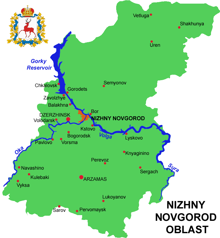
 Map of Nizhny Novgorod Oblast
 Savior's Church, Balakhna
 Shukhov towers built in Nizhny Novgorod suburbs near Dzerzhinsk in 1927–1929
The unique architectural construction—the 128-meter (420 ft) steel lattice hyperboloid tower built by the Great Russian engineer and scientist Vladimir Grigorievich Shukhov in 1929—is located near the town of Dzerzhinsk on the left bank of the Oka River.
Administrative divisions
Main article: Administrative divisions of Nizhny Novgorod OblastDemographics
According to the 2002 Census, ethnic Russians at 3,346,398 made up 95% of the oblast's population. Other ethnic groups included Tatars (50,609, or 1.4%), Mordva (25,022, or 0.7%), Ukrainians (24,241, or 0.7%), and various smaller groups, each accounting for less than 0.5% of the oblast's total population. 758 persons (0.02%) did not indicate their nationalities during the Census.
The population density is 48.5 people per square kilometer[citation needed].
Nizhny Novgorod Oblast is one of the most multi-religious regions of Russia.[citation needed]
- Population: 3,310,562 (2010 Census preliminary results)[5]
- Population: 3,524,028 (2002)[6]
- Urban: 2,754,997
- Rural: 769,031
- Male: 1,600,609 (45.4%)
- Female: 1,923,419 (54.6%)
- Females per 1000 males: 1202
- Median age: 39.8
- Urban: 39.1
- Rural: 43.3
- Male: 36.1
- Female: 42.7
- Number of households: 1,362,027 (with 3,465,935 people)
- Urban: 1,051,602 (with 2,720,077 people)
- Rural: 310,425 (with 745,858 people)
- Births (2008): 35,581 (10.6 per 1000)
- Deaths (2008): 61,140 (18.3 per 1000)
Births increased by 7.7% and deaths decreased by 1% in 2008 compared to 2007.[9]
According to the Federal Migration Service, 20,450 foreign citizens were registered in the oblast in 2006. The actual number of foreigners residing in the oblast as of June 1, 2006 was estimated to be over 22,000.[10]
Economy
The oblast ranks seventh in Russia in industrial output, while the processing industry predominates in the local economy. More than 650 industrial companies employ nearly 700 000 people, or 62% of the workforce involved in material production. Industry generates 83% of the regional GDP and makes 89% of all material expenditures. The leading sectors are engineering and metalworking, followed by the chemical and petrochemical industries and the forestry, woodworking, and paper industries. The first three sectors account for about 75% of all industrial production.
The oblast has traditionally been attractive to investors. In 2002, Moody's rating agency confirmed a Caa1rating based on the region's long-term foreign currency liabilities.[11]
The region maintains trade relations with many countries and has an export surplus. The largest volume of exports goes to Ukraine, Belarus, Switzerland, Kazakhstan, Belgium, and France. Imports come mainly from Ukraine, Germany, Belarus, Kazakhstan, Austria, the Netherlands, China, and the United States.
The stock market infrastructure is quite well developed in Nizhny Novgorod, and the exchange business is expanding. Companies and organizations registered in the region include 1153 joint-stock companies, 63 investment institutions, 34 commercial banks, 35 insurance companies, 1 voucher investment fund, 1 investment fund, 17 nongovernmental pension funds, 2 associations of professional stock market dealers, and 3 exchanges (stock, currency, and agricultural). The oblast is noted for having relatively highly developed market relations. Today, the region needs serious partners interested in equitable, long-term, mutually beneficial partnerships.
 A shopping centre in Fedyakovo
There are 650+ industrial companies in the region [1], most of them engaged in the following sectors:
- Machine-building and engineering
- Chemical & petrochemical
- Fuel & energy
- Ferrous and non-ferrous metallurgy
- Construction materials
- Glass
- Wood and paper
- Cloth-making
- Food & food processing
- Medical & pharmaceuticals
- Printing & publishing.
These key industries are supplemented by other sectors of the economy such as agriculture, trade, services, communications and transport.
References
 Media related to Nizhny Novgorod Oblast at Wikimedia Commons
- ^ Президент Российской Федерации. Указ №849 от 13 мая 2000 г. «О полномочном представителе Президента Российской Федерации в федеральном округе». Вступил в силу 13 мая 2000 г. Опубликован: "Собрание законодательства РФ", №20, ст. 2112, 15 мая 2000 г. (President of the Russian Federation. Decree #849 of May 13, 2000 On the Plenipotentiary Representative of the President of the Russian Federation in a Federal District. Effective as of May 13, 2000).
- ^ Госстандарт Российской Федерации. №ОК 024-95 27 декабря 1995 г. «Общероссийский классификатор экономических регионов. 2. Экономические районы», в ред. Изменения №5/2001 ОКЭР. (Gosstandart of the Russian Federation. #OK 024-95 December 27, 1995 Russian Classification of Economic Regions. 2. Economic Regions, as amended by the Amendment #5/2001 OKER. ).
- ^ Official website of Nizhny Novgorod Oblast. Valery Pavlinovich Shantsev, Governor of Nizhny Novgorod Oblast
- ^ Федеральная служба государственной статистики (Federal State Statistics Service) (2004-05-21). "Территория, число районов, населённых пунктов и сельских администраций по субъектам Российской Федерации (Territory, Number of Districts, Inhabited Localities, and Rural Administration by Federal Subjects of the Russian Federation)" (in Russian). Всероссийская перепись населения 2002 года (All-Russia Population Census of 2002). Federal State Statistics Service. http://perepis2002.ru/ct/html/TOM_01_03.htm. Retrieved 2011-11-01.
- ^ a b c Федеральная служба государственной статистики (Federal State Statistics Service) (2011). "Предварительные итоги Всероссийской переписи населения 2010 года (Preliminary results of the 2010 All-Russian Population Census)" (in Russian). Всероссийская перепись населения 2010 года (All-Russia Population Census of 2010). Federal State Statistics Service. http://www.perepis-2010.ru/results_of_the_census/results-inform.php. Retrieved 2011-04-25.
- ^ a b Федеральная служба государственной статистики (Federal State Statistics Service) (2004-05-21). "Численность населения России, субъектов Российской Федерации в составе федеральных округов, районов, городских поселений, сельских населённых пунктов – районных центров и сельских населённых пунктов с населением 3 тысячи и более человек (Population of Russia, its federal districts, federal subjects, districts, urban localities, rural localities—administrative centers, and rural localities with population of over 3,000)" (in Russian). Всероссийская перепись населения 2002 года (All-Russia Population Census of 2002). Federal State Statistics Service. http://www.perepis2002.ru/ct/doc/1_TOM_01_04.xls. Retrieved 2010-03-23.
- ^ Правительство Российской Федерации. Постановление №725 от 31 августа 2011 г. «О составе территорий, образующих каждую часовую зону, и порядке исчисления времени в часовых зонах, а также о признании утратившими силу отдельных Постановлений Правительства Российской Федерации». Вступил в силу по истечении 7 дней после дня официального опубликования. Опубликован: "Российская Газета", №197, 6 сентября 2011 г. (Government of the Russian Federation. Resolution #725 of August 31, 2011 On the Composition of the Territories Included into Each Time Zone and on the Procedures of Timekeeping in the Time Zones, as Well as on Abrogation of Several Resolutions of the Government of the Russian Federation. Effective as of after 7 days following the day of the official publication).
- ^ Official the whole territory of Russia according to Article 68.1 of the Constitution of Russia.
- ^ http://nizhstat.gks.ru/digital/region1/2007/oper_demogr_12_08.htm
- ^ Дарья ВЛАДИМИРОВА, "Стройки под особым контролем", Rakurs, 30 June 2006
- ^ http://russiatrek.org/r_nnovgorod.shtml
External links
- Nizhny Novgorod City Guide Travel and business guide to Nizhny Novgorod (English)
Subdivisions of Russia Republics Krais Oblasts - Amur
- Arkhangelsk
- Astrakhan
- Belgorod
- Bryansk
- Chelyabinsk
- Irkutsk
- Ivanovo
- Kaliningrad
- Kaluga
- Kemerovo
- Kirov
- Kostroma
- Kurgan
- Kursk
- Leningrad
- Lipetsk
- Magadan
- Moscow
- Murmansk
- Nizhny Novgorod
- Novgorod
- Novosibirsk
- Omsk
- Orenburg
- Oryol
- Penza
- Pskov
- Rostov
- Ryazan
- Sakhalin
- Samara
- Saratov
- Smolensk
- Sverdlovsk
- Tambov
- Tomsk
- Tula
- Tver
- Tyumen
- Ulyanovsk
- Vladimir
- Volgograd
- Vologda
- Voronezh
- Yaroslavl
Federal cities Autonomous oblasts Autonomous okrugs 1administratively subordinated to Tyumen Oblast 2 administratively subordinated to Arkhangelsk Oblast
Categories:- Nizhny Novgorod Oblast
- States and territories established in 1936


Wikimedia Foundation. 2010.