- Mow Cop
-
Coordinates: 53°06′47″N 2°13′03″W / 53.112973°N 2.217582°W
Mow Cop 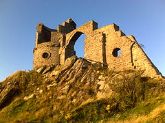
Mow Cop Castle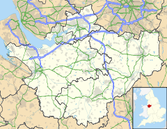
 Mow Cop
Mow Cop shown within CheshireOS grid reference SJ855573 Parish Odd Rode Kidsgrove District Cheshire East Newcastle-under-Lyme Shire county Cheshire Staffordshire Region North West West Midlands Country England Sovereign state United Kingdom Post town STOKE-ON-TRENT Postcode district ST7 Dialling code 01782 Police Cheshire Staffordshire Fire Cheshire Staffordshire Ambulance North West West Midlands EU Parliament North West England West Midlands UK Parliament Congleton Staffordshire Moorlands List of places: UK • England • Cheshire Mow Cop (
 /ˈmaʊˈkɒp/) is an isolated village which straddles the Cheshire–Staffordshire border, and is thus divided between the North West and West Midlands regions of England. It is 24 miles south of Manchester and 6 miles north of Stoke-on-Trent.
The name is first recorded as "Mowel" around 1270 AD, and is believed to be derived from either the Anglo-Saxon Mūga-hyll, meaning "heap-hill", with copp = "head" added later, or the Common Celtic ancestor of Welsh moel (= hill), with Anglo-Saxon copp added later.
At the village's summit, men once quarried stone to make into querns, used since the Iron Age for milling corn; this trade ended during the Victorian period. The village also has a long history of coal mining. Mow Cop Castle is a folly of a ruined castle at the summit of the hill, built in 1754. The village was served by a railway station which was opened by the North Staffordshire Railway on October 9, 1848. Mow Cop is known for its 'Killer Mile', a one mile road race from the level crossing on the western side of the hill, up to the Castle. The race was originated in the early 1980s by John Britton, and sponsored by ICL (Kidsgrove). It continues today, organised by the Mow Cop Residents' Association. Mow Cop Runners, a local running club founded in 2009, meet at The Ash Inn and organise The Mow Cop Hill Race, a 6.5 mile fell race.
Mow Cop is also noteworthy as the birthplace of the Primitive Methodist movement. Starting in 1800, Hugh Bourne from Stoke-on-Trent and William Clowes from Burslem began holding open-air prayer meetings. On 31 May 1807, a large 14-hour camp meeting was held and as a result the Primitive Methodist Church was formed in 1810. These camp meetings became a regular feature at Mow Cop, with camps later held to celebrate the 100th, 150th and 200th anniversaries of the first camp.
The village features prominently in the 1973 novel Red Shift by Alan Garner.
Notable residents
- Charles Machin : former Port Vale F.C. director
- Alan Jones : former Port Vale Football Club director
External links
Ceremonial county of Cheshire Unitary authorities Major settlements Rivers Topics - History
- Museums
Ceremonial county of Staffordshire Unitary authorities Boroughs or districts Major settlements Rivers Canals Topics MuseumsCategories:- Villages in Cheshire
- Villages in Staffordshire
- Newcastle-under-Lyme
- Cheshire geography stubs
- Staffordshire geography stubs


Wikimedia Foundation. 2010.