- Oryol
-
For other uses, see Oryol (disambiguation).
Oryol (English)
Орёл (Russian)- City[citation needed] - 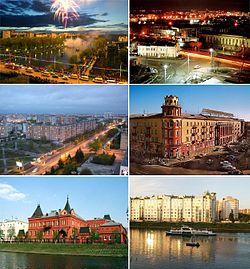
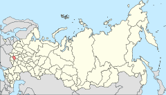
Location of Oryol Oblast in Russia
 Oryol
OryolCoordinates: 52°58′N 36°04′E / 52.967°N 36.067°ECoordinates: 52°58′N 36°04′E / 52.967°N 36.067°E 

Coat of arms Flag City Day August 5[citation needed] Administrative status Country Russia Federal subject Oryol Oblast Administrative center of Oryol Oblast[citation needed] Municipal status Urban okrug Oryol Urban Okrug[citation needed] Mayor[citation needed] Vasily Yeryomin[citation needed] Representative body City Duma[citation needed] Statistics Area 111 km2 (43 sq mi)[citation needed] Population (2010 Census,
preliminary)317,854 inhabitants[1] - Rank in 2010 57th Population (2002 Census) 333,310 inhabitants[2] - Rank in 2002 54th Density 2,864 /km2 (7,420 /sq mi)[3] Time zone MSD (UTC+04:00)[4] Founded 1566[citation needed] Postal code(s) 302000–302999[citation needed] Dialing code(s) +7 4862[citation needed] Official website Oryol or Orel (Russian: Орёл, IPA: [ɐˈrʲol]) is a city and the administrative center of Oryol Oblast, Russia, located on the Oka River, approximately 360 kilometers (220 mi) south-southwest of Moscow. Population: 317,854 (2010 Census preliminary results);[1] 333,310 (2002 Census);[2] 336,862 (1989 Census).[5] It is served by Oryol Yuzhny Airport.
Contents
History
While there are no historical records, archaeological evidence proves that a fortress settlement existed between the Oka and Orlik Rivers as early as the 12th century, when the land was a part of the Grand Principality of Chernigov. The name of the fortress is unknown; it may not have been called Oryol at the time. In the 13th century the fortress became a part of the Zvenigorod district of the Karachev Principality. In the early 15th century, the territory was conquered by the Grand Duchy of Lithuania. The city was soon abandoned by its population, after being sacked either by Lithuanians or the Golden Horde. The territory became a part of Muscovy in the 16th century.
Ivan the Terrible decreed that a new fortress be built on the spot in 1566, for the purpose of defending the southern borders of Muscovy. The fortress was built very speedily, work starting in the summer of 1566 and ending in the spring of 1567. The location chosen was less than ideal strategically, as the fortress was located on a seasonally flooded low ground easily targeted from the neighboring high ground. Both the speed and location are of course due to the new fortress built upon the ruins of the old one.
False Dmitry I and his army passed through town in 1605; Ivan Bolotnikov in 1606; False Dmitry II camped in Oryol for the winter of 1607–1608. Polish intervention sacked the town in 1611 and 1615; the population abandoned the town after the second sacking and moved to Mtsensk. Oryol district nonetheless continued to exist on paper.
Oryol was rebuilt in 1636. The question of moving the fortress to the more advantageous high ground was in the air up until the 1670s, but the move was never made. The fortress was deemed unnecessary and taken apart in the early 18th century.
In the mid-18th century Oryol became one of the major centers of grain production, with the Oka River being the major trade route until 1860s when it was replaced by a railroad.
Oryol was granted town status in 1702. In 1708, Oryol was included as a part of Kiev Governorate; in 1719, Oryol Province was created within Kiev Governorate. The Province was transferred to the newly created Belgorod Governorate in 1727. On March 11 (February 28 old style), 1778 Oryol Vice-Royalty was created from parts of Voronezh and Belgorod Governorates. In 1779, the city was almost entirely rebuilt based on a new plan; and the Oryol River was renamed Orlik (lit: "little eagle").
After the October Revolution of 1917, the city was in communist hands, except for a brief period between October 13 and October 20 of 1919 when it was controlled by Anton Ivanovich Denikin’s White Army.
Oryol was once again moved between different oblasts in the 1920s and 1930s, finally becoming the administrative center of its own Oryol Oblast on September 27, 1937. Christian Rakovsky, Maria Spiridonova, Olga Kameneva and 160 other prominent political prisoners were shot on September 11, 1941 on Joseph Stalin's orders in the Medvedev forest outside Oryol.
During World War II, Oryol was occupied by the Wehrmacht on October 3, 1941, and liberated on 5 August 1943, after the Battle of Kursk. The city was almost completely destroyed.
-

View of the city
-
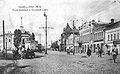
Oryol street around 1900
-

Modern Oryol
Mayors
- 1991–1997: Alexander Kislyakov
- 1997–2002: Yefim Velkovsky
- 2002–2006: Vasily Uvarov
- 2006–2009: Alexander Kasyanov
International relations
Main article: List of twin towns and sister cities in RussiaTwin towns/sister cities
Oryol is twinned with:
 Brest, Belarus
 Kerch, Crimea, Ukraine
 Leeuwarden, Friesland, Netherlands [6]
 Nokia, Finland
 Razgrad, Bulgaria (since 1968)
Notable natives and residents
 The sculpture on the Railway Station Square of the city
- Leonid Andreyev, playwright
- Mikhail Bakhtin, literary critic, born in 1895 in Orel.[7]
- Felix Edmundovich Dzerzhinsky, first head of CheKa
- Afanasy Fet, poet
- Nikolai Getman, painter and Gulag survivor, died in Orel
- Timofey Granovsky, historian
- Vasily Kalinnikov, Composer 1866–1901
- Yakov Kasman, pianist, 1997 Van Cliburn Silver Medalist
- Anna Petrovna Kern, socialite
- Stanislav Lebamba, Afro Russian Footballer
- Nikolai Leskov, novelist
- Denis Menchov, professional cyclist, winner of the Giro d'Italia 2009 and the 2005 and 2007 Vuelta a España
- Artem Mikoyan, founder of the famous MiG aircraft manufacturer
- Fritz Noether, mathematician, was shot in Orel in 1941 during the Stalinist period
- Nikolai Nikolaevich Polikarpov, aviation designer
- Yevgeni Preobrazhensky, Bolshevik leader
- Vladimir Karlovich Roth, noted neuropathologist
- Valerian Safonovich, Oryol governor in 1854—1861
- Alexey Stakhanov, worker
- Pyotr Arkadyevich Stolypin, statesman
- Yakov Sverdlov, Bolshevik revolutionary, died in Orel
- Ivan Turgenev, novelist and playwright
- Aleksey Petrovich Yermolov, military general
- Gennady Zyuganov, head of Communist Party of the Russian Federation
- Denis Boytsov, Professionnal Boxer
References
- ^ a b Федеральная служба государственной статистики (Federal State Statistics Service) (2011). "Предварительные итоги Всероссийской переписи населения 2010 года (Preliminary results of the 2010 All-Russian Population Census)" (in Russian). Всероссийская перепись населения 2010 года (All-Russia Population Census of 2010). Federal State Statistics Service. http://www.perepis-2010.ru/results_of_the_census/results-inform.php. Retrieved 2011-04-25.
- ^ a b Федеральная служба государственной статистики (Federal State Statistics Service) (2004-05-21). "Численность населения России, субъектов Российской Федерации в составе федеральных округов, районов, городских поселений, сельских населённых пунктов – районных центров и сельских населённых пунктов с населением 3 тысячи и более человек (Population of Russia, its federal districts, federal subjects, districts, urban localities, rural localities—administrative centers, and rural localities with population of over 3,000)" (in Russian). Всероссийская перепись населения 2002 года (All-Russia Population Census of 2002). Federal State Statistics Service. http://www.perepis2002.ru/ct/doc/1_TOM_01_04.xls. Retrieved 2010-03-23.
- ^ The value of density was calculated automatically by dividing the 2010 Census population by the area specified in the infobox. Please note that this value may not be accurate as the area specified in the infobox does not necessarily correspond to the area of the entity proper or is reported for the same year as the population.
- ^ Правительство Российской Федерации. Постановление №725 от 31 августа 2011 г. «О составе территорий, образующих каждую часовую зону, и порядке исчисления времени в часовых зонах, а также о признании утратившими силу отдельных Постановлений Правительства Российской Федерации». Вступил в силу по истечении 7 дней после дня официального опубликования. Опубликован: "Российская Газета", №197, 6 сентября 2011 г. (Government of the Russian Federation. Resolution #725 of August 31, 2011 On the Composition of the Territories Included into Each Time Zone and on the Procedures of Timekeeping in the Time Zones, as Well as on Abrogation of Several Resolutions of the Government of the Russian Federation. Effective as of after 7 days following the day of the official publication).
- ^ "Всесоюзная перепись населения 1989 г. Численность наличного населения союзных и автономных республик, автономных областей и округов, краёв, областей, районов, городских поселений и сёл-райцентров. (All Union Population Census of 1989. Present population of union and autonomous republics, autonomous oblasts and okrugs, krais, oblasts, districts, urban settlements, and villages serving as district administrative centers.)" (in Russian). Всесоюзная перепись населения 1989 года (All-Union Population Census of 1989). Demoscope Weekly (website of the Institute of Demographics of the State University—Higher School of Economics. 1989. http://demoscope.ru/weekly/ssp/rus89_reg.php. Retrieved 2010-03-23.
- ^ Sister cities
- ^ David Lodge, After Bakhtin: Essays on Fiction and Criticism, London & New York: Routledge, 1990, p. 1
External links
 Media related to Oryol at Wikimedia Commons
- Oryol telephone directory
- Oryol Web Portal
- Oryol Wiki
Cities and towns in Oryol Oblast Administrative center: Oryol

Cities of Military Glory of Russia Arkhangelsk · Belgorod · Bryansk · Dmitrov · Kalach-na-Donu · Kozelsk · Kronstadt · Kursk · Luga · Malgobek · Nalchik · Naro-Fominsk · Oryol · Polyarny · Pskov · Rostov-on-Don · Rzhev · Tikhvin · Tuapse · Tver · Velikiye Luki · Veliky Novgorod · Vladikavkaz · Vladivostok · Volokolamsk · Voronezh · Vyazma · Vyborg · Yelets · Yelnya
Categories:- Oryol
- Cities of Military Glory
-


Wikimedia Foundation. 2010.