- Derbent
-
This article is about the city in the Republic of Dagestan, Russia. For the district in Konya Province, Turkey, see Derbent, Konya.
Derbent (English)
Дербент (Russian)- City[citation needed] - 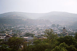
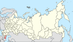
Location of the Republic of Dagestan in Russia
 Derbent
Coordinates: 42°04′N 48°17′E / 42.067°N 48.283°ECoordinates: 42°04′N 48°17′E / 42.067°N 48.283°E Administrative status Country Russia Federal subject Republic of Dagestan Capital of Republic of Dagestan[citation needed] Statistics Population (2010 Census,
preliminary)119,961 inhabitants[1] - Rank in 2010 136th Population (2002 Census) 101,031 inhabitants[2] - Rank in 2002 163rd Time zone MSD (UTC+04:00)[3] Citadel, Ancient City and Fortress Buildings of Derbent * UNESCO World Heritage Site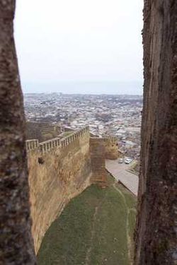
Country  Russia
Type Cultural Criteria iii, iv Reference 1070 Region ** Europe Inscription history Inscription 2003 (27th Session) * Name as inscribed on World Heritage List
** Region as classified by UNESCODerbent (Russian: Дербе́нт; Lezgian: Кьвевар; Azerbaijani: Dərbənd; Avar: Дербенд; Lak: Чурул, Churul; Persian: دربند; Judæo-Tat: דארבּאנד/Дэрбэнд/Dərbənd[4]) is a city in the Republic of Dagestan, Russia, close to the Azerbaijani border. It is the southernmost city in Russia, and it is the second most important city of Dagestan. Population: 119,961 (2010 Census preliminary results);[1] 101,031 (2002 Census);[2] 78,371 (1989 Census).[5] The main ethnic groups are: Lezgins (32,6%), Azeris(31,7%), and Tabasarans(15%)(2002 census) [6].
Often identified with the legendary Gates of Alexander, Derbent claims to be the oldest city in Russia. Since antiquity the value of the area as the gate to the Caucasus has been understood and Derbent has archaeological structures over 5,000 years old. As a result of this geographic particularity the city developed between two walls, stretching from the mountains to the sea. These fortifications were continuously employed for a millennium and a half, longer than any other extant fortress in the world. Over the years different nations gave the city different names, but all connected to the word 'gate'.
Contents
Geography
The modern city is built near the western shores of the Caspian Sea, south of the Rubas River, on the slopes of the Tabasaran Mountains (part of the Bigger Caucasus range). Derbent is well served by public transport, with its own harbor, a railway going south to Baku, and the Baku to Rostov-on-Don road.
To the north of the town is the monument of the Kirk-lar, or forty heroes, who fell defending Dagestan against the Arabs in 728. To the south lies the seaward extremity of the Caucasian wall (fifty metres long), otherwise known as Alexander's Wall, blocking the narrow pass of the Iron Gate or Caspian Gates (Portae Athanae or Portae Caspiae). This, when entire, had a height of 29 ft (9 m) and a thickness of about 10 ft (3 m), and with its iron gates and numerous watch-towers formed a valuable defence of the Persian frontier.
History
 View of the city from Naryn-Kala, 1910s
Derbent has an important strategic location in the Caucasus: the city is situated on a narrow, three-kilometer strip of land between the Caspian Sea and the Caucasus mountains. Historically, this position allowed the rulers of Derbent to control land traffic between the Eurasian Steppe and the Middle East. The only other practicable crossing of the Caucasus ridge was over the Darial Gorge.
The first intensive settlement in the Derbent area dates from the 8th century BCE; the site was intermittently controlled by the Persian monarchs, starting from the 6th century BCE. Until the 4th century CE it was part of Caucasian Albania, and is traditionally identified with Albana, the capital. The modern name is a Persian word (دربند Darband) meaning "closed gates", which came into use in the end of the 5th or the beginning of the 6th century AD, when the city was refounded by Kavadh I of the Sassanid dynasty of Persia.
The twenty-meter-high walls with thirty north-looking towers are believed to belong to the time of Kavadh's son, Khosrau I of Persia. The chronicler Movses Kagankatvatsi wrote about "the wondrous walls, for whose construction the Persian kings exhausted our country, recruiting architects and collecting building materials with a view of constructing a great edifice stretching between the Caucasus Mountains and the Great Eastern Sea." Derbent became a strong military outpost and harbour of the Sassanid empire. During the 5th and 6th centuries Derbent becomes also an important center for spreading the Christian faith in the Caucasus.
Movses Kagankatvatsi left a graphic description of the sack of Derbent by the hordes of Tong Yabghu of the Western Turkic Khaganate in 627. His successor[citation needed], Böri Shad, proved unable to consolidate Tong Yabghu's conquests, and the city was retaken by the Persians. In 654, Derbent was captured by the Arabs, who transformed it in an important administrative center and introduced Islam to the area. In the Middle Age Moslem geographical and historical literature, Derbent is called al-Bab.[7] Because of its strategic position on the northern branch of the Silk Route, the fortress was contested by the Khazars in the course of the Khazar-Arab Wars. The Sassanids had also brought Armenians from Syunik' to help protect the pass from invaders; as Arab rule weakened in the region at the end of the ninth century, the Armenians living there were able to establish a kingdom of their own, which lasted until the early years of the thirteenth century.[8][9]
 Sassanian fortress in Derbent
Excavations on the eastern side of the Caspian Sea, opposite to Derbent, revealed the Great Wall of Gorgan, the eastern counterpart to the wall and fortifications of Derbent. Similar Sasanian defensive fortifications there—massive forts, garrison towns, long walls— also run from the sea to the mountains.
The Caliph Harun al-Rashid spent time living in Derbent, and brought it into great repute as a seat of the arts and commerce. According to Arab historians, Derbent, with population exceeding 50,000, was the largest city of the 9th century Caucasus. In the 10th century, with the collapse of the Arab Caliphate, Derbent became the capital of an emirate. This emirate often fought losing wars with the neighboring Christian state of Sarir, allowing Sarir to occasionally manipulate Derbent politics. Despite that, the emirate outlived its rival and continued to flourish at the time of the Mongol invasion in 1239.
In the 14th century Derbent was occupied by Tamerlane's armies. In 1437, it fell under the control of the Shirvanshahs of Azerbaijan. During the 16th century Derbent was the arena for wars between Turkey and Persia ruled by the Iranian Safavid dynasty. Ottoman Empire gained control of the city following the Battle of the Torches in 1583 and Ottoman ownership was secured with the Treaty of Istanbul of 1590.
By the 1735 Ganja treaty Derbent fell within the Persian state. In 1722, during the Russo-Persian War, Peter the Great of Russia wrested the town from the Persians, but in 1736 the supremacy of Nadir Shah was again recognized. In 1747, Derbent became the capital of the khanate of the same name.
During the Persian Expedition of 1796, Derbent was stormed by Russian forces under Valerian Zubov. As a consequence of the Treaty of Gulistan of 1813—between Russian and Persia—Derbent became part of the Russian Empire.
 The Caspian Gates
A large portion of the walls and several watchtowers have been preserved in reasonable shape till our days. The walls, reaching to the sea, date from the 6th century, Sassanid dynasty period. The city has a well preserved citadel (Narin-kala), comprising an area of 45,000 m², enclosed by strong walls. Historical attractions include the baths, the cisterns, the old cemeteries, the caravanserai, the 18th century Khan's mausoleum, as well as several mosques. The oldest mosque is the Juma Mosque, built over a 6th century Christian basilica; it has a 15th century madrassa. Other shrines include the 17th century Kyrhlyar mosque, the Bala mosque and the 18th century Chertebe mosque.
International relations
Main article: List of twin towns and sister cities in RussiaTwin towns/sister cities
Derbent is twinned with:
Economy and culture
The city is home to machine building, food, textile, fishing and fishery supplies, construction materials and wood industries. It is the production center of Russian brandy. The education infrastructure is fairly extensive; there is a university as well as several technical schools. On the cultural front, there is a Lezgin drama theater (named after S. Stalsky). About two kilometers from the city is the vacation colony of Chayka (Seagull).
Derbent being in practice a huge museum and with magnificent mountains and shore nearby, a great potential for development of the tourism industry exists, further increased by UNESCO's classification of the Citadel, Ancient City and Fortress as a World Heritage Site in 2003; however, instability in the region has not allowed further development.
-

Coat of arms of Derbent (1843)
-

A gate in the old city of Derbent
-

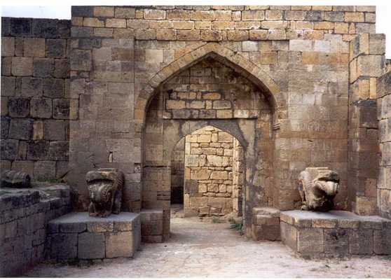
A gate of the citadel
-

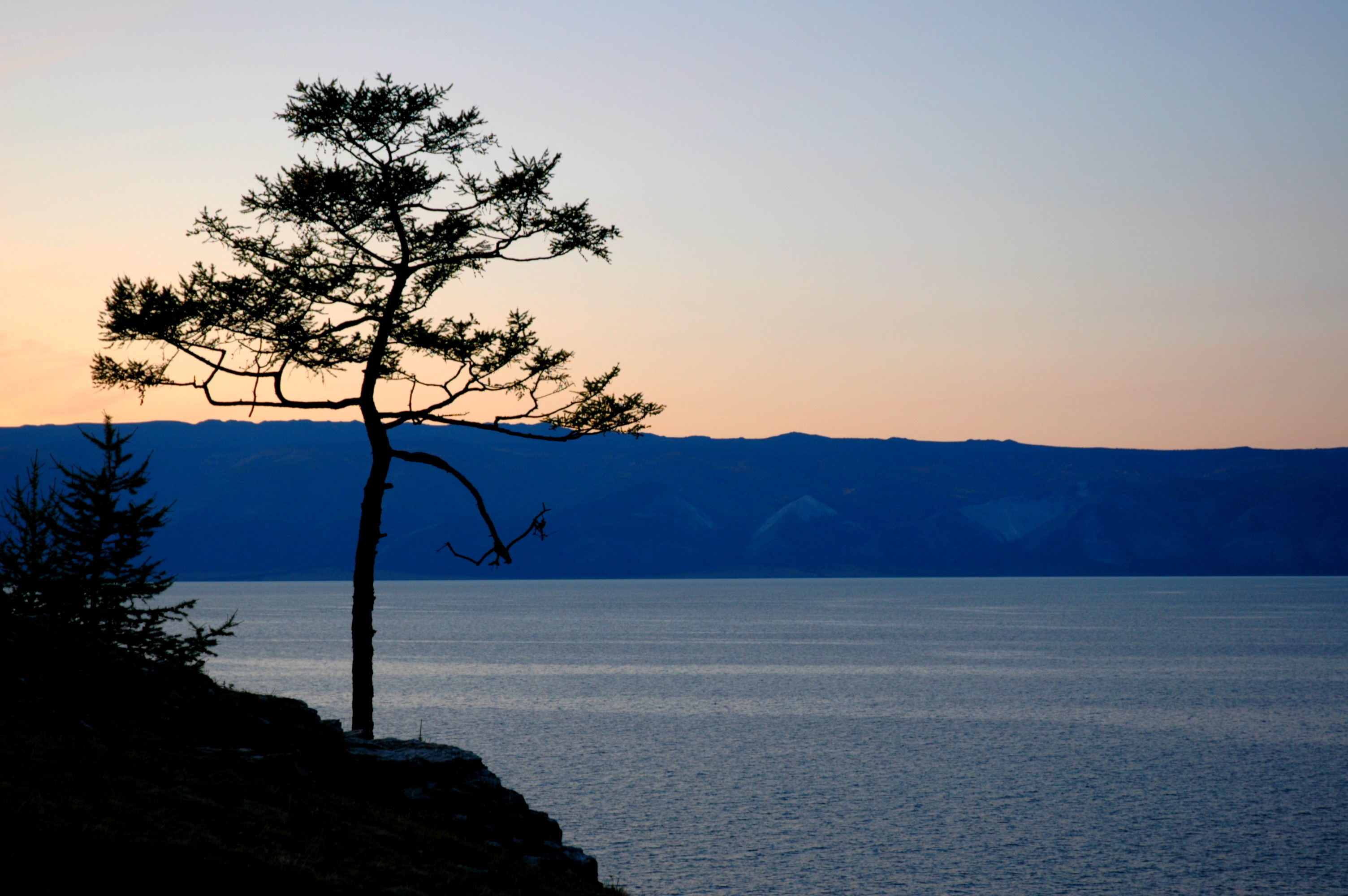
View on the Caspian Sea
Notes
- ^ a b Федеральная служба государственной статистики (Federal State Statistics Service) (2011). "Предварительные итоги Всероссийской переписи населения 2010 года (Preliminary results of the 2010 All-Russian Population Census)" (in Russian). Всероссийская перепись населения 2010 года (All-Russia Population Census of 2010). Federal State Statistics Service. http://www.perepis-2010.ru/results_of_the_census/results-inform.php. Retrieved 2011-04-25.
- ^ a b Федеральная служба государственной статистики (Federal State Statistics Service) (2004-05-21). "Численность населения России, субъектов Российской Федерации в составе федеральных округов, районов, городских поселений, сельских населённых пунктов – районных центров и сельских населённых пунктов с населением 3 тысячи и более человек (Population of Russia, its federal districts, federal subjects, districts, urban localities, rural localities—administrative centers, and rural localities with population of over 3,000)" (in Russian). Всероссийская перепись населения 2002 года (All-Russia Population Census of 2002). Federal State Statistics Service. http://www.perepis2002.ru/ct/doc/1_TOM_01_04.xls. Retrieved 2010-03-23.
- ^ Правительство Российской Федерации. Постановление №725 от 31 августа 2011 г. «О составе территорий, образующих каждую часовую зону, и порядке исчисления времени в часовых зонах, а также о признании утратившими силу отдельных Постановлений Правительства Российской Федерации». Вступил в силу по истечении 7 дней после дня официального опубликования. Опубликован: "Российская Газета", №197, 6 сентября 2011 г. (Government of the Russian Federation. Resolution #725 of August 31, 2011 On the Composition of the Territories Included into Each Time Zone and on the Procedures of Timekeeping in the Time Zones, as Well as on Abrogation of Several Resolutions of the Government of the Russian Federation. Effective as of after 7 days following the day of the official publication).
- ^ Its etymology derives from the Persian Darband ("closed gate"); it was known to the Arabs as Bāb al Abwab ("Gate of Gates") and to the Turks as Demirkapı ("Iron Gate").
- ^ "Всесоюзная перепись населения 1989 г. Численность наличного населения союзных и автономных республик, автономных областей и округов, краёв, областей, районов, городских поселений и сёл-райцентров. (All Union Population Census of 1989. Present population of union and autonomous republics, autonomous oblasts and okrugs, krais, oblasts, districts, urban settlements, and villages serving as district administrative centers.)" (in Russian). Всесоюзная перепись населения 1989 года (All-Union Population Census of 1989). Demoscope Weekly (website of the Institute of Demographics of the State University—Higher School of Economics. 1989. http://demoscope.ru/weekly/ssp/rus89_reg.php. Retrieved 2010-03-23.
- ^ [1]
- ^ Gmyrya, L. 1995. Hun country at the Caspian Gate: Caspian Dagestan during the epoch of the Great Movement of Peoples. Makhachkala: Dagestan Publishing, p. 37on, ISВN 5-297-01099-3
- ^ See (Armenian) Sedrak Barkhudaryan, “Դերբենդի հայ-աղվանական թագավորությունը” (“The Armenian-Caucasian Albanian Kingdom of Derbend”). Patma-Banasirakan Handes . № 3, 1969, pp. 125-147.
- ^ (Armenian) Matthew of Edessa. Ժամանակնագրություն (Chronicle). Translated by Hrach Bartikyan. Yerevan: Hayastan Publishing, 1973, pp. 151-152, 332, note 132a.
References
 This article incorporates text from a publication now in the public domain: Chisholm, Hugh, ed (1911). Encyclopædia Britannica (11th ed.). Cambridge University Press.
- Some text used with permission from www.travel-images.com. The original text can be found here.
External links
Administrative divisions of the Republic of Dagestan Capital: Makhachkala 
Cities and towns Buynaksk · Dagestanskiye Ogni · Derbent · Izberbash · Kaspiysk · Khasavyurt · Kizilyurt · Kizlyar · Yuzhno-Sukhokumsk
Administrative districts Agulsky · Akhtynsky · Akhvakhsky · Akushinsky · Babayurtovsky · Botlikhsky · Buynaksky · Charodinsky · Dakhadayevsky · Derbentsky · Dokuzparinsky · Gergebilsky · Gumbetovsky · Gunibsky · Karabudakhkentsky · Kayakentsky · Kaytagsky · Kazbekovsky · Khasavyurtovsky · Khivsky · Khunzakhsky · Kizilyurtovsky · Kizlyarsky · Kulinsky · Kumtorkalinsky · Kurakhsky · Laksky · Levashinsky · Magaramkentsky · Nogaysky · Novolaksky · Rutulsky · Sergokalinsky · Shamilsky · Suleyman-Stalsky · Tabasaransky · Tarumovsky · Tlyaratinsky · Tsumadinsky · Tsuntinsky · Untsukulsky World Heritage Sites in Russia by federal district

Central Church of the Ascension in Kolomenskoye · Moscow Kremlin and Red Square
Novodevichy Convent · Trinity Sergius Lavra
White Monuments of Vladimir and Suzdal · Historic Centre of Yaroslavl

Southern Northwestern Far Eastern Volcanoes of Kamchatka · Central Sikhote-Alin · Wrangel Island
Siberian Volga North Caucasian Citadel, Ancient City and Fortress Buildings of Derbent
1 Shared with Lithuania · 2 Shared with nine other countries · 3 Shared with Mongolia Categories:- Cities and towns in Dagestan
- Archaeological sites in Russia
- Populated coastal places in Russia
- Forts in Russia
- Sassanid castles
- Caucasus
- World Heritage Sites in Russia
- Wine regions of Russia
- Populated places on the Caspian Sea
-


Wikimedia Foundation. 2010.