- Mission Point Light
-
Mission Point Light 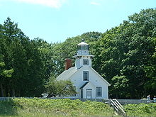
Mission Point Light Location Peninsula Township, Michigan Coordinates 44°59′28.7″N 85°28′46.1″W / 44.991306°N 85.479472°WCoordinates: 44°59′28.7″N 85°28′46.1″W / 44.991306°N 85.479472°W Year first constructed 1870 Year first lit 1870 Deactivated 1933 Construction Wood Tower shape Square tower on dwelling Markings / pattern White with black trim Height Tower – 36 feet (11 m) Focal height Focal plane – 47 feet (14 m) Original lens Fifth order Fresnel lens Range 10 miles (16 km) Characteristic Flashing W 6 seconds.[1] ARLHS number USA-504 Michigan State Historic SiteDesignated: October 15, 1992  Another view of Mission Point Lighthouse
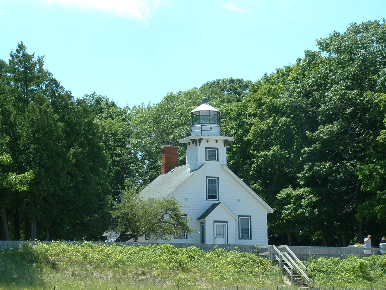
Mission Point Light is a lighthouse located in the U.S. state of Michigan at the end of Old Mission Point, a peninsula jutting into Grand Traverse Bay 17 miles (27 km) north of Traverse City. When it was built in 1870, it was an exact copy of the Mama Juda Lighthouse[2] (now destroyed), which was built on the Detroit River in 1866.[3]
The foundation is natural and emplaced. The wooden structure is painted white with black trim. The square tower is attached to a dwelling.[4]
A fixed white Fifth Order Fresnel lens was installed. The building was only one and one half stories tall. However, its placement on a sand bank fourteen feet above the lake's surface created a lens focal plane of 47 feet (14 m). It was visible from 13 miles (21 km) at sea. Maintaining the dune and protecting it and the lighthouse from the deleterious effects of wave action has been a constant struggle.[5]
For 67 years the light served to warn mariners about the shoals off the point. However, new techniques in offshore construction and the automation of lighthouse illumination made it possible to build a navigation aid on the shoal itself. In 1938, work began on a pier for the new light in 19 feet (5.8 m) of water, about 2 miles (3.2 km) northwest of Mission Point. The light ran on batteries. It was on a 36-foot (11 m) tall tower, and its focal plane of 52 feet (16 m) help make it visible for 13 miles (21 km). It had a 30 second dwell time between flashes, in order to conserve power.[5]
Famously, the lighthouse stands a few hundred yards south of the 45th parallel north, halfway between the North Pole and the Equator. The lighthouse was deactivated in 1933 and purchased by the State of Michigan.[6] There are a pair of signs that denote its location on the parallel,[7] and it is one of 29 places (six are in Michigan) in the U.S.A. where such signs are known to exist.[8]
Contents
Current status and activities
The lighthouse is now part of the Lighthouse Park in Peninsula Township at the northern end of M-37.[9]
As reported in the Traverse City Record Eagle, in a unique program, the lighthouse society sought volunteers to work and live in the Mission Point Light during 2008. There is a fee, which will benefit the light.[10]
In 2008, the building opened for the first time to the public (it will have a small museum),[11] after serving for many years as the park manager's residence.[6]
The area around the lighthouse attracts many cross country skiers. There is a boat launch there, which is favored by sea kayakers. The location is becoming increasingly popular, which has subjected it to environmental issues that are being addressed by Peninsula Township.[12]
The Old Mission Peninsula is said to be a premier place to sea kayak. One gets close to shore, lighthouse, picnic grounds and parks. The bay offers a shelter from the prevailing westerly winds and from the Lake Michigan waves. Maps, rentals and guided tours are available.[13]
Because of its form, surroundings and location, it is photogenic, having inspired photographs and illustrations, including drawings[14] and needlepoint.[15]
See also
References
- ^ (PDF) Light List, Volume VII, Great Lakes. Light List. United States Coast Guard. http://www.navcen.uscg.gov/pdf/lightLists/LightList%20V7.pdf.
- ^ Lighthouse depot, Mama Juda Light.
- ^ Biggs, Jerry, Mission to Mama, Lighthouse Digest, 10/2000.
- ^ NPS Inventory of Historic Light Stations.
- ^ a b Terry Pepper, Mission Point lighthouse at Seeing the Light.
- ^ a b Rowlett, Russ. "Lighthouses of the United States: Michigan's Western Lower Peninsula". The Lighthouse Directory. University of North Carolina at Chapel Hill. http://www.unc.edu/~rowlett/lighthouse/miwl.htm.
- ^ Photographs, Old Mission 45th Parallel signs.
- ^ List and map of 45th Parallel markers, with links to pictures (accessed 2007-12-17).
- ^ M-37 Endpoint Photos.
- ^ Lighthouse directory, Mission Point volunteer story.
- ^ Wood TV 8, Lighthouse to open to public, caretakers wanted.
- ^ Peninsula Township Parks.
- ^ Sea kayaking
- ^ Mulgrew, Marilyn, Drawing of MIssion Point Light.
- ^ Needlepoint of MIssion Point Light.
Bibliography
- Bibliography on Michigan lighthouses.
- Crompton, Samuel Willard & Michael J. Rhein, The Ultimate Book of Lighthouses (2002) ISBN 1-59223-102-0; ISBN 978-1-59223-102-7.
- Hyde, Charles K., and Ann and John Mahan. The Northern Lights: Lighthouses of the Upper Great Lakes. Detroit: Wayne State University Press, 1995. ISBN 0-8143-2554-8 ISBN 978-0-8143-2554-4.
- Jones, Ray & Bruce Roberts, American Lighthouses (Globe Pequot, September 1, 1998, 1st Ed.) ISBN 0-7627-0324-5; ISBN 978-0-7627-0324-1.
- Jones, Ray,The Lighthouse Encyclopedia, The Definitive Reference (Globe Pequot, January 1, 2004, 1st ed.) ISBN 0-7627-2735-7; ISBN 978-0-7627-2735-3.
- Noble, Dennis, Lighthouses & Keepers: U. S. Lighthouse Service and Its Legacy (Annapolis: U. S. Naval Institute Press, 1997). ISBN 1-55750-638-8; ISBN 978-1-55750-638-2.
- Oleszewski, Wes, Great Lakes Lighthouses, American and Canadian: A Comprehensive Directory/Guide to Great Lakes Lighthouses, (Gwinn, Michigan: Avery Color Studios, Inc., 1998) ISBN 0-932212-98-0.
- Penrod, John, Lighthouses of Michigan, (Berrien Center, Michigan: Penrod/Hiawatha, 1998) ISBN 978-0-942618-78-5 ISBN 978-1-893624-23-8.
- Penrose, Laurie and Bill, A Traveler’s Guide to 116 Michigan Lighthouses (Petoskey, Michigan: Friede Publications, 1999). ISBN 0-923756-03-5 ISBN 978-0-923756-03-1
- Pepper, Terry. "Seeing the Light: Lighthouses on the western Great Lakes". http://www.terrypepper.com/lights/index.htm.
- Putnam, George R., Lighthouses and Lightships of the United States, (Boston: Houghton Mifflin Co., 1933).
- United States Coast Guard, Aids to Navigation, (Washington, DC: U. S. Government Printing Office, 1945).
- Scott T. Price. "U. S. Coast Guard Aids to Navigation: A Historical Bibliography". United States Coast Guard Historian's Office. http://www.uscg.mil/History/weblighthouses/h_lhbib.asp.
- Wagner, John L.. "Beacons Shining in the Night: The Lighthouses of Michigan". Clarke Historical Library, Central Michigan University. http://clarke.cmich.edu/lighthouses/index.htm.
- Wagner, John L., Michigan Lighthouses: An Aerial Photographic Perspective, (East Lansing, Michigan: John L. Wagner, 1998) ISBN 1-880311-01-1 ISBN 978-1-880311-01-1.
- Wargin, Ed, Legends of Light: A Michigan Lighthouse Portfolio (Ann Arbor Media Group, 2006). ISBN 978-1-58726-251-7.
- Wright, Larry and Wright, Patricia, Great Lakes Lighthouses Encyclopedia Hardback (Erin: Boston Mills Press, 2006) ISBN 1-55046-399-3.
External links
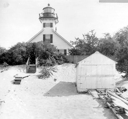
 Vintage image of the Station
- Mission Point Lighthouse - history and museum information from Peninsula Township, official site
- Aerial photos, Old Mission Point Light, marinas.com.
- Detroit News, Interactive map on Michigan lighthouses.
- Lighthouse Central, Photographs, History, Directions and Way points for Old Mission Point Light, The Ultimate Guide to West Michigan Lighthouses by Jerry Roach (Publisher: Bugs Publishing LLC – 2005). ISBN 0-9747977-0-7.
- Terry Pepper, Mission Point lighthouse at Seeing the Light.
- Article linking Mama Juda Lighthouse with Old Mission Point.
- Interactive map of Lights in Northern Lake Michigan, mapped by Google.
- Interactive map/list/information of lighthouses in northeastern Lake Michigan by LighthousesRus.
- Map of Michigan Lighthouse in PDF Format.
- Michigan Lighthouse Conservancy, Old Mission Point Lighthouse.
- National Park Service Maritime Heritage, Inventory of Historic Light Stations.
- "Historic Light Station Information and Photography: Michigan". United States Coast Guard Historian's Office. http://www.uscg.mil/history/weblighthouses/LHMI.asp. Old Mission Point light.
- Wobser, David, Boatnerd.com Old Mission Point Light.
- Youtube, Mission Point Lighthouse and 45th Parallel.
Lighthouses of Michigan See also: List of lighthouses in Michigan Northern upper peninsula Au Sable Light • Big Bay Point Light • Copper Harbor Light • Copper Harbor Front Range Light • Crisp Point Light • Eagle Harbor Light • Eagle Harbor Range Lights • Eagle River Light • Fourteen Mile Point Light • Grand Island East Channel Light • Grand Island Harbor Rear Range Light • Grand Island North Light • Granite Island Light • Gull Rock Light Station • Huron Island Light • Isle Royale Light • Manitou Island Light Station • Marquette Harbor Light • Mendota (Bete Grise) Light • Munising Front Range Light • Munising Rear Range Light • Portage River (Jacobsville) Light • Passage Island Light • Rock Harbor Light • Rock of Ages Light • Sand Hills Light • St. Martin Island Light • Stannard Rock Light • Thunder Bay Island Light • Whitefish Point LightSouthern upper peninsula DeTour Reef Light • Manistique East Breakwater Light • Martin Reef Light • Menominee Pier Light • Naubinway Island Light • Peninsula Point Light • Poverty Island Light • Sand Point Light Escanaba • Sand Point Light Baraga • Seul Choix Light • Squaw Island Light • White Shoal LightSt. Mary's River Frying Pan Island Light • Pipe Island Light • Point Iroquois Light • Round Island Light (St. Mary's River) • Six Mile Point Range Rear LightPortage River/Ship Canal Keweenaw Waterway (Portage Lake) Lower Entrance • Keweenaw Waterway Upper Entrance Light • Rouleau Point Range Front and Rear LightsStraits of Mackinac Bois Blanc Light • McGulpin Point Light • Old Mackinac Point Light • Round Island Light • Round Island Passage • St. Helena Island LightWestern lower peninsula Beaver Island Harbor Light • Beaver Island Head Light • Big Sable Point Light • Charlevoix Light • Charlevoix South Pier Light • Frankfort Light • Frankfort South Range Light • Grand Haven Light • Grand Haven South Pierhead Outer Light • Grand Haven Main Light • Gray's Reef Light • Holland Harbor Light • Ile Aux Galets • Little Sable Point Light • Little Traverse Light • Ludington Light • Manistee Main Light • Manistee Pierhead lights • Miller Memorial Light • Mission Point Light • Mission Point Light (2) • Muskegon Breakwater Light • Muskegon Pier Light • Point Betsie Light • South Fox Island • South Haven Light • South Manitou Island Light • Waugoshance Light • White River LightEastern lower peninsula Alpena Light • Bellanger Park (Ecorse) Light • Caseville Harbor (Saginaw Bay) • Belle Isle Light • Charity Island Light • Cheboygan River Range Front Light • Cheboygan Crib Light • Detroit River Light • Fort Gratiot Light • Forty Mile Point Light • Fourteen Foot Shoal Light • Gibraltar Light • Gravelly Shoal Light • Harbor Beach Light • Manning Memorial Light • Mariners Memorial (River Rouge) Light • New Presque Isle Light • Old Presque Isle Light • Poe Reef Light • Pointe aux Barques Light • Port Austin Light • Port Sanilac Light • Saginaw River Range Front Light • Saginaw River Rear Range Light • Spectacle Reef Light • St. Clair Flats Front and Rear Range Light • Sturgeon Point Light • Tawas Point Light • Tri-Centennial Light of Detroit • William Livingtone Memorial LightHistorical (lost) lights Au Sable North Pierhead • Clinton River Light • Ecorse Light • Ecorse Range Rear • Gibraltar Light • Grassy Island Lighthouse • Grassy Island North Channel Range • Grassy Island South Channel Range • Grosse Isle South Channel Range • Harwood Point East Range Front (St. Mary's River) • Mama Juda Light • Mama Juda Range Front • Middle Lake George • Monroe Pier • New Buffalo • North Manitou Island • Rouleau Point Range Front and Rear • Saginaw Bay • Sand Beach North Entrance East • Squaw Point • St. Mary's River Lower Range Front • Turtle Island Light • Vidal Shoals Channel Range Front and Rear • Windmill Point Range Front and Rear • Winter Point Range FrontRelated – Lightship Huron, List of lifesaving stations in Michigan Categories:- Lighthouses in Michigan
- Museums in Grand Traverse County, Michigan
- Lighthouse museums in Michigan
Wikimedia Foundation. 2010.