- Shire of Moorabool
-
Shire of Moorabool
Victoria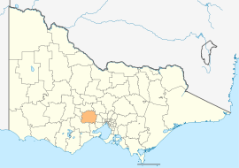
Location in VictoriaPopulation: 27,896(2009)[1] Established: 1994 Area: 2110 km² (814.7 sq mi) Mayor: Dianne McAuliffe Council Seat: Ballan State District: Ballarat East, Melton Federal Division: Ballarat 
LGAs around Shire of Moorabool: Hepburn Hepburn Macedon Ranges Ballarat Shire of Moorabool Melton Golden Plains Greater Geelong Wyndham The Shire of Moorabool is a Local Government Area in Victoria, Australia. It is located in the southwestern part of the state. It has an area of 2,110 square kilometres. In 2006 it had a population of 25,474.
The administrative centre is at Ballan, while the largest urban centre is Bacchus Marsh. Other small population areas in the east are Balliang, Mount Wallace and Myrniong, in the centre Blackwood, Greendale, Gordon, Koorweinguboora and Mount Egerton and to the west Bungaree, Elaine and Wallace.
The shire was formed in 1994 by the amalgamation of the Shire of Bacchus Marsh, Shire of Ballan and parts of Shire of Bungaree and the City of Werribee.
Contents
Wards
- Bungal
- East Moorabool
- West Moorabool
- Woodlands
East Moorabool ward is represented by four elected Councillors, the other wards by one elected Councillor.
See also
References
- ^ Australian Bureau of Statistics (30 March 2010). "Regional Population Growth, Australia, 2008–09". http://www.abs.gov.au/ausstats/abs@.nsf/Latestproducts/3218.0Main%20Features52008-09?opendocument&tabname=Summary&prodno=3218.0&issue=2008-09&num=&view=. Retrieved 3 June 2010.
- ^ Local Government Victoria. "Moorabool Shire Council". http://www.localgovernment.vic.gov.au/web20/dvclgv.nsf/AllDocs/792B3FEB5C32699ACA2571610028762D?OpenDocument. Retrieved 2008-10-30
 Shire of Moorabool Local Government Area
External links
Towns in the Shire of Moorabool Bacchus Marsh • Ballan • Balliang • Balliang East • Barkstead • Barrys Reef • Beremboke • Blackwood • Blakeville • Bolwarrah • Bullarook • Bullarto South • Bunding • Bungal • Bungaree • Buninyong • Cargerie • Clarendon • Claretown • Clarkes Hill • Coimadai • Colbrook • Dales Creek • Darley • Dunnstown • Durham Lead • Elaine • Fiskville • Glenmore • Glen Park • Gordon • Greendale • Grenville • Hopetoun Park • Ingliston • Korobeit • Korweinguboora • Lal Lal • Leigh Creek • Lerderderg • Long Forest Maddingley • Millbrook • Meredith • Merrimu • Mollongghip • Morrisons • Mount Doran • Mount Egerton • Mount Wallace • Myrniong • Navigators Parwan • Pentland Hills • Pootilla • Rowsley • Scotsburn • Spargo Creek • Springbank • Trentham • Wallace • Warrenheip • Watten Flat • Yendon
Local Government Areas of Victoria Greater Melbourne Inner MelbourneMetropolitanBanyule · Bayside · Boroondara · Darebin · Glen Eira · Hobsons Bay · Kingston · Maribyrnong · Maroondah · Monash · Moonee Valley · Moreland · WhitehorseOuter MetropolitanBrimbank · Cardinia · Casey · Frankston · Greater Dandenong · Hume · Knox · Manningham · Melton · Mornington Peninsula · Nillumbik · Whittlesea · Wyndham · Yarra RangesSouthwest Central Highlands and Goldfields Ballarat · Central Goldfields · Greater Bendigo · Hepburn · Loddon · Macedon Ranges · Mitchell · Moorabool · Mount AlexanderGoulburn Valley Northeast Gippsland Western District Wimmera The Mallee Categories:- Populated places established in 1994
- 1994 establishments in Australia
- Local Government Areas of Victoria (Australia)
- Australia government stubs


Wikimedia Foundation. 2010.