- Chedzoy
-
Coordinates: 51°08′02″N 2°57′04″W / 51.134°N 2.951°W
Chedzoy 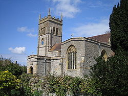
Church of St Mary, Chedzoy
 Chedzoy
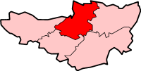
Chedzoy shown within SomersetPopulation 427 [1] OS grid reference ST335376 District Sedgemoor Shire county Somerset Region South West Country England Sovereign state United Kingdom Post town BRIDGWATER Postcode district TA7 Dialling code 01278 Police Avon and Somerset Fire Devon and Somerset Ambulance South Western EU Parliament South West England UK Parliament Bridgwater and West Somerset List of places: UK • England • Somerset Chedzoy is a civil parish village 3 miles (4.8 km) east of Bridgwater in the Sedgemoor district of Somerset, England.
Contents
History
The village is at the western end of King's Sedgemoor and lies on an 'island' of Burtle marine sands, close to King's Sedgemoor Drain. The area was settled possibly in the Mesolithic period, and timber trackways from the 3rd to 1st millennium B.C. provided routes to other settlements on the Somerset Levels. Roman artifacts have been found in the parish.[2][3]
The village is very close to the site of the Battle of Sedgemoor in 1685.
Governance
The parish council has responsibility for local issues, including setting an annual precept (local rate) to cover the council’s operating costs and producing annual accounts for public scrutiny. The parish council evaluates local planning applications and works with the local police, district council officers, and neighbourhood watch groups on matters of crime, security, and traffic. The parish council's role also includes initiating projects for the maintenance and repair of parish facilities, as well as consulting with the district council on the maintenance, repair, and improvement of highways, drainage, footpaths, public transport, and street cleaning. Conservation matters (including trees and listed buildings) and environmental issues are also the responsibility of the council.
The village falls within the Non-metropolitan district of Sedgemoor, which was formed on April 1, 1974 under the Local Government Act 1972, having previously been part of Bridgwater Rural District,[4] which is responsible for local planning and building control, local roads, council housing, environmental health, markets and fairs, refuse collection and recycling, cemeteries and crematoria, leisure services, parks, and tourism.
Somerset County Council is responsible for running the largest and most expensive local services such as education, social services, libraries, main roads, public transport, policing and fire services, trading standards, waste disposal and strategic planning.
It is also part of the Bridgwater and West Somerset county constituency represented in the House of Commons of the Parliament of the United Kingdom. It elects one Member of Parliament (MP) by the first past the post system of election, and part of the South West England constituency of the European Parliament which elects seven MEPs using the d'Hondt method of party-list proportional representation.
Religious sites
The church of St Mary dates from the 13th century and has been designated by English Heritage as a grade I listed building.[5] It still bears marks form the forces of The Duke of Monmouth during the Monmouth Rebellion who sharpened their swords before battle.[6]
References
- ^ "Parish Population Statistics for Sedgemoor". ONS Census 2001. Somerset County Council. http://www.webcitation.org/5lRyCSu4c. Retrieved 2009-12-17.
- ^ "Chedzoy". British History Online. http://www.british-history.ac.uk/report.aspx?compid=18652&strquery=Chedzoy. Retrieved 2007-12-06.
- ^ Havinden, Michael. The Somerset Landscape. The making of the English landscape. London: Hodder and Stoughton. p. 74. ISBN 0340201169.
- ^ A Vision of Britain Through Time : Bridgwater Rural District
- ^ "Church of St Mary". Images of England. http://www.imagesofengland.org.uk/details/default.aspx?id=269531. Retrieved 2007-12-06.
- ^ Leete-Hodge, Lornie (1985). Curiosities of Somerset. Bodmin: Bossiney Books. p. 81. ISBN 0906456983.
External links
- St. Mary's Church, Chedzoy website
- Chedzoy Parish Council website
- Conservation of Chedzoy Church Tower article
Towns, villages and hamlets in the Sedgemoor district of Somerset, England  Ashcott · Axbridge · Badgworth · Bawdrip · Berrow · Brean · Brent Knoll · Bridgwater · Broomfield · Burnham-on-Sea · Burtle · Cannington · Catcott · Chapel Allerton · Cheddar · Chedzoy · Chilton Polden · Chilton Trinity · Compton Bishop · Cossington · Durleigh · East Brent · Huntspill · Edington · Edithmead · Enmore · Fiddington · Goathurst · Greinton · Highbridge · Lympsham · Lyng · Mark · Middlezoy · Moorlinch · Nether Stowey · North Petherton · Othery · Otterhampton · Over Stowey · Pawlett · Puriton · Shapwick · Shipham · Spaxton · Stawell · Stockland Bristol · Thurloxton · Weare · Wedmore · Wembdon · Westonzoyland · WoolavingtonCategories:
- Villages in Sedgemoor
- Somerset Levels
- Civil parishes in Somerset


Wikimedia Foundation. 2010.