- Princes Highway
-
Princes Highway 

see other route designations below Length 1898 km (1,179 mi) Direction East-West via the coast From  Great Western Highway,
Chippendale, Sydneyvia Wollongong, Batemans Bay, Orbost, Sale, Melbourne, Geelong, Warrnambool, Mount Gambier, Robe, Tailem Bend, Murray Bridge, Crafers, Adelaide, Port Wakefield To  Eyre Highway,
Port Augusta, South AustraliaEstablished 1920 Allocation Wollongong-NSW/Vic Border: Proposed _to_replace_
 to replace
NSW/Vic Border-Traralgon, Geelong-Mount Gambier:Formerly
Mount Gambier-Tailem Bend:Formerly
Tailem Bend-Adelaide-Port Augusta:Formerly

Major junctions  Illawarra Highway
 Kings Highway
 Snowy Mountains Highway
 Monaro Highway
 Great Alpine Road
 South Gippsland Highway
 Hyland Highway
 Princes Freeway
Geelong Ring Road
 Great Ocean Road
 Hopkins Highway
 Henty Highway
 Glenelg Highway (Casterton Road)
 Riddoch Highway
 Southern Ports Highway
 Dukes Highway
 Stuart Highway
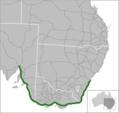
- For bypassed sections of the Princes Highway, see the following: Princes Highway, Sydney, Princes Highway, Wollongong, Old Princes Highway, Victoria, Princes Highway, Melbourne, and Princes Highway, Geelong.
The Princes Highway extends from Sydney to Port Augusta via the coast through the states of New South Wales, Victoria and South Australia, a distance of 1941 km (along Highway 1)[citation needed] or 1898 km via the former alignments of the highway[citation needed]. (However, that route is slower and there are many poor connections to the bypassed sections of the original alignment). The highway follows the coastline for most of its length and thus takes quite an indirect and lengthy route. By contrast, the Hume Highway (National Highway 31) from Sydney to Melbourne at 870 km (as opposed to 1040 km on Highway 1), and the Western and Dukes Highways (National Highway 8) from Melbourne to Adelaide at 730 km (915 km along Highway 1) are far more direct. Because of the rural nature and lower traffic volumes over much of its length, the Princes Highway is a more scenic and leisurely route than the main highways between these major cities.
Contents
History
The Princes Highway as a named route came into being when pre-existing roads were renamed ‘Prince's Highway’ after the visit to Australia in 1920 of the Prince of Wales (later to become King Edward VIII and, after abdicating, the Duke of Windsor).
The original submissions in January 1920 were in order for the Prince to have the opportunity during his visit to make the trip from Melbourne to Sydney overland along the route. Different routes were considered, including the inland route via Yass. [2] This idea never came to fruition, due partly to the limited amount of time and the cost to construct the road to a suitable standard for him to undertake the trip. The Prince did, however, give his permission for the naming. [3]
The highway had opening ceremonies in both New South Wales and Victoria during 1920. The first section of road from Melbourne was opened on 10 August in Warragul. [4] The road from Sydney was opened on 19 October in Bulli, by the NSW Minister for Local Government, Thomas Mutch.[5]
The approval was given by the Victorian executive to extend the highway west from Melbourne through Geelong, Camperdown, Warrnambool and Portland to the South Australian border in January 1922. [6] The roads were renamed by the South Australian government from Adelaide east to the South Australian border in February 1922. [7]
Route
New South Wales
See also: Princes Highway, Sydney and Princes Highway, Wollongong Princes Highway at Moruya, New South Wales.
 Princes Highway at Eden, NSW.
The Princes Highway starts at the junction of Broadway (Great Western Highway) and City Road (Princes Highway) in the Sydney suburb of Chippendale, and runs through Sydney's southern suburbs, to the village of Waterfall via Kogarah, Sutherland and Engadine.
After Waterfall the highway is paralleled by the Southern Freeway (national route 1) to the top of Bulli Pass outside the city of Wollongong. The highway then enters Wollongong and the Illawarra region, whilst Mount Ousley Road, which is designated as part of national route 1, bypasses Wollongong's northern suburbs. Where Mount Ousley Road enters Wollongong, the Southern Freeway resumes, and parallels the highway through the suburbs of Wollongong to Yallah.
From the southern end of the Southern Freeway at Yallah, the highway is dual carriageway to Kiama Heights (with the exception of the 3 km section from the Illawarra Highway to Tongarra Road, which is four lane undivided. Beyond Kiama Heights, 120 km south of Sydney, the highway is single two lane carriageway to Bomaderry, from where it is four lane divided through Bomaderry and Nowra. A 6 km length at South Nowra is to be duplicated to four lanes by 2012, and beyond this is another 4 km of four lane single carriageway. From this point the highway is mostly single two lane carriageway along the South Coast of New South Wales, passing through Ulladulla, Batemans Bay, Moruya, Narooma and Bega, then bypassing Merimbula and passing through Eden, before crossing the border into Victoria, 550 km from Sydney and 515 km from Melbourne.
The Princes Highway is considered a dangerous road by the New South Wales NRMA,[8] with 10 fatalities and 729 people injured on the highway between Sydney and the state border in 2006.[9]
Victoria
See also: Princes Freeway, Princes Highway, Melbourne, Princes Highway, Geelong, and Old Princes Highway, Victoria The Princes Highway is beautified in some towns, such as Bairnsdale, Victoria, where the median strip has been made a garden.
In Victoria the highway passes through Orbost, Bairnsdale and Sale in the Gippsland region. After the Latrobe Valley, much of the highway has been superseded by freeway, with the final sections of freeway scheduled for completion in 2010. From here the highway continues west to Dandenong and into the south-eastern suburbs of Melbourne.
As the road passes through Melbourne, it first becomes Lonsdale Street (through Dandenong), then Dandenong Road to St Kilda, then Queens Road through Albert Park (this section of highway is shown in the 1969 Melbourne Transportation Plan as part of the F14 freeway corridor). Closer to Melbourne city centre, the road's name becomes Kings Way, and then King Street in central Melbourne. The name changes to Curzon Street after leaving the central business district to enter North Melbourne, and then follows Flemington Road west from where it meets Curzon Street, then Racecourse Road, Smithfield Road and Ballarat Road, in that order, before it starts again as Geelong Road where Geelong Road branches off Ballarat Road and Ballarat Road becomes the Western Freeway. This reason for this confusing naming of the highway is that it follows streets and roads which were already named when the highway was named in 1920 and which were not renamed.
Through Melbourne and its suburbs the route of National Route 1 is not the Princes Highway, but rather the Monash Freeway, which intersects the Princes Highway on the eastern outskirts of Melbourne, and then the West Gate Freeway which bypasses central Melbourne. These two freeways have been linked by the southern link of the CityLink tollway. This avoids the confusing and congested arrangement of roads that is the Princes Highway in central Melbourne.
Heading towards Geelong in a south-west direction, the West Gate Freeway and Geelong Road join together in a junction to become the Princes Freeway, which, unusually for an Australian intercity freeway, carries enough traffic to merit three lanes in either direction. On the northern outskirts of Geelong, the highway reverts from freeway to three lane dual carriageway through Geelong and its suburbs, with traffic light-controlled at-grade intersections. Through Geelong the highway is often heavily congested. With the recent completion of the Geelong Ring Road, the M1 now travels on freeway-standard road from Geelong to Traralgon without encountering any traffic lights (with the exception of Yarragon and Trafalgar, which are yet to be bypassed). The ring road rejoins the highway at Waurn Ponds on the western edge of Geelong.
After Geelong the highway heads in a generally western direction and is mostly a single two lane carriageway. In May 2008 the Victorian and Federal Governments each committed $110 million to duplicate the Princes Highway from the Geelong Ring Road to Winchelsea.[10]
After Winchelsea the highway passes through Colac, before reaching Warrnambool. The section from Geelong to Warrnambool runs inland, and so avoids the slower, but scenic Great Ocean Road. From Warrnambool, the Princes Highway passes through Portland before crossing the border into South Australia. At this point the highway is 1530 km from Sydney, 465 km from Melbourne and 510 km from Adelaide.
South Australia
At Mount Gambier the highway takes a more northward tack as the coast curves to the northwest, passing the Coorong National Park. After Robe, it turns inland (north) to avoid the lakes at the mouth of the River Murray. Shortly before Tailem Bend it is joined by the Dukes Highway, part of the main route between Melbourne and Adelaide. The highway then turns north-west and becomes the South Eastern Freeway, crosses the Murray River, bypasses Murray Bridge and continues to Crafers where it becomes the Adelaide–Crafers Highway until Glen Osmond on Adelaide's southeastern outskirts. At this point the Princes Highway is 6 km from Adelaide and 2055 km from Sydney. It continues north-west via Glen Osmond Road to the Adelaide city centre where it turns north and follows the Main North Road to the Port Wakefield Road where it rejoins the coast. From Port Wakefield it resumes the name "Princes Highway", and follows the coast to Port Augusta where it terminates at the start of the Eyre Highway.
See also
- Highway 1 (Australia)
- Highways in Australia
- Highways in Victoria
- List of highways in New South Wales
- List of highways in South Australia
- A1 highway (South Australia)
References
- ^ Alpha-Numeric Route Numbering for NSW. It is here!, Ozroads: the Australian Roads Website. Retrieved on 9 January 2011.
- ^ "MELBOURNE-SYDNEY ROAD.". The Argus (Melbourne, Vic. : 1848 - 1956) (Melbourne, Vic.: National Library of Australia): p. 18. 24 January 1920. http://nla.gov.au/nla.news-article1674511. Retrieved 8 September 2011.
- ^ "PRINCE'S HIGHWAY.". The Argus (Melbourne, Vic. : 1848 - 1956) (Melbourne, Vic.: National Library of Australia): p. 9. 11 August 1920. http://nla.gov.au/nla.news-article4590839. Retrieved 8 September 2011.
- ^ "PRINCE'S HIGHWAY.". The Argus (Melbourne, Vic. : 1848 - 1956) (Melbourne, Vic.: National Library of Australia): p. 9. 11 August 1920. http://nla.gov.au/nla.news-article4590839. Retrieved 8 September 2011.
- ^ "PRINCE'S HIGHWAY.". The Sydney Morning Herald (NSW : 1842 - 1954) (NSW: National Library of Australia): p. 12. 20 October 1920. http://nla.gov.au/nla.news-article16871309. Retrieved 8 September 2011.
- ^ "PRINCE'S HIGHWAY.". The Argus (Melbourne, Vic. : 1848 - 1956) (Melbourne, Vic.: National Library of Australia): p. 12. 25 January 1922. http://nla.gov.au/nla.news-article4711162. Retrieved 8 September 2011.
- ^ "THE PRINCE'S HIGHWAY.". The Register (Adelaide, SA : 1901 - 1929) (Adelaide, SA: National Library of Australia): p. 6. 10 February 1922. http://nla.gov.au/nla.news-article63702785. Retrieved 8 September 2011.
- ^ "Princes Highway ignored by NSW govt: NRMA". ABC News (Australian Broadcasting Corporation). 22 June 2007. http://www.abc.net.au/news/stories/2007/06/22/1959177.htm. Retrieved 5 February 2008. "NRMA managing director Alan Evans says the highway is one of the most dangerous in the state and he is disappointed that it has been ignored."
- ^ "Road traffic crashes in New South Wales: Statistical Statement for the year ended 31 December 2006" (pdf). Crash statistics. New South Wales Road Traffic Authority. 2007. http://rta.nsw.gov.au/roadsafety/downloads/accidentstats2006.pdf. Retrieved 5 February 2008. (see Table 25: pages 58-59)
- ^ Jeff Whalley (9 May 2008). "Ring road will be connected to duplicated Princes Highway". Geelong Advertiser. www.geelongadvertiser.com.au. http://www.geelongadvertiser.com.au/article/2008/05/09/13757_news.html. Retrieved 18 July 2008.
External links
 Road Infrastructure in Adelaide
Freeways Adelaide–Crafers Highway · Port River Expressway · South Eastern Freeway · Southern Expressway · Northern Expressway · Northern Connector (proposed) · South Road Superway (proposed) · North-South Corridor (proposed)
Highways and major roads Anzac Highway · Gawler Bypass Road · Glen Osmond Road · Grand Junction Road · Main North Road · Main South Road · Mount Barker Road · North East Road · Port Wakefield Road · Portrush Road · Salisbury Highway · Sir Donald Bradman Drive · South RoadOther roads City Ring Route · Cross Road · Daws Road · Fullarton Road · Goodwood Road · Greenhill Road · Hampstead Road · Kensington Road · Kings Road · McIntyre Road · Magill Road · Marion Road · Montacute Road · Montague Road · Tapleys Hill Road · The Parade · Regency Road · Torrens Road · Victoria RoadCity streets Grote Street · King William Street · Morphett Street · North Terrace · Pulteney Street · Wakefield Street · West TerraceTransport in Adelaide  Road infrastructure in Melbourne
Tollways Freeways Airport Drive • Calder Freeway • Eastern Freeway • Frankston Freeway • Hume Freeway • Metropolitan Ring Road • Monash Freeway • Mornington Peninsula Freeway • Princes Freeway • South Gippsland Freeway • Tullamarine Freeway • West Gate Freeway • Western Freeway • Western Ring RoadHighways Ballarat Road • Bell Street • Bulleen Road • Burwood Highway • Chandler Highway • Dandenong Road • Dandenong Valley Highway • Eastern Highway • Flemington Road • Geelong Road • Greensborough Highway • Hoddle Highway • Maroondah Highway • Melton Highway • Moorooduc Highway • Mountain Highway • Nepean Highway • Plenty Valley Highway • Springvale Road • St Kilda Road • Sydney Road • Warrigal Road • Westall Road • Western Port Highway • Whitehorse RoadBypasses Dandenong Bypass • Ringwood Bypass • Westall Road (Springvale Bypass)Bridges and tunnels Bolte Bridge • Burnley Tunnel • Domain Tunnel • Melba Tunnel • Mullum Mullum Tunnel • West Gate BridgeUnder construction Peninsula Link • Dingley ArterialProposals 1969 Melbourne Transportation Plan • East-West Link • Outer Ring Road • Dingley Arterial • Healesville Freeway • Koo Wee Rup Bypass • Mornington Peninsula Freeway • North East LinkStreets in Melbourne • Highways in Melbourne • VicRoads • Transport in Melbourne Road infrastructure in South AustraliaFreeways Interstate Highways Barrier Highway • Dukes Highway • Eyre Highway • Port Wakefield Road • Princes Highway • Stuart Highway • Sturt HighwayState Highways Roads Adelaide Mannum Road • Gorge Road • Macclesfield Road • Onkaparinga Valley Road • Main South Road • Strathalbyn-Goolwa Road • Wellington RoadOutback Tracks Road infrastructure in VictoriaFreeways Highways Bass Highway • Bellarine Highway • Borung Highway • Calder Highway • Glenelg Highway • Goulburn Valley Highway • Hamilton Highway • Henty Highway • Hopkins Highway • Kiewa Valley Highway • Loddon Valley Highway • Mallee Highway • Maroondah Highway • Melba Highway • Midland Highway • Monaro Highway • Murray Valley Highway • Nepean Highway • Northern Highway • Omeo Highway • Princes Highway • Pyrenees Highway • South Gippsland Highway • Strzelecki Highway • Sturt Highway • Sunraysia Highway • Surf Coast Highway • Warburton Highway • Western Highway • Western Port Highway • Wimmera HighwayBypass routes Old Hume Highway • Old Princes Highway • Princes Highway (Geelong)Tourist routes Categories:- 1920 establishments in Australia
- Highways and freeways in Melbourne
- Highways in Victoria (Australia)
- Transport in Geelong
- Highways in South Australia
- Highways in New South Wales
- Streets in Sydney


Wikimedia Foundation. 2010.