- Châtelet (Paris Métro)
-
Châtelet 
Date opened 19 July 1900 Accesses - Rue des Lavandières × Rue de Rivoli
- Pl. Marguerite de Navarre
- 55, rue de Rivoli
- 63/65, rue de Rivoli
- 112, rue de Rivoli
- 7, av. Victoria
- 15, av. Victoria
- 16, av. Victoria
- 5, rue Saint-Denis
- 8, pl. Sainte-Opportune
- Pl. du Châtelet
Municipality/
Arrondissementthe 1st arrondissement of Paris Coordinates 48°51′30″N 2°20′50″E / 48.858352°N 2.347324°ECoordinates: 48°51′30″N 2°20′50″E / 48.858352°N 2.347324°E Fare zone 1 Next stations Paris Métro Line 1 Direction
La DéfenseDirection
Château de VincennesLouvre – Rivoli Hôtel de Ville Paris Métro Line 4 Direction
Porte de ClignancourtDirection
Porte d'OrléansLes Halles Cité Paris Métro Line 7 Direction
Villejuif or
Mairie d'IvryDirection
La Courneuve – 8 Mai 1945Pont Marie Pont Neuf Paris Métro Line 11 Direction
ChâteletDirection
Mairie des LilasTerminus Hôtel de Ville Paris Métro Line 14 Direction
Saint-LazareDirection
OlympiadesPyramides Gare de Lyon Connections to other stations Châtelet – Les Halles (RER A, B, D)
Les Halles (4)List of stations of the Paris Métro 
 Location of metro station
Châtelet is a station on lines 1, 4, 7, 11 and 14 of the Paris Métro in the centre of medieval Paris and the 1st arrondissement. The station is made up of two parts connected by a long corridor:
- lines 7 and 11 under the Place du Châtelet and the Quai de Gesvre (site of the original medieval river port of Paris), next to the Seine;
- lines 1, 4 and 14 towards Rue Saint-Denis and the Rue de Rivoli.
Châtelet is connected by another long underground corridor to the southern end of the RER station Châtelet – Les Halles, the northern end of which is again connected to the Métro station Les Halles. The walking distance from Line 7 at Châtelet to the RER lines at Châtelet – Les Halles is circa 750 metres.
Contents
History
 Station layout
 Grand Châtelet demolished in 1802
The station was opened on 6 August 1900, three weeks after trains began running on the original section of line 1 between Porte de Vincennes and Porte Maillot on 19 July 1900. The line 4 platforms were opened on 21 April 1908 as part of the original section of the line from Porte de Clignancourt to Châtelet. It was the southern terminus of line 4 until the opening of the connecting section of the line under the Seine to Raspail on 9 January 1910.
The line 7 platforms were opened on 16 April 1926 as part of the line's extension from Palais Royal to Pont Marie with the name Pont Notre-Dame-Pont au Change. It had no direct connection with Châtelet. On 15 April 1934 a connecting corridor was opened to the platforms of lines 1 and 4 and the line 7 station was renamed. The line 11 platforms were opened near the line 7 platforms on 28 April 1935 as part of the original section of the line from Châtelet to Porte des Lilas.
On 9 December 1977 the Châtelet – Les Halles RER station was opened with a connecting corridor with a moving walkway to Châtelet. The line 14 platforms were opened near the line 1 and 4 platforms on 15 October 1998 as part of the original section of the line from Madeleine to Bibliothèque François Mitterrand. On 7 and 8 March 2009 the line 1 platforms were restored during the automation of line 1, including the installation of platform screen doors.
It is named after the Place du Châtelet, which is named after the Grand Châtelet, a castle over the northern approach to the old Pont au Change over the Seine to the Île de la Cité, which was demolished by Napoléon in 1802. Châtelet is a medieval French term for barbican, a small castle that commands (overlooks) a bridge or defile.[1]
Gallery
-

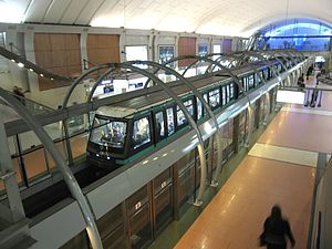
Line 14
See also
Notes
- ^ Jacques Hillairet, Dictionnaire historique des rues de Paris, 8th ed. (Éditions de Minuit, 1985), Vol. 1, pp. 331–34.
Paris Métro Line 7 La Courneuve — 8 Mai 1945

 • Fort d'Aubervilliers • Aubervilliers — Pantin — Quatre Chemins • Porte de la Villette • Corentin Cariou • Crimée • Riquet • Stalingrad

 • Louis Blanc
  • Château-Landon • Gare de l'Est
  • Poissonnière • Cadet • Le Peletier • Chaussée d'Antin — La Fayette
  • Opéra


 • Pyramides
  • Palais Royal — Musée du Louvre
  • Pont Neuf • Châtelet

 • Pont Marie • Sully — Morland • Jussieu
  • Place Monge • Censier Daubenton • Les Gobelins • Place d'Italie
  • Tolbiac • Maison Blanche
 South branch
Le Kremlin-Bicêtre • Villejuif — Léo Lagrange • Villejuif — Paul Vaillant-Couturier • Villejuif — Louis AragonSoutheast branch
Porte d'Italie  • Porte de Choisy • Porte d'Ivry • Pierre et Marie Curie • Mairie d'Ivry
Paris Métro Line 11 Châtelet
 • Hôtel de Ville • Rambuteau • Arts et Métiers • République • Goncourt • Belleville • Pyrénées • Jourdain • Place des Fêtes • Télégraphe • Porte des Lilas
  • Mairie des Lilas
Paris Métro Line 14 Saint-Lazare


 · Madeleine · Pyramides · Châtelet · Gare de Lyon · Bercy · Cour Saint-Émilion · Bibliothèque François Mitterrand
  · OlympiadesCategories:
- Paris Métro line 1
- Paris Métro line 4
- Paris Métro line 7
- Paris Métro line 11
- Paris Métro line 14
- Paris Métro stations in the 1st arrondissement of Paris
- Paris Métro stations in the 4th arrondissement of Paris
- Railway stations opened in 1900


Wikimedia Foundation. 2010.