- New York State Route 43
-
"NY 43" redirects here. NY 43 may also refer to New York's 43rd congressional district.
NYS Route 43
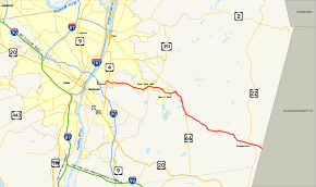
Map of the Albany area with NY 43 highlighted in redRoute information Maintained by NYSDOT Length: 24.00 mi[3] (38.62 km) Existed: 1920s[1][2] – present Major junctions West end:  I-90 in North Greenbush
 NY 66 in Sand Lake
 NY 22 in Stephentown
East end:  Route 43 at Stephentown
Location Counties: Rensselaer Highway system Numbered highways in New York
Interstate • U.S. • N.Y. (former) • Reference • County←  NY 42
NY 42US 44  →
→New York State Route 43 (NY 43) is a state highway in Rensselaer County, New York, United States. It extends for 24.00 miles (38.62 km) from Interstate 90 (I-90) exit 8 in North Greenbush to the Massachusetts state line, where it continues into Williamstown as Massachusetts Route 43. Most of NY 43 is a two-lane highway that passes through a mixture of rural and residential areas; however, its westernmost 2 miles (3.2 km) between I-90 and U.S. Route 4 (US 4) is a four-lane divided highway. NY 43 has an overlap with NY 66 in Sand Lake and intersects NY 22 in Stephentown.
When NY 43 was first assigned in the 1920s, it began near the village of Schoharie and ended in downtown Albany. Initially, the portion of modern NY 43 east of Averill Park was designated as part of New York State Route 7 in 1924. It was renumbered to New York State Route 45 by 1926 and became part of an extended NY 43 as part of the 1930 renumbering of state highways in New York. NY 43 was originally routed on Broadway and Washington Avenue in Rensselaer; however, it was rerouted to use 3rd Avenue and US 4 instead in the late 1960s.
In the early 1970s, the route was truncated to consist only of the portion east of the Hudson River. NY 43's former routing west to Schoharie was redesignated NY 443 as a result. NY 43 was realigned slightly in the late 1990s to serve the new exit 8 on I-90. Its former routing into Rensselaer on 3rd Avenue is now partly NY 151 and unsigned NY 915E.
Contents
Route description
NY 43 begins at an interchange with I-90 (exit 8) in the town of North Greenbush in western Rensselaer County. The route heads northeastward as a four-lane divided highway through a small forest separating NY 43 from a pair of residential neighborhoods. NY 43 provides access to these neighborhoods at an intersection with Washington Avenue. Past this junction, the highway turns eastward to meet US 4 in the hamlet of Defreestville. NY 43 narrows to two lanes roughly 0.25 miles (0.40 km) east of US 4 and continues eastward through a densely populated area of North Greenbush.[4]
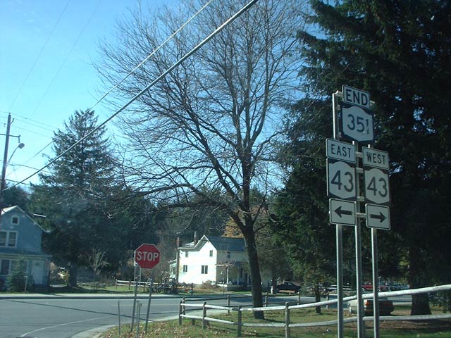
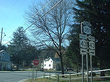 Junction of NY 43 and NY 351 in Sand Lake as viewed from NY 351 southbound
East of Lape Road (County Route 66 or CR 66), the amount of development along NY 43 begins to decline and give way to small, open fields located amongst forested areas. However, as NY 43 enters the town of Sand Lake, the number of homes and businesses on the highway rises once more. The level of development reaches its greatest point in West Sand Lake, a community centered around NY 43's junction with NY 150. NY 43 continues on, passing through residential areas of Sand Lake as it intersects NY 351 and heads eastward to Averill Park. The route meets NY 66 east of the community, and the two routes overlap for 3 miles (5 km) southeastward along the eastern shores of the small Glass and Crooked Lakes. NY 43 and NY 66 split just after crossing into the town of Nassau near the southern edge of Crooked Lake.[4]
NY 43 heads southeastward from NY 66, passing through mostly rural, forested areas as it proceeds toward the Massachusetts state line. Most of the development along the final stretch of the route is concentrated in the small communities along the route. It passes through Dunham Hollow and enters the town of Stephentown as it serves the hamlet of West Stephentown. NY 43 continues through forested areas of Stephentown to Stephentown Center, denoted by a cluster of homes near the intersection of NY 43 and Newton Road.[4]
From Stephentown Center, the route heads southeast to the community of Stephentown situated 2 miles (3.2 km) west of the state line. NY 43 serves as the main commercial strip through the hamlet, which is the largest location on the route since Averill Park. Here, NY 43 intersects NY 22 at a junction that features sharp corners for commuters turning onto NY 43 from NY 22. Past NY 22, NY 43 heads southeast through mostly open fields and lightly populated areas to the Massachusetts state line, where the roadway becomes Route 43 upon crossing into Williamstown, Massachusetts.[4]
History
Origins and designation
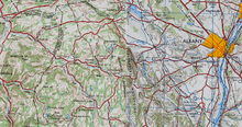 Late 1940s map of NY 43's former routing west of Albany
In 1908, the New York State Legislature created a system of unsigned legislative routes across the state of New York. Two of the routes created at this time were Route 7, which extended from the Pennsylvania state line south of Binghamton to Albany via Oneonta, Cobleskill[disambiguation needed
 ], Berne, and New Scotland, and Route 24, a highway extending from the east bank of the Hudson River in Rensselaer to the Massachusetts state line near Mount Lebanon by way of Averill Park and Nassau. In the vicinity of Rensselaer, Route 21 was routed on 3rd Avenue, 3rd Avenue Extension, North Greenbush Road, and West Sand Lake Road.[5][6]
When the first set of posted routes in New York were assigned in 1924, a highway connecting Route 21 in Averill Park to the Massachusetts state line at Stephentown was designated as part of NY 7, a route that continued northwest from Averill Park to Troy on modern NY 66.[1] By 1926, the portion of old legislative Route 7 from Central Bridge to East Berne was designated as part of NY 43, a new route extending from Central Bridge to downtown Albany via East Berne, Clarksville, and Delmar,[2] while NY 7 was renumbered to NY 45.[7]
Changes in routing
In the 1930 renumbering of state highways in New York, NY 43 was truncated slightly on its western end to begin at a junction with the new NY 30 north of Schoharie. Meanwhile, NY 45 was reassigned to another highway in Orange County. The portion of former NY 45 from Troy to Averill Park became part of NY 66 while the remainder became an eastward extension of NY 43. The extended NY 43 was now concurrent with US 9 and US 20 along Madison Avenue from Delaware Avenue to Rensselaer, where it followed Broadway and Washington Avenue to US 4 in Defreestville. The route continued east to Averill Park on what had been legislative Route 21.[8][9]
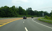 Approaching US 4 on NY 43 eastbound in North Greenbush
NY 43 was extended slightly following the construction of a new alignment for NY 30 near Central Bridge in the early 1940s. NY 30 now left its old alignment southeast of Central Bridge and bypassed the community to the east.[10][11] The former routing of NY 30 into Central Bridge became an extension of NY 43, which overlapped NY 30 between the new alignment and Schoharie.[12] When NY 30A replaced NY 148 in the late 1950s, the short piece of NY 43 near Central Bridge became part of NY 30A and NY 43 was truncated back to NY 30 near Schoharie.[13][14] In the late 1960s, NY 43 was rerouted through downtown Rensselaer to follow 3rd Avenue (previously NY 381) east to US 4. From there, NY 43 overlapped US 4 northward to Defreestville, where it rejoined its previous alignment.[15][16]
NY 43 was truncated on its western end to the junction of 3rd Avenue and Broadway in downtown Rensselaer in the early 1970s, eliminating the overlap with US 9 and US 20 through Albany. Its former routing from Schoharie to Albany was renumbered to NY 443.[16][17] NY 43 remained on 3rd Avenue up to the late 1990s when it was rerouted to follow a new highway to I-90 exit 8 west of Defreestville. The realignment eliminated the overlap with US 4 and also took NY 43 outside of the Rensselaer city limits for the first time since being extended across the Hudson River in 1930.[18][19] The former alignment of NY 43 along 3rd Street from Broadway to Barracks Road became part of NY 151;[19] the remainder was designated NY 915E, an unsigned reference route.[20]
Major intersections
The entire route is in Rensselaer County.
Location Mile[3] Destinations Notes North Greenbush 0.00 I-90Exit 8 (I-90) 1.85  US 4 (North Greenbush Road)
Sand Lake 6.59  NY 150 (West Sand Lake Road)
Hamlet of West Sand Lake 7.25  NY 351 (Reichard Lake Road)
Southern terminus of NY 351 10.44 NY 66 north (Miller Hill Road)Western terminus of NY 43 / NY 66 overlap Town of Nassau 13.40 NY 66 southEastern terminus of NY 43 / NY 66 overlap Stephentown 22.45 NY 2224.00 Route 43Continuation into Massachusetts 1.000 mi = 1.609 km; 1.000 km = 0.621 mi References
- ^ a b "New York's Main Highways Designated by Numbers". The New York Times: p. XX9. December 21, 1924.
- ^ a b Rand McNally and Company (1926). Rand McNally Auto Road Atlas (eastern New York) (Map). http://www.broermapsonline.org/members/NorthAmerica/UnitedStates/Midatlantic/NewYork/unitedstates1926ra_009.html. Retrieved June 19, 2009.
- ^ a b "2008 Traffic Data Report for New York State" (PDF). New York State Department of Transportation. June 16, 2009. p. 191. https://www.nysdot.gov/divisions/engineering/technical-services/hds-respository/NYSDOT_Traffic_Data_Report_2008.pdf. Retrieved December 8, 2009.
- ^ a b c d Yahoo! Inc. Yahoo! Maps – overview map of NY 43 (Map). Cartography by NAVTEQ. http://maps.yahoo.com/#mvt=h&lat=42.615953&lon=-73.547794&zoom=13&q1=42.65653%2C-73.719648&q2=42.636604%2C-73.539382&q3=42.539304%2C-73.341671. Retrieved June 19, 2009.
- ^ State of New York Department of Highways (1909). The Highway Law. Albany, New York: J. B. Lyon Company. pp. 57, 61. http://books.google.com/books?id=jZ0AAAAAMAAJ&pg=PA57. Retrieved June 19, 2009.
- ^ New York State Department of Highways (1920). Report of the State Commissioner of Highways. Albany, New York: J. B. Lyon Company. pp. 513–515, 530. http://books.google.com/books?id=Sj4CAAAAYAAJ&pg=PA513. Retrieved June 19, 2009.
- ^ Rand McNally and Company (1926). Rand McNally Auto Road Atlas (southern New England) (Map). http://www.broermapsonline.org/members/NorthAmerica/UnitedStates/NewEngland/unitedstates1926ra_006.html. Retrieved June 19, 2009.
- ^ Dickinson, Leon A. (January 12, 1930). "New Signs for State Highways". The New York Times: p. 136.
- ^ Standard Oil Company of New York (1930). Road Map of New York (Map). Cartography by General Drafting.
- ^ Esso (1940). New York (Map). Cartography by General Drafting.
- ^ Esso (1942). New York with Pictorial Guide (Map). Cartography by General Drafting.
- ^ Esso (1954). New York with Special Maps of Putnam–Rockland–Westchester Counties and Finger Lakes Region (Map). Cartography by General Drafting (1955–56 ed.).
- ^ Esso (1958). New York with Special Maps of Putnam–Rockland–Westchester Counties and Finger Lakes Region (Map). Cartography by General Drafting (1958 ed.).
- ^ Gulf (1960). New York and New Jersey Tourgide Map (Map). Cartography by Rand McNally and Company.
- ^ Esso (1968). New York (Map). Cartography by General Drafting (1969–70 ed.).
- ^ a b State of New York Department of Transportation (January 1, 1970) (PDF). Official Description of Touring Routes in New York State. http://www.greaternyroads.info/pdfs/state70.pdf. Retrieved June 19, 2009.
- ^ Shell Oil Company (1973). New York (Map). Cartography by H.M. Gousha Company (1973 ed.).
- ^ Rand McNally (1995). New York (Map). ISBN 0-528-96764-9.
- ^ a b Rand McNally (1998). Rand McNally Road Atlas (Map). p. 67. ISBN 0-528-83935-7.
- ^ New York State Department of Transportation (October 2004) (PDF). Official Description of Highway Touring Routes, Scenic Byways, & Bicycle Routes in New York State. https://www.nysdot.gov/divisions/operating/oom/transportation-systems/repository/tour_route_0.pdf. Retrieved June 19, 2009.
External links
Categories:- State highways in New York
- Transportation in Rensselaer County, New York


Wikimedia Foundation. 2010.