- Colonel Fabien (Paris Métro)
-
Colonel Fabien 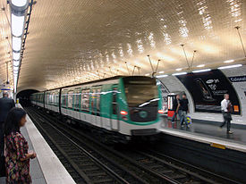
Date opened 31 January 1903 Accesses 83, boul. de la Villette Municipality/
Arrondissementthe 10th arrondissement of Paris Fare zone 1 Next stations Paris Métro Line 2 Direction
Porte DauphineDirection
NationJaurès Belleville List of stations of the Paris Métro 
 Location of metro station
Colonel Fabien is a station on Paris Métro Line 2, on the border of the 10th and 19th arrondissements under the Boulevard de la Vilette.
The station was opened on 31 January 1903 as part of the extension of line 2 from Anvers to Bagnolet (now called Alexandre Dumas). It was originally named Combat after the Place de la Combat, which was named after the Barrière de la Combat, a gate built for the collection of taxation as part of the Wall of the Farmers-General; the gate was built between 1784 and 1788 and demolished after the Paris Commune of 1871. Its name reflected the animal fighting held there between 1778 and 1850. On 19 August 1945 the Place and station were renamed after Colonel Pierre-Georges Fabien, who shot a German soldier to death at Barbès – Rochechouart metro station, marking the beginning of the armed French Resistance in Paris.
Layout
Side Platform 
 towards Porte Dauphine towards Nation
Side Platform Paris Métro Line 2 Porte Dauphine • Victor Hugo • Charles de Gaulle — Étoile


 • Ternes • Courcelles • Monceau • Villiers
  • Rome • Place de Clichy
  • Blanche • Pigalle
  • Anvers • Barbès — Rochechouart
  • La Chapelle ⇒
 • Stalingrad
 • Jaurès
  • Colonel Fabien • Belleville
  • Couronnes • Ménilmontant • Père Lachaise • Philippe Auguste • Alexandre Dumas • Avron • Nation
Coordinates: 48°52′38″N 2°22′16″E / 48.877136°N 2.37116°EThis article related to the Paris Métro is a stub. You can help Wikipedia by expanding it.
