- Maidenhead Locator System
-
The Maidenhead Locator System is a geographic coordinate system used by amateur radio operators. Dr. John Morris, G4ANB, originally devised the system, and a group of VHF managers, meeting in Maidenhead, England in 1980, adopted it. The Maidenhead Locator System supplants the older QRA locator system with one that is usable outside of Europe.
Maidenhead locators are also commonly referred to as grid locators or grid squares, despite having a non-square shape on any non-equirectangular cartographic projection.
Description of the system
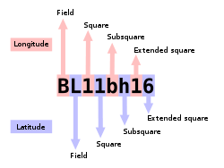
A Maidenhead locator compresses latitude and longitude into a short string of characters. This position information is presented in a limited level of precision in order to limit the amount of characters needed for its transmission using voice, Morse code, or any other operating mode.
The chosen coding uses alternating pairs of letters and digits, like so:
-
-
- BL11bh16
-
In each pair, the first character encodes longitude and the second character encodes latitude. These character pairs also have traditional names, and in the case of letters, the range of characters (or "encoding base number") used in each pair does vary.
In order to avoid negative numbers in the input data, the system also specifies that latitude is measured from the South Pole to the North Pole, and longitude measured eastward from the antimeridian of Greenwich, giving the Prime Meridian a false easting of 180° and the equator a false northing of 90°.
To simplify manual encoding, the base for the first pair of letters—traditionally called a field—was chosen to be 18, thus dividing the globe into 18 zones of longitude of 20° each, and 18 zones of latitude 10° each. These zones are encoded with the letters "A" through "R".
 The world is divided into 324 (18²) Maidenhead fields.
The first pair of numbers, called a square and placed after the first pair of letters, uses a base number of 10, and is encoded using the digits "0" to "9". This is where the alternative name "grid squares" comes from. Each of these squares represents 1° of latitude by 2° of longitude.
For additional precision, each square can optionally be sub-divided further, into subsquares. These are encoded into a second pair of letters, often (but not always) presented in lowercase, and again, to make manual calculations from degrees and minutes easier, 24 was chosen as the base number, giving these subsquares dimensions of 2.5' of latitude by 5' of longitude. The letters used are "A" through "X".
The resulting Maidenhead subsquare locator string is hence composed of two letters, two digits, and two more letters. To give an example, W1AW, the American Radio Relay League's Hiram Percy Maxim Memorial Station in Newington, Connecticut, is found in grid locator FN31pr. Two points within the same Maidenhead subsquare are always less than 12 km apart, which means a Maidenhead locator can give significant precision from just six easily transmissible characters.
 Fields are divided into 100 squares each.
For even more precise location mapping, two additional digits were proposed and ratified as an extended locator, making it altogether eight characters long, and dividing subsquares into even smaller ones. Such precision has uses in very short communication spans. Beyond this, no common definition exists to extend the system further into even smaller squares. Most often the extending is done by repeating alternating subsquare and square rules (base numbers 24 and 10 respectively). However, other bases for letter encodings have also been observed, and therefore such extended extended locators might not be compatible.
The Maidenhead locator system has been explicitly based on the WGS 84 geodetic datum since 1999. Before that time, it was usually based on each user's local national datum, which do differ slightly from one another and WGS 84. As a result, stations very near the edges of squares at denoted precision may have changed their locators when changing over to the use of WGS 84.
To summarize:
- Character pairs encode longitude first, and then latitude.
- The first pair (a field) encodes with base 18 and the letters "A" to "R".
- The second pair (square) encodes with base 10 and the digits "0" to "9".
- The third pair (subsquare) encodes with base 24 and the letters "A" to "X".
- The fourth pair (extended square) encodes with base 10 and the digits "0" to "9".
- The fifth and subsequent pairs are not formally defined, but recycling the third and fourth pair algorithms is one possible definition:
-
-
- BL11bh16oo66
-
On shortwave frequencies, positions are reported at square precision, and on VHF and UHF, subsquare precision is used. More precise position reports are very rarely used.
Use by radio amateurs
Today, individual radio amateurs and organizations around the world recognize and use Maidenhead locators. Many utilities exist to convert latitude and longitude to locators, as this is a favorite hack for programmers who are also radio amateurs. Commercially available (civil) Global Positioning System receivers are frequently able to display Maidenhead locators.
Maidenhead locators are used as part of the formulas for scoring in many VHF amateur radio contests. Grid locators are also the basis of earning many awards like the American Radio Relay League's VHF/UHF Century Club, URE TTLOC, etc. operating award.
In IARU Region 1 rules, VHF distance calculations are carried out between Maidenhead subsquare centers assuming a spherical Earth. This results in a small error in distance, but makes calculations simpler and, given the inherent imprecision in the used input data, it is not the biggest error source.
External links
- ARRLWeb: Grid Locators and Grid Squares
- ARRLWeb: Calculate Grid Square
- From the field hunter's web page: An explanation of the system and how it came into being.
- Maidenhead Grid Squares
- Find QTH locator or Maidenhead grid square, at arbitrary sub-level, and approximate distance and bearing between two squares
- Find QTH locator or Maidenhead grid square, at maximum 6 character level, and approximate distance and bearing between two squares
- Generate a KML file that outlines a grid position
Categories:- Amateur radio
- Maidenhead
- Geographic coordinate systems
-


Wikimedia Foundation. 2010.