- Northern Busway, Auckland
-
See also: Northern Busway, Brisbane
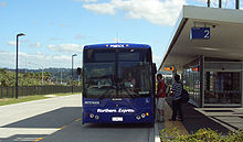 Passengers boarding a MAXX Regional Transport Northern Express service operated by Ritchies Coachlines.
The Northern Busway is a physically separated busway with dedicated park & ride facilities along State Highway 1 in the north of Auckland, New Zealand, linking the North Shore with Auckland CBD. It reduces travel times for from around one hour by car during peak hours to about half an hour by bus,[1] and within the North Shore, where it is to become the spine of an ambitious bus-based public transport system.
Contents
History
Construction
 Smales Farm station, shortly before the busway opening.
The project was designed and consulted on by Mario Madayag Architecture, Jasmax, Beca Group, Opus and Connell Wagner, while Fletcher Construction built the busway. Akoranga, Smales Farm, and Sunnynook stations were built by NZ Strong Construction.[2][3][4]
Difficulties encountered included the close-by residential areas, the predominantly soft ground, and environmental efforts to protect dotterel breeding grounds. The construction of the busway employed around 300 people at its peak, with around a million man-hours being invested, including shifts during 512 nights.[4][5]
Operation
The busway was officially opened in February 2008 after several years of construction, though the two northernmost stations had been operating since December 2005 using the normal Northern Motorway lanes.[6][7] It was credited with having reduced peak traffic on the Northern Motorway by around 500 cars each rush hour one month after the opening,[8] and about 39% of passengers on the 'Northern Express' bus service had never used public transport before.[4] The busway was initially used by 70 buses per hour during peak time,[5] which includes both existing and new services like the 'Northern Express'.
With its completion, the busway has started to raise interest both amongst technical experts as well as other groups. There have been advertisements filmed at the bus stations, and requests to allow filming of car commercials on the busway (a request denied as being inappropriate for a public transport facility) and interest from overseas movie location scouts wanting to use the 'futuristic' stations as backdrops.[9]
In 2008 the busway received the 'Shell Bitumen Excellence Award for a Major Roading Project' and the 'Roading New Zealand Supreme Award'.[10] In June 2009, it received the Ingenium 'Excellence Award' (in the category for projects above NZ$2 million construction cost).[11]
In June 2010, the busway carried its 5-millionth passenger. The patronage figures have kept rising, and as of 2010, the busway is estimated to remove the equivalent of about 5,100 cars in the morning peak from the route, with 80 buses per hour during the peak times.[12]
By mid 2011, frequencies of Northern Express buses had risen to one every three minutes during the morning peak hour, five minutes during the 'shoulder peak' hours.[13]
Funding
The busway became fully operational in 2009 (with some final sections being completed with little publicity) for a cost of around NZ$290–294 million: $210 million for the busway and $84 million for the stations.[14][15] The project was funded by Transit New Zealand, ARTA and the Auckland City Council and North Shore City Councils.[5]
Infrastructure
 Constellation Drive Park & Ride station.
Busway
The busway extends on two lanes for 6.2 km[16] running parallel with the motorway from Constellation Drive, Albany to Akoranga bus station,[17] from where a one-way southbound bus lane extends a further 2.5 km to the Harbour Bridge[4]
Its use is limited to buses of 25+ seat capacity, emergency and maintenance vehicles.[14] The busway has been designed for possible use by car pools[16] and for potential conversion to light rail.[18]
Bus stations
The busway includes five dedicated stations, some with extensive park & ride car parks. Feeder bus services serve the stations, allowing transfer or continuing on the busway.
The stations are (south to north):[2]
- Akoranga Busway Station
- Smales Farm Busway Station
- Sunnynook Busway Station
- Constellation Drive Park & Ride
- Albany Park & Ride
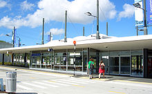
 Akoranga bus station. The footbridge leads to the western side of the motorway.
All stations provide shelter and cycle parking and were designed with public safety in mind, such as with glass walls, low planting, night lighting and CCTV to enhance security.[16]
Other structures
Major related structures are the new Esmonde Interchange (with the works also including large-scale improvements for other traffic modes), and the Tristram Avenue Viaduct, which crosses the often congested Tristram Avenue via grade separation. The viaduct has 12 spans of 30 m each, with the foundation piles being 1.5 m thick.[17]
Future plans
 Sunnynook station, the smallest of the five.
Future plans for the facility include the suggestion of extending rail across the Waitemata Harbour to the North Shore, via either a second bridge or a tunnel, as the busway design paramaters allow for later conversion to light rail[19] (but not, with the current design, to heavy rail).
An extension towards Orewa in the north is being debated for the long-term future. It was originally expected to cost around NZ$500 million,[15] although the success of the scheme has now sparked potentially more extensive schemes for between NZ$700 million and NZ$1.2 billion for an extension to at least Silverdale, with up to five tunnels and seven bridges, including a motorway flyover between Constellation Drive and Albany stations. New stations are proposed at Rosedale, Redvale and Silverdale.[20]
See also
- Public transport in Auckland
- Ritchies Coachlines, transport operator as of 2007
References
- ^ Rail electrification - Region Wide, Auckland Regional Council newsletter, June 2007, Page 3
- ^ a b Aerial Map (from the official project website)
- ^ North Shore Busways (from the NZ Strong Construction company website. Accessed 2008-03-03.)
- ^ a b c d Dedicated busway a roaring success - LG, New Zealand Local Government, March 2008, Volume 44 No 03
- ^ a b c Busway bits 'n' pieces - Region Wide, newsletter of the Auckland Regional Council, March 2008, Page 4
- ^ Northern Busway - The New Zealand Herald, Saturday 30 June 2007, Page C6
- ^ "Multi-million dollar busway opens". Television New Zealand. 2 February 2008. http://tvnz.co.nz/view/page/1568832. Retrieved 1 November 2011.
- ^ Busway reduces cars by 500 each rush hour - Region Wide, newsletter of the Auckland Regional Council, March 2008, Page 4
- ^ Dearnaley, Mathew (22 March 2008). "Busway creates interest overseas". The New Zealand Herald. http://www.nzherald.co.nz/transport/news/article.cfm?c_id=97&objectid=10499544. Retrieved 1 November 2011.
- ^ "Busway wins excellence award". The New Zealand Herald. 26 August 2008. http://www.nzherald.co.nz/transport/news/article.cfm?c_id=97&objectid=10528948. Retrieved 1 November 2011.
- ^ "Northern Busway wins award". The New Zealand Herald. 8 June 2009. http://www.nzherald.co.nz/nz/news/article.cfm?c_id=1&objectid=10577100. Retrieved 1 November 2011.
- ^ "Like a railway, but with buses". Region Wide. Auckland Regional Council: pp. 2. July 2010.
- ^ "Keeping our region moving". Our Auckland. Auckland Council. July 2011.
- ^ a b Welcome to the Northern Busway (from the official project website)
- ^ a b Following the money - e.nz magazine, IPENZ January/February 2007
- ^ a b c Frequently Asked Question (from the North Shore City Council website. Accessed 2008-03-21.)
- ^ a b Busway the way of the future for North Shore - LG, New Zealand Local Government, May 2007, Volume 43 No 05
- ^ Busway FAQ (from the North Shore City Council website. Accessed 2008-01-11.)
- ^ Rudman, Brian (11 July 2007). "Brian Rudman: Hallelujah, talk before bulldozers". The New Zealand Herald. http://www.nzherald.co.nz/opinion/news/article.cfm?c_id=466&objectid=10450782. Retrieved 1 November 2011.
- ^ Dearnaley, Mathew (13 November 2008). "Buzzing busway could get even bigger". The New Zealand Herald. http://www.nzherald.co.nz/transport/news/article.cfm?c_id=97&objectid=10542723. Retrieved 1 November 2011.
External links
- Northern Busway (official project website - archived version)
- SH1 Northern Busway (NZTA Official Project Page)
Bus transport in New Zealand Urban bus companies Go Bus Transport (Go Bus Christchurch) · NZ Bus (GOWest - Northstar - The Link - Metrolink - Waka Pacific - GOWellington - Valley Flyer) · Leopard Coachlines Ltd · Passenger Transport · Red Bus Ltd · Ritchies Transport · Souter Holdings (Howick & Eastern - Mana Coach Services - Newlands Coach Services)Long distance bus companies Tourism bus companies Bus manufacturers Government and regulation History Infrastructure Categories:


Wikimedia Foundation. 2010.