- Mickledore
-
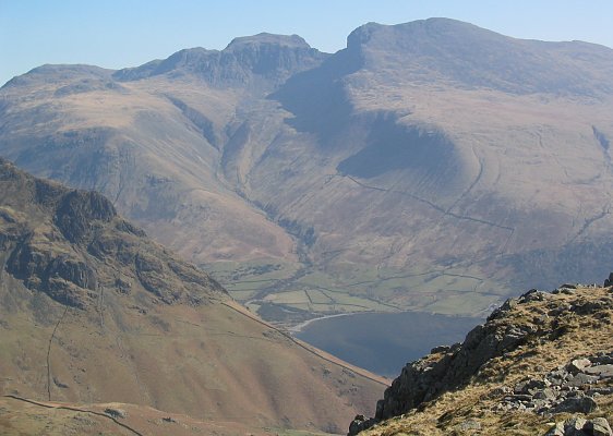
 Looking east from Middle Fell across Wastwater. Mickledore is the distinctive notch in the skyline between Scafell Pike (left) and Sca Fell (right).
Mickledore (the name means great door or pass) is a narrow ridge, 840 metres (2755 ft) high, connecting the mountains of Sca Fell and Scafell Pike in the English Lake District. It is also a pass between the valleys of Wasdale and Eskdale.
The ridge is easily reached and traversed from Scafell Pike to the north, or from the valleys to the east and west. However, access to the summit of Sca Fell is barred by the rockface of Broad Stand, which looks much easier to climb than it is (the climb is "Difficult" in the British grading system [1]). In descent, the cliff is even more dangerous. The poet Samuel Taylor Coleridge probably made a descent on 5 August 1802; he wrote:
 Looking south from Mickledore towards Broad Stand.
- I began to suspect that I ought not to go on, but then unfortunately tho' I could with ease drop down a smooth Rock 7 feet (2.1 m) high, I could not climb it, so go on I must and on I went. The next 3 drops were not half a Foot, at least not a foot more than my own height, but every Drop increased the Palsy of my Limbs — I shook all over, Heaven knows without the least influence of Fear, and now I had only two more to drop down, to return was impossible — but of these two the first was tremendous, it was twice my own height, and the Ledge at the bottom was so exceedingly narrow, that if I dropt down upon it I must of necessity have fallen backwards and of course killed myself. My Limbs were all in a tremble — I lay upon my Back to rest myself, and was beginning according to my Custom to laugh at myself for a Madman, when the sight of the Crags above me on each side, and the impetuous Clouds just over them, posting so luridly and so rapidly northward, overawed me. I lay in a state of almost prophetic Trance and Delight — and blessed God aloud, for the powers of Reason and the Will, which remaining no Danger can overpower us! [2]
The walker seeking a safe route between England's highest mountains must go via Foxes Tarn, which involves a descent to 680 m or so, about 160 m below the height of the ridge. The more challenging routes of Lord's Rake (currently threatened by loose rock following a rockfall in 2001), and the West Wall Traverse, offer alternative ways to reach Scafell Pike.
References
- ^ A. Phizacklea (1996), Scafell, Wasdale & Eskdale, Fell and Rock Climbing Club of the English Lake District.
- ^ Samuel Taylor Coleridge (1802), letter to Sara Hutchinson.
Categories:- Mountain passes of the Lake District
- Geography of Cumbria

Wikimedia Foundation. 2010.