- Przasnysz County
Infobox Settlement
name = Przasnysz County
native_name = Powiat przasnyski
settlement_type = County
total_type = Total
image_shield = POL powiat przasnyski COA.svg
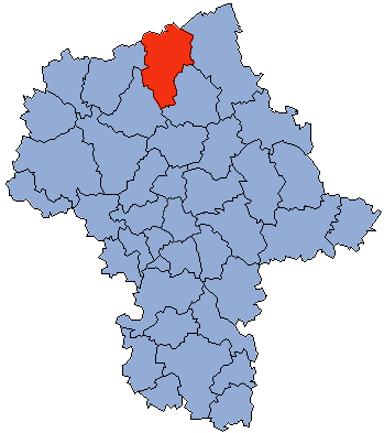
map_caption = Location within the voivodeship
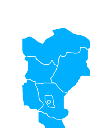
map_caption1 = Division into gminas
subdivision_type = Country
subdivision_name = POL
subdivision_type1 = Voivodeship
subdivision_name1 = Masovian
area_total_km2 = 1217.82
population_total = 52948
population_as_of = 2006
population_density_km2 = auto
population_urban = 19852
population_blank1_title = Rural
population_blank1 = 33096
coor_type = Przasnysz
latd = 53
latm = 1
lats =
latNS = N
longd = 20
longm = 53
longs =
longEW = E
seat =Przasnysz
parts_type =Gmina s
parts = Total 7 (incl. 1 urban)
p1 =Przasnysz
p2 =Gmina Chorzele
p3 =Gmina Czernice Borowe
p4 =Gmina Jednorożec
p5 = Gmina Krasne
p6 =Gmina Krzynowłoga Mała
p7 =Gmina Przasnysz
blank_name = Car plates
blank_info = WPZ
website = http://www.powiat-przasnysz.pl __NOTOC__Przasnysz County ( _pl. powiat przasnyski) is a unit of territorial administration and local government (powiat ) inMasovian Voivodeship , east-centralPoland . It was created onJanuary 1 ,1999 as a result of the Local Government Reorganization Act of 1998. Its administrative seat and largest town isPrzasnysz , which lies convert|90|km|mi|0 north ofWarsaw . The only other town in the county isChorzele , lying convert|26|km|mi|0|abbr=on north of Przasnysz.The county covers an area of convert|1217.82|km2|sqmi|1. As of 2006 its total population is 52,948, out of which the population of Przasnysz is 17,069, that of Chorzele is 2,783, and the rural population is 33,096.
Neighbouring counties
Przasnysz County is bordered by
Szczytno County to the north,Ostrołęka County to the east,Maków County to the south-east,Ciechanów County to the south-west,Mława County to the west andNidzica County to the north-west.Administrative division
The county is subdivided into seven
gmina s (one urban, one urban-rural and five rural). These are listed in the following table, in descending order of population.References
* [http://www.stat.gov.pl/gus/45_655_PLK_HTML.htm Polish official population figures 2006]

Wikimedia Foundation. 2010.