- Dukinfield
-
For other uses, see Dukinfield (disambiguation).
Coordinates: 53°28′26″N 2°04′58″W / 53.4739°N 2.0828°W
Dukinfield 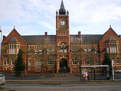
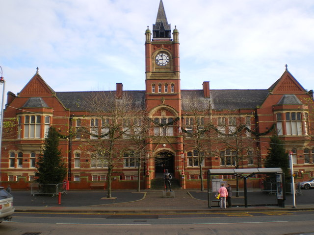
Dukinfield Town Hall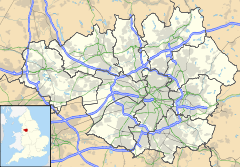
 Dukinfield
Dukinfield shown within Greater ManchesterPopulation 18,885 (2001 Census) OS grid reference SJ945975 - London 160 mi (257 km) SSE Metropolitan borough Tameside Metropolitan county Greater Manchester Region North West Country England Sovereign state United Kingdom Post town DUKINFIELD Postcode district SK16 Dialling code 0161 Police Greater Manchester Fire Greater Manchester Ambulance North West EU Parliament North West England UK Parliament Denton and Reddish List of places: UK • England • Greater Manchester Dukinfield is a small town within the Metropolitan Borough of Tameside, in Greater Manchester, England.[1][2] It lies in central Tameside on the south bank of the River Tame, opposite Ashton-under-Lyne, and is 6.3 miles (10.1 km) east of the city of Manchester. At the time of the 2001 census it had a population of 18,885.[3]
Historically a part of Cheshire, the town is a product of the Industrial Revolution when its development was accelerated by the growth of coal mining and the cotton industry.
Contents
History
Early history
The earliest evidence of human activity around Dukinfield comes from a collection of four flints from the late Neolithic/early Bronze Age. The artefacts were discovered on the site of Dukinfield Hall and have been taken as evidence of a prehistoric settlement on the site.[4] There is no further evidence of activity in the area until the Roman period. A 3rd-century bronze Roman coin, from the reign of Emperor Tetricus I was discovered in the town.[5]
Dukinfield means "open land of the ducks" and derives from the Old English duce and feld.[6]
Early records show the township was included in the fee of Dunham Massey. It was held by Matthew de Bramhall in about 1190 and after that by a family who took the name "De Dokenfeld". The family lived at the moated Dukinfield Old Hall which originated from after the Conquest and was rebuilt in Tudor times remaining the home of the Dukinfields till the18th century after which it became derelict.[7] During the English Civil War, Colonel Robert Duckenfield[8] of Dukinfield Hall was a noted commander in the New Model Army.[9] The Baronetcy, Dukinfield of Dukinfield, Cheshire was created in 1665 for Robert Dukinfield, son of Colonel Robert Dukinfield. The Dukinfields held the manor for five centuries until the widow of Sir William Dukinfield Daniel married the artist, John Astley, in 1767. In 1848 his descendant, colliery owner Francis Dukinfield P. Astley, was the lord of the manor. Dukinfield Lodge was built by the Astleys on a hill overlooking the River Tame.[7]
Industrial Revolution
Industrialisation - particularly the cotton trade - helped shape the town, but its rapid development destroyed its former pasture and meadow land. Two cotton mills were built before 1794 and by 1825 there were seven.[7] The industry continued to expand and by the end of the 19th century 14 spinning mills of varying sizes were in operation. The largest mills were built in brick during the 1890s with four or five storeys, large windows, ornamental towers, engine houses and tall brick built chimneys. They included Tower, Tame Valley, River, Park Road and Queen Mills.[10] Most of the cotton mills have now been demolished, but some have been preserved and converted into apartments.
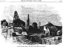 Dukinfield Colliery
Coal pits exploiting the underlying coal measures to the south of the Lancashire Coalfield were a major part of Dukinfield's industrial history, one pithead was located on Birch Lane, now the site of All Saints' Catholic College, with another near the northern border with Ashton-under-Lyne. Francis Dukinfield Astley developed two collieries in the town, Dukinfield and Astley Deep Pit, and both had explosions killing many workers. Dukinfield Colliery (also known as Lakes Pit or Victoria Colliery) was owned by Astley's Dukinfield Colliery Company. The colliery had two shafts, the downcast was 340 yards deep to the Black mine (coal seam) and was connected to the upcast ventilation shaft. On 4 June 1867, 38 men and boys died of suffocation following an explosion caused by a faulty safety lamp and poor management.[11]
Astley Deep Pit, was off King's Street opposite Brownlea Avenue was developed by Astley but by 1874 was owned by Benjamin Ashton. The colliery's downcast shaft was 686 yards deep and its workings extended over a mile to the south and about 1,300 yards to the north of the shaft. [12] This colliery was reported to be at one time, the deepest coal mine in the world, at 2100 feet (640 metres) and had three shafts.[13] On 14 April 1874 an underground gas explosion killed 54 men.[14] After the pit closed in 1901 the shafts were filled in and left to stand for many years before being built on. It is now the site of a development of houses comprising Angel Close, Oval Drive and Silver Close.
Samuel Robinson a Unitarian, industrialist and scholar founded the village library in 1833 and was dubbed the "foremost promoter of education in the district" before his death in 1884. Daniel Adamson a mechanical engineer became the first chairman of the Manchester Ship Canal Company. He owned an engineering works producing Lancashire boilers at Newton Wood beside the Manchester, Sheffield and Lincolnshire Railway.[10] He died on 13 January 1890. The Adamson Military Band, named after Adamson is based in Dukinfield.[15]
Dukinfield and its surrounding towns were major centres of civil revolt during the 19th century and briefly the area was a hotbed of Chartism, the popular movement calling for universal suffrage via a "People's Charter". Chartist leader, Reverend Joseph Rayner Stephens is buried in St John's Church cemetery.
Governance
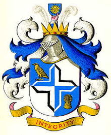 Coat of arms of the former Dukinfield Municipal Borough Council
In the Middle Ages, Dukinfield was part of the parish of Stockport in the Macclesfield Hundred. It became a civil parish in 1866 and in 1894 those parts not already included in the Municipal Borough of Stalybridge became an urban district in the administrative county of Cheshire.[16] The town was granted municipal borough status in 1899 under the provisions of the Municipal Corporations Act 1882, and was expanded in 1936, gaining part of the civil parish of Matley, which had been abolished.
In 1974, the Municipal Borough of Dukinfield was abolished, and its territory amalgamated into the newly created Metropolitan Borough of Tameside, in the metropolitan county of Greater Manchester.[17]
Dukinfield is currently represented by the occupants of 6 of the 57 seats on Tameside Metropolitan Borough Council. These seats are spread over two wards: Dukinfield and Dukinfield Stalybridge. Dukinfield currently has five Labour councillors and one Conservative councillor.
Andrew Gwynne is Dukinfield's Member of Parliament. He was elected in 2005 to represent the Denton and Reddish constituency, of which the town of Dukinfield is a part. Between 1918 and 1997 Dukinfield was part of the Stalybridge and Hyde constituency.
Geography and geology
Neighbouring towns, villages and places. 
Ashton-under-Lyne Ashton-under-Lyne Hurst Audenshaw 
Stalybridge  Dukinfield

Denton Hyde Matley At 53°28′40.14″N 02°05′33.3″W / 53.4778167°N 2.092583°W (53.477818° -2.092584°), and 159 miles (256 km) north-northwest of London, Dukinfield's borders are defined to the north and west by the River Tame.
The town is situated at the edge of the Cheshire Plain where it meets the Pennines, and Dukinfield is the first town on the hill. The park is situated approximately a quarter of a mile from the Town Hall along King Street towards Hyde in the South. Because of the quite steep rise out of the plain, the park is terraced and is over 90 feet higher at the top. The hill flattens out slightly before rising steeply again towards the East, where the library is situated. The Town Hall is also at the base of the same hill with Astley Street rising steeply along its shorter Southern side before climbing some 120 feet to the crest of the ridge. The local soil is mainly clayey with some alluvial deposits.[18]
The underlying geology is the middle coal measures, which run north–south under Tameside. Dukinfield is situated on the site of a vast ancient lake or swamp that covered the area. This ancient lake is the reason coal is found in the area. The layers of shale and coal are laid on top of each other in bands, only 20 or 30 feet thick. The coal deposits fall away at a 20 degree or so angle, and runs eight or nine miles from the base of the hill out under the plain. The coal deposits are known as the Dukinfield Marine Band and form a V shape running out from here towards Stockport in the south and Ashton Moss in the north east. Dukinfield had several mines of which Astley Deep Pit had the best coal. There are many seams or mines of coal found here. Dukinfield coal was known to be the best for heating and steam generation. Only a mile to the south along Hyde Road is another large mine, the Dewsnap Colliery, which was of a lower quality and so was not in as much demand. The Dukinfield Marine Band outcrops at Dukinfield, and continues up the hill towards the top of the ridge, some 140 feet above the level of the plain where it flattens out and a third mine was situated.
Demography
Further information: Demography of Greater ManchesterDukinfield compared 2001 UK census Dukinfield[19] Tameside[20] England Total population 18,885 213,043 49,138,831 White 97.3% 94.6% 90.9% Asian 1.7% 4.0% 4.6% Black 0.1% 0.3% 2.3% According to the Office for National Statistics, at the time of the United Kingdom Census 2001, Dukinfield had a population of 18,885. The 2001 population density was 9,922 inhabitants per square mile (3,831 /km2), with a 100 to 93.9 female-to-male ratio.[21] Of those over 16 years old, 29.1% were single (never married), 42.1% married, and 9.4% divorced.[22] Dukinfield's 8,072 households included 31.2% one-person, 36.8% married couples living together, 9.9% were co-habiting couples, and 10.5% single parents with their children.[23] Of those aged 16–74, 35.1% had no academic qualifications.[24]
As of the 2001 UK census, 79.0% of Dukinfield's residents reported themselves as Christian, 0.9% Hindu, 0.8% Muslim, and 0.1% Buddhist. The census recorded 12.2% as having no religion, 0.1% had an alternative religion and 6.8% did not state their religion.[25]
Population change
Population growth in Dukinfield since 1801 Year 1801 1811 1821 1831 1841 1851 1861 1871 1881 1891 1901 1911 1921 1931 1939 1951 1961 1971 2001 Population 1,737 3,053 5,096 14,681 22,394 26,418 15,024 14,085 16,942 17,385 18,929 19,422 19,509 19,311 17,749 18,451 17,316 17,302 17,917 Source: A Vision of Britain through Time[26] Dukinfield grew from a small village just south of Ashton-under-Lyne with open land to the south and east, the gap between it and the surrounding towns of Hyde and Matley being a semicircle around 1.5 miles wide, to fill the gap entirely by the late 1940s. In its early days from 1801, and previously, the population was small but boomed during the days of the cotton industry and later the coal industry with its major rail junction adding to its prosperity and growth.
The industries which sustained it died out by the turn of the 1900s, leaving only the Daniel Adamson Ltd works but it managed to maintain its population and has only declined by 2000 since 1921. One reason is that it has a central location on the main road from Stockport to Ashton-under-Lyne and is within easy commuting distance of Manchester.
Economy
Dukinfield compared 2001 UK Census Dukinfield[27] Tameside[28] England Population of working age 13,621 151,445 35,532,091 Full time employment 45.6% 43.5% 40.8% Part time employment 11.8% 11.9% 11.8% Self employed 5.9% 6.5% 8.3% Unemployed 3.2% 3.3% 3.3% Retired 13.1% 13.3% 13.5% According to the 2001 UK census, the industry of employment of residents of Dukinfield aged 16–74 was 24.4% manufacturing, 19.3% retail and wholesale, 10.0% health and social work, 9.5% property and business services, 7.2% construction, 6.5% transport and communications, 5.7% education, 4.7% public administration, 4.4% finance, 3.4% hotels and restaurants, 1.0% energy and water supply, 0.3% agriculture, 0.1% mining, and 3.6% other.[29] Compared with national figures, the town had a relatively high proportion of people working in manufacturing, and low levels of people working in agriculture, public administration, and education.[30] The census recorded the economic activity of residents aged 16–74, 2.1% students were with jobs, 2.8% students without jobs, 4.9% looking after home or family, 7.9% permanently sick or disabled, and 2.7% economically inactive for other reasons.[27]
Landmarks
Dukinfield town hall was built in the late 1890s and opened in 1901. It was built by raising funds from the inception of the Borough of Dukinfield. The park was also made and cost the same amount of money as the town hall. There is an 80 ft difference between the King Street lower side and the rear of the park, being the first hill off the Cheshire plain, and on a clear day it is possible to stand at the top of the steps and see Manchester city centre.
Old Hall Chapel is an old historic church, claiming to be the first independent church in the 17th century. It was built during the late 15th century but is unfortunately partially derelict due to fire in the 1970s which destroyed much of the superstructure of the roof.
Transport
Public transport in the area is co-ordinated by the Greater Manchester Passenger Transport Executive. There are many bus routes through the town. Services from north to south terminate in Ashton-under-Lyne to the north and Stockport in the south, as well as east to west terminating in Glossop to the east and Manchester in the west. National coaches stop here offering connection to the rest of Britain.
There have been proposals to build a railway station near the site of the Astley Deep pit alongside the Dewsnap sidings, but as yet these have not been put into action.
The nearest airports are Manchester to the south west and Leeds Bradford to the east.
There are several canals which cross through the town and outlying areas giving connection to Marple and Manchester and cross the Pennines to West Yorkshire and beyond.
Education
There are numerous primary schools and nurseries in the town for 5-11 year olds.[14]
There are secondary schools but no dedicated facility in Dukinfield for further education, the nearest establishment being Tameside College in Ashton-under-Lyne or Hyde. All Saints Catholic College on Birch Lane / Kenyon Avenue provides education for 16-18 year olds. Since 1998, the sixth form facility has been provided for in a purpose-built extension to the main school.
Religion
The parish church dedicated to St. John the Evangelist is a Commissioners' church built between 1840 and 1841 and consecrated the following year. A second parish was formed in 1846 and its church dedicated to St Mark was begun in 1847.
A number of Protestant and Catholic churches are based in the municipality, with the nearest mosque being in Ashton-under-Lyne, a short distance to the north of the town.
Sports
Dukinfield Cricket Club, founded in 1870, is a member of the Lancashire County League. For several seasons Paul Turner was the clubs "professional" player, leaving at the end of the 2005 season. He was replaced in 2006 by Andrew Gleave from Flowery Field Cricket Club, where he had been a leading amateur. Martin Vidler is the club's youth coach.
Dukinfield Rugby Union Football Club currently plays in the South Lancashire & Cheshire 2 League of the Northern Division. The club plays its home games at Blocksages Playing Fields and is one of the oldest Rugby teams from the historic county of Cheshire, having been founded in 1880. During the late 90's and early 00's, Mike Ford was head coach gaining 2 league promotions in 3 seasons. He left Dukinfield RUFC for a brief spell at Oldham RUFC but then left to take over as Defensive coordinator of Ireland (January 2002 - September 2005). In September 2004 he started working as Defence and Skills coach at Saracens in the Guinness Premiership before taking over as Head Coach. He is now the defence coach of the England national rugby union team.
Dukinfield Town AFC, founded in 1948, plays in the Bridgewater Office Supplies Manchester League and has a ground at Blocksage's Playing Fields, Birch Lane, next to Dukinfield Rugby Club.
Public services
Dukinfield's town hall provides some limited civic facilities, including a police station, with the majority of local administration being based at Tameside Council headquarters, in Ashton-under-Lyne.
Dukinfield has a public library which is situated in Concord Way, as part of a small shopping precinct. Morrisons have a supermarket in the town. The old library was situated on Town Lane on land donated by the Astley family who donated money towards the building. There is a well-proportioned park, around a quarter-mile from the town hall, providing gardens, a play area and leisure facilities.
A public swimming pool and sauna is available as part of the borough facilities offered by Tameside Sport, as well as two full-size sports pitches, these are currently used by the town's rugby and football teams. Astley Community Sports College provides artificial multi-sports pitches, which can be reserved for use by the general public, outside school hours.
Notable people
Sportsmen
- First-class cricketer Norman 'Buddy' Oldfield was born in Dukinfield. He played first class cricket for Lancashire and Northamptonshire from 1935 to 1954 and England in 1939.[31]
- Tony Brooks 1950s Formula One driver with 5 Grand Prix victories.
- Tony Durose was born in Dukinfield and played first-class cricket for Northamptonshire in 1964–1969.[32]
Actors and actresses
- Kathy Staff, born 12 July 1928, died 13 December 2008
- Shirley Stelfox, born 11 April 1941.
- John Normington, born 28 January 1937.
Musicians
- John Lever, drummer with The Chameleons, The Sun & The Moon, later Stamford Cars.
- Ronnie Hazlehurst, celebrated composer & arranger of TV & radio theme music.
- Kevin Parrott, record producer, musician. Producer of "Matchstalk Men and Matchstalk Cats and Dogs" by Brian and Michael, and the "Brian" of the said act.
Politicians
- Carole James, Canadian politician and former Leader of the Opposition in the Legislative Assembly of British Columbia
See also
References
- Notes
- ^ "Greater Manchester Gazetteer". Greater Manchester County Record Office. Places names - D to F. http://www.gmcro.co.uk/Guides/Gazeteer/gazzd.htm. Retrieved 20 June 2007.
- ^ HMSO. Local Government Act 1972. 1972 c.70.
- ^ "KS01 Usual resident population: Census 2001, Key Statistics for urban areas". National Statistics. http://www.statistics.gov.uk/StatBase/ssdataset.asp?vlnk=8271&Pos=2&ColRank=1&Rank=224. Retrieved 2008-12-07.
- ^ Nevell (1992), pp. 37–38.
- ^ Nevell (1992), p. 69.
- ^ Dodgson (1970a), p. 276.
- ^ a b c Lewis, Samuel (1848), "Dukinfield", A Topographical Dictionary of England (British History Online): pp. 96–102, http://www.british-history.ac.uk/report.aspx?compid=50929#s13, retrieved 2011-02-24
- ^ "Colonel Dukinfield Civil war commander". [1]. 1964-06-23. http://duckenfield.org/uk/articles/colonal%20robert.htm.
- ^ "Blue Plaque - Robert Dukenfield". [2]. 2007-09-12. http://www.tameside.gov.uk/blueplaque/robertduckenfield.
- ^ a b Ashmore (1982), p. 92.
- ^ (PDF) Dukinfield Colliery, cmhrc.co.uk, p. 5, http://www.cmhrc.co.uk/cms/document/1867_69.pdf, retrieved 2011-02-24
- ^ (PDF) Astley Deep Pit, cmhrc.co.uk, p. 10, http://www.cmhrc.co.uk/cms/document/1873_75.pdf, retrieved 2011-02-24
- ^ "Dukinfield Facts and Figures". [3]. 2008-08-02. http://www.tameside.gov.uk/dukinfield/facts.
- ^ a b "Blue Plaque - The Astley Deep pit disaster". [4]. 2007-09-12. http://www.tameside.gov.uk/blueplaque/astleypit.
- ^ "Adamsons band history". [5]. 2009-01-01. http://www.adamsonband.co.uk/History.htm.
- ^ A Vision of Britain Through Time : Dukinfield Municipal Borough
- ^ Tameside.gov.uk
- ^ Nevell (1992), pp. 8, 10.
- ^ "KS06 Ethnic group: Census 2001, Key Statistics for urban areas". Statistics.gov.uk. 25 January 2005. http://www.statistics.gov.uk/statbase/ssdataset.asp?vlnk=8283&More=Y. Retrieved 15 April 2009.
- ^ "Tameside Metropolitan Borough ethnic group". Statistics.gov.uk. http://neighbourhood.statistics.gov.uk/dissemination/LeadTableView.do?a=7&b=276783&c=Tameside&d=13&e=16&g=355472&i=1001x1003x1004&o=1&m=0&r=1&s=1239833478156&enc=1&dsFamilyId=87. Retrieved 15 April 2009.
- ^ "KS01 Usual resident population: Census 2001, Key Statistics for urban areas". Statistics.gov.uk. 7 February 2005. http://www.statistics.gov.uk/statbase/ssdataset.asp?vlnk=8271&More=Y. Retrieved 15 April 2009.
- ^ "KS04 Marital status: Census 2001, Key Statistics for urban areas". Statistics.gov.uk. 2 February 2005. http://www.statistics.gov.uk/statbase/ssdataset.asp?vlnk=8276&More=Y. Retrieved 15 April 2009.
- ^ "KS20 Household composition: Census 2001, Key Statistics for urban areas". Statistics.gov.uk. 2 February 2005. http://www.statistics.gov.uk/statbase/ssdataset.asp?vlnk=8349&More=Y. Retrieved 15 April 2009.
- ^ "KS13 Qualifications and students: Census 2001, Key Statistics for urban areas". Statistics.gov.uk. 2 February 2005. http://www.statistics.gov.uk/statbase/ssdataset.asp?vlnk=8326&More=Y. Retrieved 15 April 2009.
- ^ "KS07 Religion: Census 2001, Key Statistics for urban areas". Statistics.gov.uk. 2 February 2005. http://www.statistics.gov.uk/statbase/ssdataset.asp?vlnk=8286&More=Y. Retrieved 15 April 2009.
- ^ Nevell (1993), p. 12.
- ^ a b "KS09a Economic activity - all people: Census 2001, Key Statistics for urban areas". Statistics.gov.uk. 3 February 2005. http://www.statistics.gov.uk/statbase/ssdataset.asp?vlnk=8292&More=Y. Retrieved 17 April 2009.
- ^ "Tameside Local Authority economic activity". Statistics.gov.uk. http://neighbourhood.statistics.gov.uk/dissemination/LeadTableView.do?a=7&b=276783&c=Tameside&d=13&e=16&g=355472&i=1001x1003x1004&o=1&m=0&r=1&s=1239987722586&enc=1&dsFamilyId=107. Retrieved 17 April 2009.
- ^ "KS11a Industry of employment - all people: Census 2001, Key Statistics for urban areas". Statistics.gov.uk. 3 February 2005. http://www.statistics.gov.uk/statbase/ssdataset.asp?vlnk=8306&More=Y. Retrieved 17 April 2009.
- ^ "Tameside Local Authority industry of employment". Statistics.gov.uk. http://neighbourhood.statistics.gov.uk/dissemination/LeadTableView.do?a=7&b=276783&c=Tameside&d=13&e=16&g=355472&i=1001x1003x1004&o=1&m=0&r=1&s=1239989636886&enc=1&dsFamilyId=119. Retrieved 17 April 2009.
- ^ Wisden Cricketers' Almanack. "Buddy Oldfield player profile". Cricinfo.com. http://content-www.cricinfo.com/england/content/player/18255.html. Retrieved 2007-08-28.
- ^ "Antony Durose player profile". Cricinfo.com. http://content-uk.cricinfo.com/england/content/player/12280.html. Retrieved 20 February 2009.
- Bibliography
- Ashmore, Owen (1982). The Industrial archaeology of North-west England. Manchester University Press. ISBN 0 7190 0820 4.
- Dodgson, J. McN. (1970a). The place-names of Cheshire. Part one: County name, regional- & forest names, river-names, road-names, the place-names of Macclesfield Hundred. Cambridge: Cambridge University Press. ISBN 0-521-07703-6.
- Hickey, JE (1924). Dukinfield Past and Present. Whittacker & Sons.
- Nevell, Mike (1992). Tameside Before 1066. Tameside Metropolitan Borough and Greater Manchester Archaeological Unit. ISBN 1-871324-07-6.
- Nevell, Mike (1993). Tameside 1700–1930. Tameside Metropolitan Borough and University of Manchester Archaeological Unit. ISBN 1-871324-08-4.
- Pavasovic, Mike (1984). No Mean City – A History of Dukinfield. Neil Richardson. ISBN 0-907511-60-0.
Categories:- Geography of Tameside
- Towns in Greater Manchester


Wikimedia Foundation. 2010.