- CityLink
-
For other uses of "City Link", see City Link (disambiguation).
CityLink Route information Maintained by Transurban Limited Length: 22 km (14 mi) Existed: May 1996 – present History: Completed August 1999 Major junctions From: Tullamarine Freeway West Gate Freeway
Tullamarine Freeway
Calder Freeway
Monash FreewayTo: Monash Freeway Location Primary
destinations:Melbourne Airport
Melbourne CBD
Northern suburbs
Eastern suburbsHighway system Highways in Australia
National Highway • Freeways in Australia
Highways in VictoriaCityLink is a system of tolled urban Highways in Melbourne, Victoria, Australia. The company Transurban was awarded the contract to augment two existing freeways and construct two new Toll roads—labelled the Western and Southern Links—directly linking a number of existing freeways to provide a continuous, high-capacity road route to, and around, the central business district.
Contents
History
The first mention of a Southern and Western inner city bypass was in the 1969 Melbourne Transportation Plan. The plan advocated for reservations and set aside sinking funds for the new inner city freeway system. It was one of the few freeways connecting to the inner city (along with the Eastern Freeway to Clifton Hill) which was not later canned.
The proposal to build CityLink was first announced in May 1992 and received the State Government's formal approval in mid-1994. The contract was awarded to Transurban, a partnership between Australia's Transfield Services and Japan's Obayashi Corporation in 1995.[1] The total value of the project was estimated in 1996 at about $1.8 billion, and the 34 year concession to operate the road expires in 2035.[2]
CityLink was built between 1996 and 2000 and was eight times larger any other road project in Melbourne to that time. Toll plazas for manual tolling were impractical, and delays associated with plaza operations would have decreased the advantages of using the new road. The decision to use only electronic toll collection was made in 1992, when there was no real field experience in the field.[3] The first of the sections opened to traffic in August 1999, with tolling commencing on 3 January 2000 before final completion occurred on 28 December 2000 with tolling commencing the same year.[4]
The Exhibition Street Extension was not part of the initial project, as the project had been promoted as a bypass that would keep cars out of the CBD.[5] Under a contract announced in April 1998, Transurban would operate the road and collect tolls from road users,[4] with the road being opened in October 1999.[6]
Existing freeways
Previously, the city centre was served by four separate freeways:
- The
 Monash Freeway (also previously known as the South Eastern Freeway, South Eastern Arterial, and Mulgrave Freeway in different sections of the existing route) which had begun approximately 2 km south-east of the city, and connects Melbourne to the outlying rural Gippsland area;
 - The /
 /
/ Tullamarine Freeway which had begun approximately 5 km north-west of the city, and links Melbourne to Tullamarine Airport, and also joins the
  Calder Freeway, which links Melbourne to Bendigo;
 - The West Gate Freeway (also previously known as the Lower Yarra Freeway) which had begun near Port Melbourne, just southwest of the city, crossing the Yarra River using the West Gate Bridge and joins to both the Princes Freeway (linking to Geelong) and the
 Western Ring Road;
 - The
 Eastern Freeway which begins near Collingwood, passing through Melbourne's eastern and north-eastern suburbs.
CityLink saw the widening and upgrading of the inner sections of the Tullamarine and Monash Freeways, as well tolls being imposed, which attracted criticism from road users.
New freeways
Western Link
 The sound tube in Flemington used to reduce noise pollution to nearby community housing towers
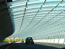
 Interchange consisting of the Burnley Tunnel entrance, Domain Tunnel entrance, Westgate freeway and Power Street/Kings Way ramps.
The elevated Western Link extends the existing Tullamarine Freeway, lengthening it to terminate it five kilometres further south at the West Gate Freeway in Port Melbourne. It includes a new major bridge (the Bolte Bridge, named after former Premier Sir Henry Bolte) over the Yarra River in the Docklands; and a tube-like sound barrier in Flemington where the road passes close to a number of community housing towers. A short distance to the north of the sound tube, a massive sculptural work was placed, called the Melbourne International Gateway, consisting of a giant yellow beam hanging diagonally across the road (nicknamed the "Cheesestick") and a row of smaller red beams alongside the road (the "Zipper", or "rack of lamb"). The Tullamarine Freeway was also widended from Bell Street to Flemington Road, with a transit lane being added in each direction.
This section of Freeway was originally designated in the 1969 Melbourne Transportation Plan as part of the F14 Freeway Corridor.
Southern Link
The underground Southern Link directly connects the ends of the West Gate and Monash Freeways into one continuous through-way. This link comprises the Burnley and Domain Tunnels which pass under the Royal Botanic Gardens and the Yarra River, each tunnel channelling traffic in different directions. This link also includes a connection to the CBD from the Monash Freeway over a bridge extension of Exhibition Street over the nearby railway lines.
This section of Freeway was shown in the 1969 Melbourne Transportation Plan as part of the F9 Freeway corridor as a surface-level road.
Tolling system
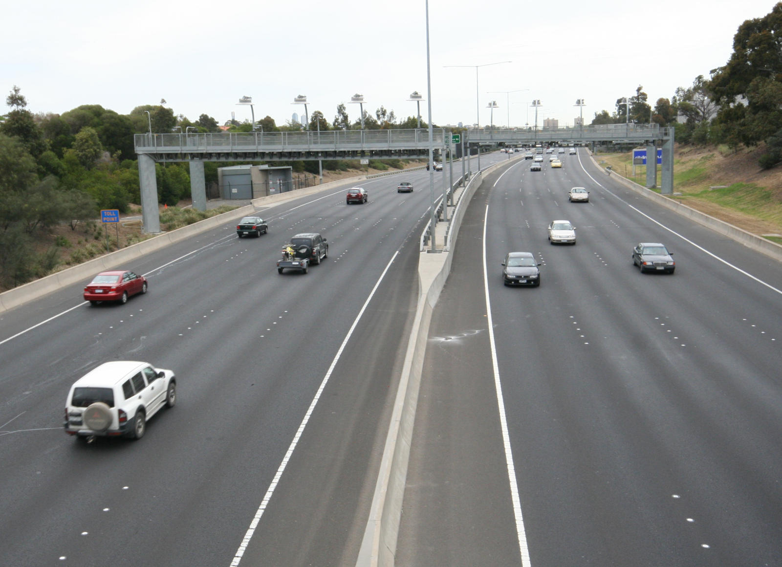
Main article: e-TAG e-TAG toll gantries on the Tullamarine Freeway section of Melbourne's CityLink
There are no toll booths along the entire length of the system, so traffic flow is not impeded.
CityLink uses a DSRC toll system called e-TAG, where an electronic transponder is mounted on the inside of the vehicles' windscreen. Gantries constructed over each carriageway record registration plates and detect the e-TAGs, and deduct toll amounts automatically from the account linked electronically to each tag. Where a tag is not detected, the vehicle's registration is recorded using an automatic number plate recognition system and checked against a database. For infrequent use of the system one can buy a Daypass – by phone, online, at any Australia Post outlet or at participating service stations. A Daypass can be bought in advance or afterwards (until midnight three days later). The vehicle's registered owner will be sent a late toll invoice fine in the mail if payment is not made, and if the late toll invoice is then not paid a fine will be issued by civic compliance victoria.
The system came under fire in 2003 when it was found that e-TAGs did not warn drivers when their batteries were running low, and non-functioning batteries caused vehicles not to be detected by the toll sensors, thereby attracting additional charges and fines.[7] CityLink has since recognised that e-TAGs have a limited lifespan and have undertaken a campaign to raise awareness among customers to contact them should their e-TAG not beep.[8]
Controversies
- As part of the development of CityLink, existing roads were upgraded and expanded, and tolling points were added. Toll charges now apply to the Monash Freeway (between Toorak Road and Punt Road) and the Tullamarine Freeway (south of Bulla Road). These roads did not cost tolls to use before.[9]
- Some nearby roads were altered to restrict rat runs to stop people using neighbourhood back streets as short cuts to avoid the toll.[10] Some people have viewed this as local councils 'forcing' people to use CityLink.[11]
- CityLink account holders can, if they make multiple trips in a day, pay more to use the road than a casual user. A 24 hour Pass, for example, is charged at a flat rate, but an account holder pays per trip. Account holders who make multiple trips in a single day may pay more than a pass customer would. However, CityLink recognises this and account customers can remove their e-TAG device and buy a pass for the day: just like casual customers. However there is a limit to the number of passes that can be bought each 12 months.[12]
- The contract between the government and CityLink's owner Transurban has protections for both parties. One of these is the ability for Transurban to make a claim against the state government if the state government does something that reduces the number of cars that could use CityLink. In 2001 Transurban commenced legal proceedings against the State of Victoria over the construction of Wurundjeri Way through the Melbourne Docklands. It was alleged that this 'free' road was competing with CityLink and causing it to earn less revenue.[13] This can potentially also be applied if the capacity of other roads or rail routes parallel to CityLink are expanded.[14][15]
- CityLink received negative media coverage when it was wrongly claimed that CityLink account holders' credit card details were stored on Transurban's public webserver and that someone had broken into the system and stolen tens of thousands of customers details. Customer details were stolen, not by an intruder via the web, but by a former employee who had had misused access to the secure IT systems.[16]
- The two CityLink tunnels have regularly featured as discussion points on talkback radio, firstly for air quality. In the early days of operation, the air quality in the tunnels appeared smoggy. CityLink worked a way around the problem by adjusting the venting system which improved quality and dispersed exhaust fumes more effectively.[17] The second issue was regarding the use of massive quantities of fresh drinking water pumped into the system to stabilise the tunnel environs. After some time, CityLink sought and obtained approval from the State Government to build a water recycling plant which meant they could rely primarily on recycled, and not drinking, water.[18]
Exits and intersections
Western Link
CityLink _/_  /
/ 
Northbound exits Distance to
Melbourne Airport
(km)Distance to
Melbourne City Centre
(km)Southbound exits End CityLink _
continues as Tullamarine Freeway _ 
to Bendigo / Sydney
13 10 Start CityLink _
from Tullamarine Freeway _ NORTH EAST RAIL LINE NORTH EAST RAIL LINE Strathmore, Broadmeadows
Pascoe Vale Road
Essendon, Thornbury
Moreland Road15 8 no exit no exit 17 6 Brunswick, Northcote
Brunswick Road
Moonee Ponds, Ascot Vale, Maribyrnong
Ormond Roadno exit 19 4 Parkville, Melbourne City Centre
Flemington Road
Northbound exits Distance to
Melbourne Airport
(km)Distance to
(km)Southbound exits To Eastern Freeway
Kensington, Parkville
Racecourse Road
18 7 UPFIELD RAIL LINE UPFIELD RAIL LINE NORTH EAST / WESTERN / PORT FAIRY RAIL LINE 21 4 Melbourne City Centre, Footscray
Dynon Road
NORTH EAST / WESTERN / PORT FAIRY RAIL LINE Footscray, Docklands
Footscray Road
23 2 Docklands, Footscray
Footscray RoadBOLTE BRIDGE 24 1 BOLTE BRIDGE Northbound exits Exit Number
Distance to Melbourne AirportSouthbound exits Start CityLink_
continues from West Gate Freeway--
(25 km)End CityLink _ 3 Docklands
Lorimer Street2 St Kilda, Frankston
Kings Way (Princes Highway)
1E Melbourne City Centre, Dandenong, Warragul
West Gate Freeway1W West Gate Bridge, Geelong
West Gate Freeway 
Note
Exits are numbered at the
interchange only.Southern Link
CityLink 
Westbound exits Exit Number Eastbound exits End CityLink (Domain Tunnel)
continues as West Gate Freeway
to Ballarat / Bendigo / Geelong-- Start CityLink (Burnley Tunnel)
from West Gate FreewayDOMAIN TUNNEL -- BURNLEY TUNNEL
No access to exit E1 and E2Melbourne City Centre
Batman AvenueE1 Start CityLink(Batman Avenue Extension)
from Batman AvenueRichmond, Clifton Hill
Punt Road
E2 no exit SANDRINGHAM / FRANKSTON / GIPPSLAND RAIL LINE -- SANDRINGHAM / FRANKSTON / GIPPSLAND RAIL LINE no exit -- Cremorne
Church StreetBurnley
Yarra BoulevardE3 Burnley
Burnley StreetCityLink (Batman Avenue Extension)
merges with CityLink (Burnley Tunnel)GLEN WAVERLEY RAIL LINE -- GLEN WAVERLEY RAIL LINE Start CityLink
from Monash FreewayE4 Burwood, Toorak
Toorak Road
End CityLink
continues as Monash Freeway
to Dandenong / WarragulSee also
References
- ^ Andrew Nette. "CityLink and Nam Theun 2: Infrastructure for private profit" (PDF). www.terraper.org. http://www.terraper.org/articles/WS%25205(1)%2520report%2520-%2520NT2.pdf. Retrieved 2008-07-17.[dead link]
- ^ Public Accounts and Estimates Committee (October 2006) (PDF). Report on private investment in public infrastructure. www.parliament.vic.gov.au. p. 63. ISBN 0 9758189 1 0. http://www.parliament.vic.gov.au/paec/inquiries/infrastructureinvestment/Report/Private%20investment%20in%20public%20infrastructure.pdf. Retrieved 2008-07-17.
- ^ M. G. Lay and K. F. Daley (Volume 9, Issue 3, July 2002). "The Melbourne City Link Project". Transport Policy. www.sciencedirect.com. http://www.sciencedirect.com/science?_ob=ArticleURL&_udi=B6VGG-45Y6G3K-1&_user=907278&_rdoc=1&_fmt=&_orig=search&_sort=d&view=c&_acct=C000047763&_version=1&_urlVersion=0&_userid=907278&md5=ca1805d44ade4f1c9cef7b0ea97d9aff. Retrieved 2008-07-17.
- ^ a b VicRoads. "Project Overview : CityLink". www.vicroads.vic.gov.au. http://www.vicroads.vic.gov.au/Home/RoadsAndProjects/RoadProjects/InnerCity/CityLink/ProjectOverview.htm. Retrieved 2008-07-17.
- ^ Public Transport Users Association. "Myth: The purpose of freeways is to bypass congested areas". www.ptua.org.au. http://www.ptua.org.au/myths/bypass.shtml. Retrieved 2008-07-17.
- ^ "Exhibition Street Extension Opening" (PDF). www.transurban.com.au. 26 October 1999. Archived from the original on 2008-07-20. http://web.archive.org/web/20080720082613/http://www.transurban.com.au/transurban_online/tu_nav_black.nsf/v/EDF0EFBB1424C643CA25707400322082/$file/20-MEDIA-ExhibitionStreetExtensionOpening-26October99.pdf. Retrieved 2008-07-17.
- ^ Hopkins, Philip (21 August 2003). "The Age - 'e-TAG woes take toll on Transurban shares'". Melbourne. http://www.theage.com.au/articles/2003/08/20/1061368351635.html?from=storyrhs. Retrieved 2007-08-12.
- ^ "CityLink - Using your e-TAG device". http://www.citylink.com.au/257.jsp. Retrieved 2007-08-12.
- ^ "ABC Radio 'The World Today' - 'Melbourne drivers object to CityLink' - Wednesday, 14 June". http://www.abc.net.au/worldtoday/stories/s140096.htm. Retrieved 2007-08-02.
- ^ "Minister of Transport media release - 'DATA SHOWS IMPROVEMENT IN CITY LINK TRAFFIC FLOW'". 21 September 2000. http://www.dpc.vic.gov.au/domino/Web_Notes/MediaRelArc02.nsf/17ed9415cb17e3d34a25682500254734/da8d0874ce7f98744a25696200099049!OpenDocument&Click=. Retrieved 2007-08-02.
- ^ "Inquiry into Managing Transport Congestion by Moonee Valley City Council" (PDF). 4 January 2006. http://www.vcec.vic.gov.au/CA256EAF001C7B21/WebObj/Submission77-MooneeValleyCityCouncil/$File/Submission%2077%20-%20Moonee%20Valley%20City%20Council.pdf. Retrieved 2007-08-12.
- ^ CityLink - Types of Passes
- ^ "Minister of Transport media release - 'TRANSURBAN CLAIM OF $35 MILLION'". 1 March 2001. http://www.dtf.vic.gov.au/domino/Web_Notes/MediaRelArc02.nsf/ebfd7a9e83f839b34a2568110023b2e3/5cbd5463c03ddc004a256a030017c1f4!OpenDocument&Click=. Retrieved 2007-08-12.
- ^ "The Age - 'Tollway buyback would save money and ease traffic'". Melbourne. 3 February 2005. http://www.theage.com.au/news/Kenneth-Davidson/Tollway-buyback-would-save-money-and-ease-traffic/2005/02/02/1107228766073.html. Retrieved 2007-08-12.
- ^ "The Age - 'Bracks' freeway folly will cost us dearly'". Melbourne. 29 April 2004. http://www.theage.com.au/articles/2004/04/28/1083103547962.html. Retrieved 2007-08-12.
- ^ Transurban - Media release issued 5 Dec 2002
- ^ CityLink - Tunnel Brochure
- ^ CityLink - Using Water Wisely Brochure
External links
Landmarks in the Melbourne City Centre Note: this includes landmarks in the Melbourne City Centre and its fringe areas, not the Greater Melbourne metropolitan area City Precincts Arts Precinct · Chinatown · Docklands · Government Precinct · Greek Precinct · Little Italy · Paris End · RMIT City · Southbank/Wharf · Sports and Entertainment Precinct · University of MelbourneShopping Block Arcade · Bourke Street · Bridge Road · Brunswick Street · Chapel Street · Collins Street · DFO South Wharf · Elizabeth Street · Flinders Lane · Docklands Harbour Town · Lt. Collins Street · Melbourne Central Shopping Centre · Myer Emporium · Melbourne GPO · Queen Victoria Market · Queen Victoria Village · Royal Arcade · Swanston Street
Entertainment Colonial Tramcar Restaurant · Crown Casino and Entertainment Complex · Luna Park · Melbourne Aquarium · City Tourist Shuttle · Melbourne Zoo · See also: Events in the Melbourne City Centre · Theatres in the Melbourne City Centre
Public Galleries Australian Centre for Contemporary Art · Australian Centre for the Moving Image · National Gallery of Victoria, inc. Ian Potter Centre · State Library of Victoria's Cowen Gallery, Dome Gallery and Murdoch Gallery · RMIT Gallery · See also: Museums in the Melbourne City Centre
Institutions General Post Office · Government House · Melbourne Observatory · Melbourne Town Hall · Old Melbourne Gaol · Old Melbourne Mint · Old Melbourne Magistrates' Court · Old Treasury Building · Parliament House · State Library of Victoria · Supreme Court of Victoria · Victoria Barracks
Structures Sports Stadia Melbourne Rectangular Stadium (AAMI Park) · Docklands Stadium (Etihad Stadium) · Flemington Racecourse · Melbourne Multi Purpose Venue (Hisense Arena) · Melbourne Cricket Ground (MCG) · Melbourne Grand Prix Circuit · Melbourne Sports and Aquatic Centre (MSAC) · National Ice Sports Centre (The Icehouse) · Olympic Park Stadium · Rod Laver Arena · Royal Melbourne Golf Club · Princes Park (Visy Park)
Parks/Spaces Albert Park and Lake · Alexandra Gardens · Birrarung Marr · Carlton Gardens · City Square · Federation Square · Fitzroy Gardens · Flagstaff Gardens · Kings Domain · Queen Victoria Gardens · Royal Botanic Gardens · Royal Park · Treasury Gardens · Yarra Park
Transport Bolte Bridge · Capital City Trail · City Circle Tram · CityLink · Flinders Street Station · Melbourne Airport · Melbourne Seaport · Southern Cross Station · Trams in Melbourne · West Gate Bridge
See also: Events in the Melbourne City Centre · Museums in the Melbourne City Centre · Theatres in the Melbourne City Centre Categories:- Landmarks in Melbourne
- Highways and freeways in Melbourne
- Toll roads in Australia
- Transport in Melbourne
- The


Wikimedia Foundation. 2010.