- Selenge River
Geobox|River
name = Selenge
native_name = _mn. Сэлэнгэ мөрөн
other_name = Selenga
category =
etymology =
nickname =

image_caption = Selenga river delta
country = Mongolia
country1 = Russia
state_type = Aimags
state =
state1 =
region =
district =
municipality_type = Major city
municipality = Sükhbaatar
municipality1 = Ulan-Ude
parent =
tributary_left =Egiin Gol
tributary_right =Orkhon River
city =
landmark =
source = Delgermörön
source_location = | source_region =
source_country =
source_elevation =
source_lat_d = |source_lat_m = |source_lat_s = |source_lat_NS =
source_long_d = |source_long_m = |source_long_s = |source_long_EW =
source1 = Ideriin gol
source1_location = |source1_region = |source1_country =
source1_elevation =
source1_lat_d = |source1_lat_m = |source1_lat_s = |source1_lat_NS =
source1_long_d = |source1_long_m = |source1_long_s = | source1_long_EW =
source_confluence = Olon golyn bilchir
source_confluence_location = Khövsgöl
source_confluence_region =
source_confluence_country = Mongolia
source_confluence_elevation =
source_confluence_lat_d = 49
source_confluence_lat_m = 15
source_confluence_lat_s = 40
source_confluence_lat_NS = N
source_confluence_long_d = 100
source_confluence_long_m = 40
source_confluence_long_s = 45
source_confluence_long_EW = E
mouth =Lake Baikal
mouth_location = | mouth_region = | mouth_country =
mouth_elevation =
mouth_lat_d = | mouth_lat_m = | mouth_lat_s = | mouth_lat_NS =
mouth_long_d = | mouth_long_m = | mouth_long_s = | mouth_long_EW =
length = 992
width =
depth =
volume =
watershed = 447000
discharge = 284
discharge_max = 601
discharge_max_note = August
discharge_min = 23
discharge_min_note = February
discharge_location = Ust-Kyakhta
free = | free_type =
map_caption =
map_background =
map_locator =
map_locator_x =
map_locator_y =
website =
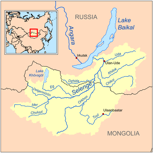
footnotes =The Selenga ( _ru. Селенга) or Selenge ( _mn. Сэлэнгэ гол, Сэлэнгэ мөрөн) is a river in
Mongolia andRussia . Its source rivers are theIderiin gol and theDelgermörön . It flows intoLake Baikal and has a length of 992 km. [H. Barthel, "Mongolei-Land zwischen Taiga und Wüste", Gotha 1990, p.34f] [cite web
url=http://www.medeelel.mn/index.php?page=land&sm=73&s=1345
title=Сэлэнгэ мөрөн
work=www.medeelel.mn
date=
accessmonthday=July 16
accessyear=2007] The Selenga is the headwater of theYenisei -Angara River.References
Wikimedia Foundation. 2010.