- Mount Nyiragongo
-
Mount Nyiragongo 
Elevation 3,470 m (11,385 ft) Location Democratic Republic of the Congo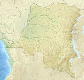
 Mount Nyiragongo
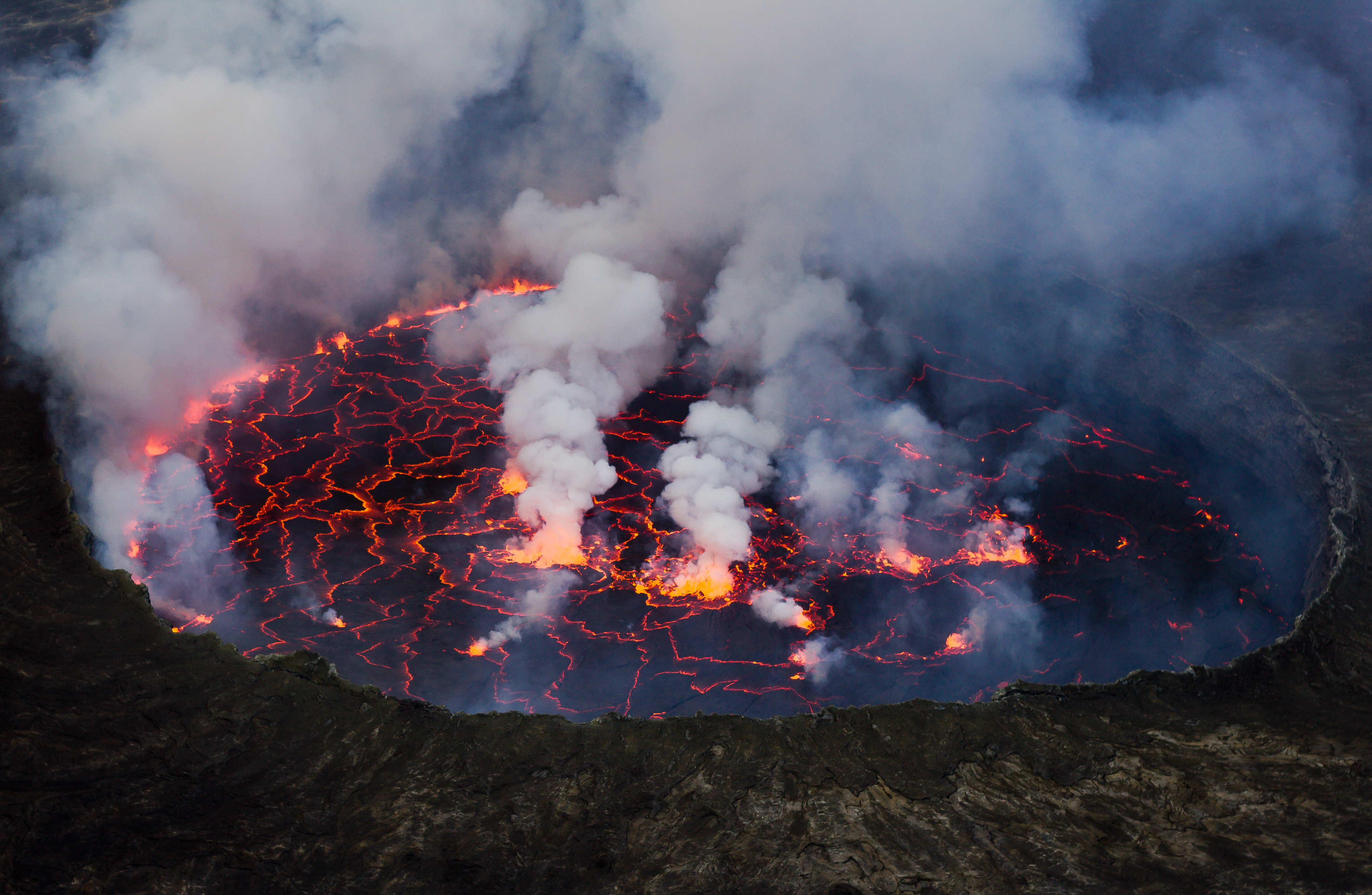
Range Virunga Mountains Coordinates 1°31′00.56″S 29°15′00.21″E / 1.5168222°S 29.2500583°ECoordinates: 1°31′00.56″S 29°15′00.21″E / 1.5168222°S 29.2500583°E Geology Type Stratovolcano Last eruption 2011 (continuing) Mount Nyiragongo is a stratovolcano[1] in the Virunga Mountains associated with the Great Rift Valley. It is located inside Virunga National Park, in the Democratic Republic of the Congo, about 20 km north of the town of Goma and Lake Kivu and just west of the border with Rwanda. The main crater is about two km wide and usually contains a lava lake. The crater presently has two distinct cooled lava benches within the crater walls - one at about 3175m (10,400 ft) and a lower one at about 2975 m (9800 ft). Nyiragongo's lava lake has at times been the most voluminous known lava lake in recent history. The depth of the lava lake varies considerably. A maximum elevation of the lava lake was recorded at about 3250 m (10,700 ft) prior to the January 1977 eruption - a lake depth of about 600 m (2000 ft). A recent very low elevation of the lava lake was recorded at about 2700 m (8800 ft). Nyiragongo and nearby Nyamuragira are together responsible for 40% of Africa's historical volcanic eruptions.
Contents
Geology
Not much is known about how long the volcano has been erupting, but since 1882, it has erupted at least 34 times, including many periods where activity was continuous for years at a time, often in the form of a churning lava lake in the crater. The volcano partly overlaps with two older volcanoes, Baratu and Shaheru, and is also surrounded by hundreds of small volcanic cinder cones from flank eruptions.
Volcanism at Nyiragongo is caused by the rifting of the Earth's crust where two parts of the African Plate are breaking apart. A hot spot is probably also partly responsible for the great activity at Nyiragongo and Nyamuragira.
 Nyamuragira (left) and Nyiragongo (right). Vertical scale exaggerated (1.5x).
The lava emitted in eruptions at Nyiragongo is often unusually fluid. Nyiragongo's lavas are made of melilite nephelinite, an alkali-rich type of volcanic rock whose unusual chemical composition may be a factor in the unusual fluidity of the lavas there. Whereas most lava flows move rather slowly and rarely pose a danger to human life, Nyiragongo's lava flows may race downhill at up to 60 miles per hour (up to 100 km/h). This is because of the extremely low silica content (the lava is mafic). Hawaiian volcanic eruptions are also characterised by lavas with low silica content, but the Hawaiian volcanoes are broad, shallow-sloped shield volcanoes in contrast to the steep-sided cone of Nyiragongo, and the silica content is high enough to slow most Hawaiian flows to walking pace.
The lava lake activity continued through 2010.[1]
1977 eruption
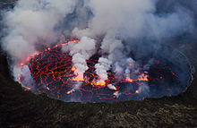 Nyiragongo's lava lake
Between 1894 and 1977 the crater contained an active lava lake. On 10 January 1977, the crater walls fractured, and the lava lake drained in less than an hour. The lava flowed down the flanks of the volcano at speeds of up to 60 miles per hour on the upper slopes, overwhelming villages and killing at least 70 people. Some reports quote much higher figures of up to several thousand people. The hazards posed by eruptions like this are unique to Nyiragongo. Nowhere else in the world does such a steep-sided stratovolcano contain a lake of such fluid lava. Nyiragongo's proximity to heavily populated areas increases its potential for causing a natural disaster. The 1977 eruption raised awareness of the unique dangers posed by Nyiragongo, and because of this it was designated a Decade Volcano, worthy of particular study, in 1991.
The 1977 eruption was preceded by the creation of a new small volcano, Murara, a short distance away on the slopes of Mount Nyamuragira.
2002 eruption
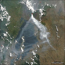 Satellite image of the eruption plume from Nyiragongo in July 2004
Lava lakes reformed in the crater in eruptions in 1982–1983 and 1994. Another major eruption of the volcano began on January 17, 2002, after several months of increased seismic and fumarolic activity. A 13 km fissure opened in the south flank of the volcano, spreading in a few hours from 2800 m to 1550 m elevation, reaching the outskirts of the city of Goma the provincial capital on the northern shore of Lake Kivu. Lava streamed from three spatter cones at the end of the fissure and flowed in a stream 200 to 1000 m wide and up to 2 m deep through Goma. Warnings had been given and 400,000 people were evacuated from the city across the Rwandan border into neighbouring Gisenyi during the eruption. Lava covered the northern end of the runway at Goma International Airport, leaving the southern two-thirds usable, and reached Lake Kivu.[2] This raised fears that the lava might cause gas-saturated waters deep in the lake to suddenly rise to the surface, releasing lethally large amounts of carbon dioxide and methane[3] – similar to the disaster at Lake Nyos in Cameroon in 1986. This did not happen, but volcanologists continue to monitor the area closely.
About 147 people died in the eruption from asphyxiation by carbon dioxide and buildings collapsing due to the lava and earthquakes.[2] At least 15% of Goma comprising 4,500 buildings was destroyed, leaving about 120,000 people homeless. The eruption was the most destructive effusive eruption in modern history.[citation needed]
Immediately after the eruption stopped, a large number of earthquakes were felt around Goma and Gisenyi. This swarm activity continued for about three months and caused the collapse of more buildings.[2]
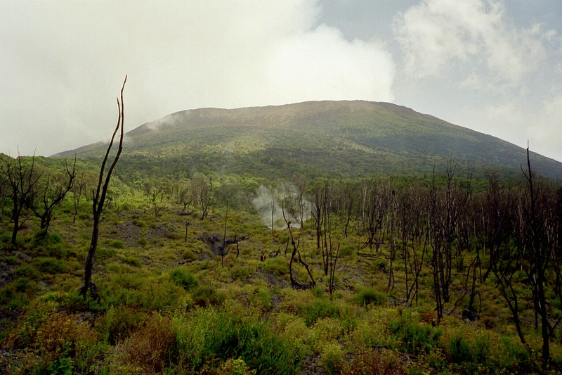
 Cone of the flanks of Mount Nyiragongo
Six months after the start of the 2002 eruption, Nyiragongo volcano erupted again. Activity at Nyiragongo is ongoing, but currently confined to the crater, where another lava lake has formed about 250 metres below the level of the 1994 lava lake.
See also
- List of volcanoes in the Democratic Republic of the Congo
- List of volcanic eruptions by death toll
References
- Notes
- ^ a b "Nyiragongo". Global Volcanism Program, Smithsonian Institution. http://www.volcano.si.edu/world/volcano.cfm?vnum=0203-03=.
- ^ a b c "Cooperative Observations at Nyiragongo Volcano in D.R. of Congo." Earthquake Research Institute, University of Tokyo. Accessed 3 September 2007.
- ^ Edmund Sanders, "'Killer Lake' Could Power Rwanda," Los Angeles Times, May 23, 2008.
- Bibliography
- Tazieff Haroun, Bichet Pierre (1979). Nyiragongo: The Forbidden Volcano. Barron's. pp. 288 pp. ISBN 0-8120-5296-X. OCLC 4114550.
- Allard P, Baxter P, Halbwachs M, Kasareka M, Komorowski JC, Joron JL (2003). "The most destructive effusive eruption in modern history: Nyiragongo 2003". Geophysical Research Abstracts 5: 11970.
- Demant A, Lestrade P, Lubala RT, Kampunzu AB, Durieux J (1994). "Volcanological and petrological evolution of Nyiragongo volcano, Virunga volcanic field, Zaire". Bulletin of Volcanology 56 (1): 47–60. Bibcode 1994BVol...56...47D. doi:10.1007/s004450050016.
- Rosbøg Sanne (2007-07-07). "Kvinde overlevede fald på 100 meter" (in (Danish)). http://ekstrabladet.dk/nyheder/samfund/article73101.ece.
- Favalli M, Chirico GD, Papale P, Pareschi MT, Coltelli M, Lucaya N, Boschi E (2006). "Computer simulations of lava flow paths in the town of Goma, Nyiragongo volcano, Democratic Republic of Congo". Journal of Geophysical Research 111 (B6): B06202. Bibcode 2006JGRB..11106202F. doi:10.1029/2004JB003527.
External links
- The Big Picture: Nyiragongo Crater
- Nyiragongo Volcano Video on France 24 TV
- Tourism at Nyiragongo Volcano
- Photos of Nyiragongo lava lake in January 2011
- Volcano World Nyiragongo page
- BBC News pictures of the destruction of Goma by the 2002 Eruption
- PBS Nova: "Volcano under the City"
- Recent photos from Nyiragongo and its lava lake
- Stromboli Online's expedition to Nyiragongo in May, 2005
- Alkali Basalt Association of the Continents
- Official Website of Virunga National Park
Decade Volcanoes Categories:- Active volcanoes
- Decade Volcanoes
- Volcanoes of the Great Rift Valley
- Mountains of the Democratic Republic of the Congo
- Stratovolcanoes
- Virunga Mountains
- Volcanoes of the Democratic Republic of the Congo
- VEI-2 volcanoes
- Lake Kivu
- Goma


Wikimedia Foundation. 2010.