- Mogocha
-
Mogocha (English)
Могоча (Russian)- Town[citation needed] - 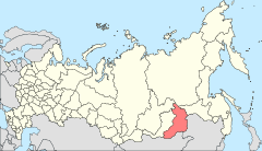
Location of Zabaykalsky Krai in Russia
 Mogocha
Coordinates: 53°44′N 119°46′E / 53.733°N 119.767°ECoordinates: 53°44′N 119°46′E / 53.733°N 119.767°E Administrative status Country Russia Federal subject Zabaykalsky Krai Administrative district Mogochinsky District[citation needed] Administrative center of Mogochinsky District[citation needed] Statistics Population (2010 Census,
preliminary)13,228 inhabitants[1] Population (2002 Census) 13,282 inhabitants[2] Time zone YAKST (UTC+10:00)[3] Founded 1910[citation needed] Postal code(s) 673730–673732[citation needed] Dialing code(s) +7 30241[citation needed] 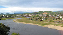

 Winter train stop in Mogocha
Mogocha (Russian: Мого́ча) is a town and the administrative center of Mogochinsky District of Zabaykalsky Krai, Russia, located at the confluence of the Mogocha and Amazar Rivers 709 kilometers (441 mi) northeast of Chita. Population: 13,228 (2010 Census preliminary results);[1] 13,282 (2002 Census);[2] 17,847 (1989 Census).[4]
Contents
History
It was founded in 1910, with the construction of the local section of the Trans-Siberian Railway. The name Mogocha is derived from the river on which it stands, whose name comes from the Evenk word Mongochi. This meaning of the word is ambiguous; it can be translated as "golden valley", but also as belonging to the Mongo tribe.
Rail traffic began in 1914. In addition to its status as a supply point for the railway, from the 1920s and 1930s it became the base for gold mining in the surrounding area.
Town status was granted to it in 1950.
From 1947 until 1953, the town was site for the Klyuchevlag prison labor camp of the gulag system. The camp held up to 3,000 prisoners at any one time, mainly used as forced labor for molybdenum and gold mining in the villages to the southwest of the town. This, combined with the harsh climactic conditions, gave rise to the local expression God created Sochi, and Satan Mogocha.
After the dissolution of the Soviet Union and subsequent economic crisis, Mogocha lost around one third of its population, a common occurrence for cities in the Russian Far East. At the same time, a significant number of Chinese citizens and companies have moved to the region.
Economy and infrastructure
Mogocha possesses a station on the Trans-Siberian railway. Other than railway-related industries, there is logging and timber milling conducted in the surrounding area.
Its small airport, which had opened in 1937, was closed during the 1990s.
References
- ^ a b Федеральная служба государственной статистики (Federal State Statistics Service) (2011). "Предварительные итоги Всероссийской переписи населения 2010 года (Preliminary results of the 2010 All-Russian Population Census)" (in Russian). Всероссийская перепись населения 2010 года (All-Russia Population Census of 2010). Federal State Statistics Service. http://www.perepis-2010.ru/results_of_the_census/results-inform.php. Retrieved 2011-04-25.
- ^ a b Федеральная служба государственной статистики (Federal State Statistics Service) (2004-05-21). "Численность населения России, субъектов Российской Федерации в составе федеральных округов, районов, городских поселений, сельских населённых пунктов – районных центров и сельских населённых пунктов с населением 3 тысячи и более человек (Population of Russia, its federal districts, federal subjects, districts, urban localities, rural localities—administrative centers, and rural localities with population of over 3,000)" (in Russian). Всероссийская перепись населения 2002 года (All-Russia Population Census of 2002). Federal State Statistics Service. http://www.perepis2002.ru/ct/doc/1_TOM_01_04.xls. Retrieved 2010-03-23.
- ^ Правительство Российской Федерации. Постановление №725 от 31 августа 2011 г. «О составе территорий, образующих каждую часовую зону, и порядке исчисления времени в часовых зонах, а также о признании утратившими силу отдельных Постановлений Правительства Российской Федерации». Вступил в силу по истечении 7 дней после дня официального опубликования. Опубликован: "Российская Газета", №197, 6 сентября 2011 г. (Government of the Russian Federation. Resolution #725 of August 31, 2011 On the Composition of the Territories Included into Each Time Zone and on the Procedures of Timekeeping in the Time Zones, as Well as on Abrogation of Several Resolutions of the Government of the Russian Federation. Effective as of after 7 days following the day of the official publication).
- ^ "Всесоюзная перепись населения 1989 г. Численность наличного населения союзных и автономных республик, автономных областей и округов, краёв, областей, районов, городских поселений и сёл-райцентров. (All Union Population Census of 1989. Present population of union and autonomous republics, autonomous oblasts and okrugs, krais, oblasts, districts, urban settlements, and villages serving as district administrative centers.)" (in Russian). Всесоюзная перепись населения 1989 года (All-Union Population Census of 1989). Demoscope Weekly (website of the Institute of Demographics of the State University—Higher School of Economics. 1989. http://demoscope.ru/weekly/ssp/rus89_reg.php. Retrieved 2010-03-23.
- Дворниченко Н. Е., Земля за Байкалом Иркутск, 1970.
External links
Administrative divisions of Zabaykalsky Krai Administrative center: Chita Cities and towns Baley · Borzya · Khilok · Krasnokamensk · Mogocha · Nerchinsk · Petrovsk-Zabaykalsky · Shilka · SretenskDistricts Akshinsky · Alexandrovo-Zavodsky · Baleysky · Borzinsky · Chernyshevsky · Chitinsky · Gazimuro-Zavodsky · Kalarsky · Kalgansky · Karymsky · Khiloksky · Krasnochikoysky · Krasnokamensky · Kyrinsky · Mogochinsky · Nerchinsko-Zavodsky · Nerchinsky · Olovyanninsky · Ononsky · Petrovsk-Zabaykalsky · Priargunsky · Shelopuginsky · Shilkinsky · Sretensky · Tungiro-Olyokminsky · Tungokochensky · Ulyotovsky · ZabaykalskyDistricts of
Agin-Buryat OkrugCategories:- Cities and towns in Zabaykalsky Krai


Wikimedia Foundation. 2010.