- West Somerset Mineral Railway
-
West Somerset Mineral Railway 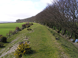
A view along the embankment from SS986354 looking westwards towards Gupworthy from the Withiel road underbridgeDates of operation 1856–1917 Track gauge 4 ft 8 1⁄2 in (1,435 mm) (standard gauge) The West Somerset Mineral Railway was a 4 ft 8 1⁄2 in (1,435 mm) (standard gauge) line which operated in the UK county of Somerset. It ran from the ironstone mines in the Brendon Hills to the port of Watchet on the Bristol Channel.[1] From there the ore was carried across by ship to Newport and thence to Ebbw Vale for smelting to extract the iron. The line's biggest feature was the 800-foot (243.8 m) gravity worked 1 in 4 (25%) incline used to descend the north side of the Brendon Hills.[2]
Contents
History
West Somerset Mineral Railway Legend

Watchet 


Taunton via Watchet 

West Somerset Railway 

Kentford 

Minehead via Washford 
Washford Roadwater 

Comberow 
Incline 
Winding House 
Former bridge on B3224 Brendon Hill 


Luxborough Road Raleigh Cross Mine 

Gupworthy The line was built in stages between 1856 and 1861, the construction of the incline taking the last two years of this period. It was operated by the West Somerset Mineral Company which also constructed a harbour wall at Watchet. At the top of the incline the line ran along the Brendon ridge in both directions, eastward to Raleigh's Cross and the Colton mines and westward to a heathland terminus named after the nearby village of Gupworthy.
The line operated successfully and settlements of people attracted to the area by the prospect of employment in the mines grew around the Brendon ridge. However changes in the availability of imported ore made the mines a less attractive proposition and by 1880 the mines were closed and the railway dormant. A residual passenger service carried on until 1898 when the line closed for a while.[1]
In 1907 another venture, the Somerset Mineral Syndicate, leased the railway and worked the mines again. Both the lower section of the line and the incline were brought back into use. However, the venture was under-capitalized and closed in March 1910.[1]
In 1911 an Australian inventor A.R. Angus used the lower section of the line to test and demonstrate an automatic signal warning device, but that was the last time the line was used. The UK Ministry for War requisitioned the rails during the First World War and they were lifted for scrap towards the end of the conflict.[1]
Locomotives
Two different types of locomotives were used during the first period of operation of the line. The smaller locomotives were 0-4-0ST tanks built by Neilson and Company. The earliest ones were 'box tanks' and two were delivered ready for the line's opening but one was replaced[3] following a fatal collision at Kentsford in August 1857.[4] One was returned to Ebbw Vale in 1883 but the fleet was increased to two once more in December 1896. They were usually found above the incline, below that point larger Sharp, Stewart 0-6-0STs were used. The first arrived in 1857 and a second in 1866. The original locomotive was sent to Ebbw Vale in 1883 but two other locomotives spent short spells at Watchet in the 1890s.[3]
When the line reopened in 1907 just one locomotive was used. This was a Beyer Peacock 4-4-0T built in 1879 for the Metropolitan Railway in London, it was number 37 of their A Class condensing locomotives. It arrived on the railway on 30 June 1907 by way of a temporary connection from the Great Western Railway (GWR) at Kentsford.[5]
The two tender locomotives used to demonstrate the Angus automatic train control equipment had originally been West Midland Railway 2-2-2s numbers 103 and 104. They were on WSMR from 17 December 1911 and used for a demonstration on 5 July 1912. On 4 November 1917 they were moved to Taunton where they were stored until 1919. After being sold to the Bute Works Supply Company in 1920 they were sold on to the Cambrian Railways in 1921[3][6] as their numbers 10 and 1.
Name/number Builder Works no. Built Wheels In use[3] – Neilson and Co. 370 1856 0-4-0ST 1856–c.1897 – Neilson and Co. ? ? 0-4-0ST 1857 Rowcliffe Sharp, Stewart 995 1857 0-6-0ST 1857–c.1883 – Neilson and Co. ? c.1861 0-4-0ST c.1865–1883 Pontypool Sharp, Stewart 1677 1866 0-6-0ST 1866–1899 Esperanza Sharp, Stewart 2262 1872 0-6-0ST c.1894 Whitfield Sharp, Stewart 1011 c.1857 0-6-0ST 1895 Newport[7] Neilson and Co. ? 1855 0-4-0ST 1896–c.1900 37 Beyer Peacock 1881 1879 4-4-0T 1907–1910 212 Beyer Peacock 248 1861 2-4-0 1911–1917 213 Beyer Peacock 249 1861 2-4-0 1911–1917 Colton Tramway
The 2 ft (610 mm) Colton Tramway was worked by two small locomotives, both of which faced Brendon Hill.
Name/number Builder Works no. Built Wheels In use[3] – W.G. Bagnall 210 1879 0-4-0T c.1907–1910 – Kerr Stuart 700 1900 0-4-0 c.1907–1910 Remains of the line
 The former winding house at the top of the incline, which runs down to the right
 Gupworthy station site; the end of the line is at the camera position and the alignment runs from bottom left to the centre of the image; the white house was probably the Station House
Today the line can still be seen in places, although some of it is private property. It runs parallel to the West Somerset Railway from Watchet to Washford[8] where it forms a foot and cycle path. It then curves south west, partly in the form of a road, past Cleeve Abbey and Roadwater village to Combe Row. The yard that was at the foot of the incline is clearly identifiable here at Comberow to the west of the bridge that carried the incline. Part of the line northwards from there seems to be a footpath.
The incline from there is not visible because of tree growth and it is difficult to get access to it without unreasonable encroachment on private property, although the OS map shows a public footpath crossing the incline about two-thirds of the way up. The remains of the summit winding house are reasonably accessible with care. This is located just west of the junction of the B3224 and B3190 roads. A chapel built to attend to the spiritual needs of the miners and their families still stands at the junction.
The line is located in the Exmoor National Park, and funds have been made available for conservation through the Heritage Lottery Fund and other sources.[9] Work has been undertaken on the incline winding house and trees cleared from the incline.[10]
The line continued west to Gupworthy with modest earthworks, and bridge abutments can be seen where minor roads cross the alignment.
There is a private house at the former Gupworthy station (at SS963356) that was probably the railway house and the alignment is visible there.
See also
References
- Sellick, Roger 1962. The West Somerset Mineral Railway. David & Charles. No ISBN.
- ^ a b c d "Station Name: WATCHET". Subterranea Britannica. http://www.subbrit.org.uk/sb-sites/stations/w/watchet/index.shtml. Retrieved 19 November 2007.
- ^ "West Somerset Mineral Railway". Industrial Railway Record. http://www.irsociety.co.uk/Archives/26/WSMR.htm. Retrieved 19 November 2007.
- ^ a b c d e Hately, Roger, ed (1977). Industrial Locomotives of South Western England. Handbooks. Greenford: Industrial Railway Society. p. 73. ISBN 0-901096-23-7.
- ^ Sellick, R.J. (1981) [1976]. The Old Mineral Line. Wellington: Halsgrove. p. 5. ISBN 978-1-84114-692-8.
- ^ Sellick, R.J. (1981) [1976]. pp. 38–40.
- ^ Sellick, R.J. (1981) [1976]. p. 50.
- ^ "Newport, temporary replacement locomotive in Somerset in 1896". West Somerset Mineral Railway Project. http://www.westsomersetmineralrailway.org.uk/welcome/images-and-drawings/search/?entryid45=9089. Retrieved 18 April 2011.
- ^ "The Old Mineral Line". OS Explorer. http://explore.ordnancesurvey.co.uk/os_routes/show/217. Retrieved 19 November 2007.
- ^ "West Somerset Mineral Railway Heritage Project". Exmoor National Park. http://www.exmoor-nationalpark.gov.uk/index/news_static/2006_apr_3.htm. Retrieved 19 November 2007.
- ^ "West Somerset mineral line railway". funicular railways of the UK. http://www.hows.org.uk/personal/rail/incline/bhi.htm. Retrieved 19 November 2007.
Further reading
- Dale, Peter. Somerset's Lost Railways. Stenlake Publishing. ISBN 1-84033-171-2.
- Ordnance Survey Map: Explorer OL9 Exmoor (The top of the incline is at Grid Reference ST023344)
External links
Categories:- Early British railway companies
- Rail transport in Somerset
- Closed railway lines in South West England
- Railway lines opened in 1861


Wikimedia Foundation. 2010.