- Barranquitas, Puerto Rico
Infobox Settlement
settlement_type =
subdivision_type = Country
subdivision_name =United States
subdivision_type1 = Territory
subdivision_name1 =Puerto Rico
subdivision_type2 =
subdivision_name2 =
timezone=AST
utc_offset=-4
timezone_DST=
utc_offset_DST=
unit_pref=Imperial
map_caption =Location of Barranquitas, Puerto Rico within Puerto Rico.
latNS=N
longEW=W| official_name = Barranquitas, Puerto Rico | nickname = Cuna de Próceres", "Cuna Feria de Artesanías", "El Altar de la Patria", "El Pueblo de Luis Muñoz Rivera
image_
| population_blank1 = Barranquiteños|population_blank1_title=Gentilic| | population_blank1 = Barranquiteños|population_blank1_title=Gentilic|
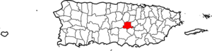
| map_caption = Location within the island ofPuerto Rico
established_date = 1803 | leader_title|established_title=Founded| =Mayor | leader_title=Mayor
leader_name = Hon. Francisco "Paco" López
political party = Partido Nuevo Progresista
leader_party = PNP
leader_title1=Senatorial dist.
leader_name1= Guayama
leader_title2=Representative dist.
leader_name2 = 27| area_magnitude = | area_total_km2 = 86.01
area_land_km2 = 86| area_water_km2 = .01| population_as_of = 2000 | population_note =
population_total = 28909|population_footnotes= | population_density_km2 = 327.0| timezone = AST | utc_offset = -4 | timezone_DST = | utc_offset_DST = -4| latd= |latm= |lats=
longd=|longm= |longs=
latitude =
longitude =
website =
footnotes = Anthem – "Aquí en el centro de nuestra tierra" |Barranquitas (bahr-rahn-KEE-tahs) is a small mountain town located in the central region, north of Corozal and Naranjito; south of Coamo and Aibonito; east of Comerio; and west of Orocovis. Barranquitas is spread over 6 wards and Barranquitas Pueblo (The downtown area and the administrative center of the city).
Barranquitas is about one hour by winding roads from San Juan, the capital. It is nestled amid hills and mountains, and nearby, between Barranquitas and Aibonito, is located the "cañon de San Cristobal" (Canyon of San Cristopher); one of the deepest canyons in the Indies. For years, the overlook was tragically used as a municipal garbage; in the last decade, the refuse was carted out and the site restored.
Barranquitas (bahr-rahn-KEE-tahs) is a small mountain town located in the central region, south of Corozal and Naranjito; north of Coamo and Aibonito; west of Comerio; and east of Orocovis.
History
Barranquitas's local Taino Indian Cacique (Chief) was called
Orocobix and his yucayeque or tribe was known as theJatibonicu Taino .The town was founded in 1803 by Antonio Aponte Ramos.
Early in the 20th century, Barranquitas residents, known as "Barranquiteños", had a short but legendary territory war with residents of the city of Comerío.
Flag
Three horizontal stripes of equal width form the flag of Barranquitas: white superior represents the silver color on the shield), the green center and the yellow bottom represents the gold color)
Coat of Arms
The gorges resemble the San Cristóbal Gorge, located in the territorial division of the municipalities of Barranquitas and Aibonito. The yagrumo trees characteristic of the mountainous zone of Puerto Rico, symbolize the elevation above sea level of Barranquitas, one of the highest elevations within the municipalities of the island. The three tower crown represents cities, towns or municipalities.
Demographics
Barrios (Districts/Wards) [http://welcome.topuertorico.org/maps/barranquitas.pdf]
Geo/Topography
Rivers: Barranquitas, Grande de Manatí, La Plata, Piñonas, Rio Hondo, and Usabón.
Anthem
Aquí en el centro de nuestra tierra,
entre montañas de gran verdor,
sonríe glorioso mi Barranquitas,
el pueblecito de mi pasión.Perla brillante del Torrecilla,
de ambiente plácido, acogedor;
mi Barranquitas, cuna de ilustres,
muy gloria tuya, fue Muñoz.La suave brisa de sus montañas
bien le acaricias con tierno amor,
la luz radiante del sol le baña,
le canta el ave dulce canción.Perla brillante del Torrecilla,
de ambiente plácido, acogedor;
mi Barranquitas, cuna de ilustres,
muy gloria tuya fue Muñoz.Economic
Agriculture
Agriculture of Barranquitas includes coffee, fruits, vegetables and flowers.
Industry
Barranquitas manufacturers include footwear and clothing.
Tourism
Landmarks and places of interest
Barranquitas is the burial place of two Puerto Rican prominent politicians,
Luis Muñoz Rivera (who was born in town) and his son, Governor,Luis Muñoz Marín (who was born in San Juan). This has made Barranquitas a popular tourist attraction among Puerto Ricans. The birthplace of Muñoz Rivera has been turned into a museum.*Camp Morton
*El Cortijo Castle
*Hacienda Grande Ruins
*Luis Muñoz Rivera Cultural Center
*Luis Muñoz Rivera Museum
*San Cristóbal GorgeFestivals and events
*De la Vega Festival - May
*San Antonio de Padua Patron Festivities - June
*National Artesans Fair- Julyports
Barranquitas has no professional sports teams, but there are some amateur sports teams that play there. A yearly craft fair is held in town.
Notable "Barranquiteños"
*Antonio Aponte Ramos
*Efraín Colón Torres
*Luis Muñoz Marín - Governor of Puerto Rico
*Luis Muñoz Rivera - Politician, journalist and poet
*José A. Negrón Sanjurjo
*José Colón
*Naldo de la Loma - Escultor
*Pedro Pereales
*Clara Lair
*José Muñoz Marín - Poet
*Ileana Perez Ortiz- Productora MusicalReferences
External links
* [http://www.topuertorico.org/city/barran.shtml Welcome to Puerto Rico Barranquitas]
* [http://www.puertohost.com/maps/barranquitas-map.php Map of Barranquitas Puerto Rico]
Wikimedia Foundation. 2010.