- Mourne Mountains
-
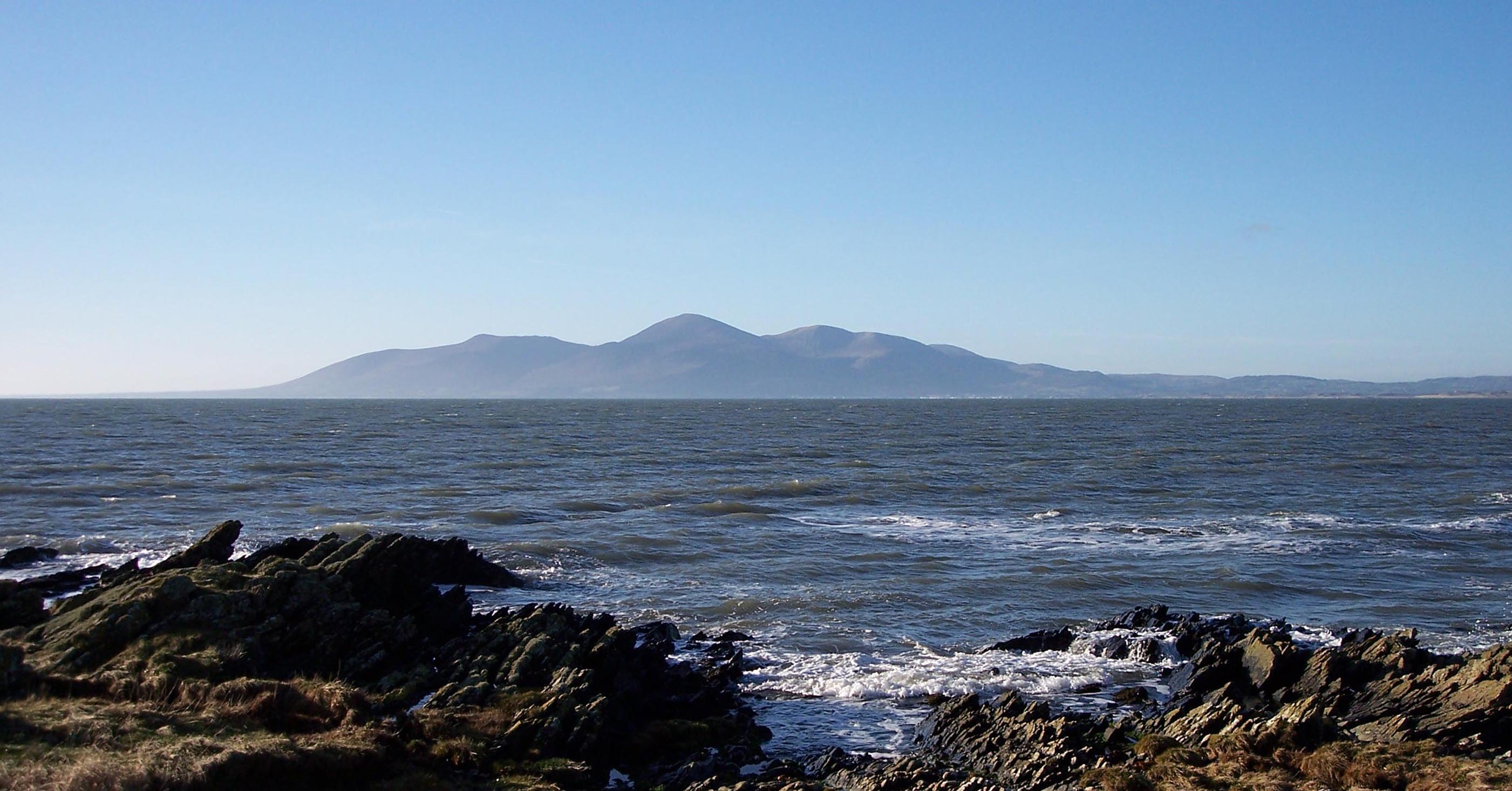
Mourne Mountains Na Beanna Boirche Range  View of the Mournes from St John's Point, County Down
Sovereign state United Kingdom Constituent country Northern Ireland Counties County Down Highest point Slieve Donard - elevation 849 m (2,785 ft) Geology Granite The Mourne Mountains (also called the Mournes or Mountains of Mourne – pronounced morn ) are a granite mountain range in County Down in the south-east of Northern Ireland. It includes the highest mountains in Northern Ireland and the province of Ulster. The highest of these is Slieve Donard at 852 metres (2,795 ft). The Mournes is an area of outstanding natural beauty and has been proposed as the first national park in Northern Ireland. The area is partly owned by the National Trust and see a large number of visitors every year. The name Mourne (historically spelt Morne) is derived from the name of a Gaelic clann or sept called the Múghdhorna.[1][2]
Contents
The mountains
The Mournes are visited by many tourists, hillwalkers, cyclists and rock climbers. Following a fundraising drive in 1993, the National Trust purchased nearly 1,300 acres (5.3 km2) of land in the Mournes. This included a part of Slieve Donard and nearby Slieve Commedagh, at 767 metres (2,516 ft) the second-highest mountain in the area.
 The Mourne Wall, looking towards Hare's Gap
The Mourne Wall is among the more famous features in the Mournes. It is a 35 kilometres (22 mi) dry-stone wall that crosses fifteen summits, constructed to define the boundaries of the 36 square kilometres (8,900 acres) area of land purchased by the Belfast Water Commissioners in the late 1800s. This followed a number of Acts of Parliament allowing the sale, and the establishment of a water supply from the Mournes to the growing industrial city of Belfast. Construction of the Mourne Wall was started in 1904 and was completed in 1922.
Some of the mountains have names beginning Slieve, from the Irish word sliabh, meaning mountain. Examples are Slieve Donard, Slieve Lamagan and Slieve Muck. There are also a number of curious names: Pigeon Rock; Buzzard's Roost; Brandy Pad; the Cock and Hen; Percy Bysshe; the Devil's Coach Road; and Pollaphuca, which means "hole of the fairies or sprites".
The Mournes are very popular as a destination for many Duke of Edinburgh's Award expeditions.
Vegetation and wildlife
 Panorama of Silent Valley Reservoir in the Mournes
Aside from grasses, the most common plants found in the Mournes are heathers. Of these, three species are found: the cross-leaved heath (erica tetralix), the bell heather (erica cinerea), and the ling (calluna vulgaris). Other plants which grow in the area are: Bog Cotton, Roseroot (Rhodiola rosea), Harebell (Campanula rotundifolia), Marsh St John's Wort, Wild Thyme (Thymus serpyllum), Wood sorrel and Heath Spotted Orchids.
Sheep graze high into the mountains, and the range is also home to birds, including the common Raven, Peregrine Falcon, Wren, and Buzzard, and native Meadow Pipit, Grey Wagtail, Stonechat and Snipe. The Golden Eagle, a former inhabitant, has not been seen in the Mournes since 1836.
Possible national park status
It has been proposed that the Mourne Mountains be made Northern Ireland's first national park.[3][4] The plan has been subject to controversy because of the area's status as private property, with over 1,000 farmers based in the proposed park,[4] and also because of fears over the impact on local communities, bureaucracy and house prices.[5]
Popular culture
The mountains are immortalised in a song written by Percy French in 1896, "The Mountains of Mourne". The song has been recorded by many artistes, including Don McLean.
The Mourne Mountains also influenced C.S. Lewis to write The Lion, The Witch and The Wardrobe.[6]
Recreation
The Mournes are a very popular area for hiking, the Wall providing a convenient navigation aid.
There are a large number of granite cliffs, in the form of outcrops and tors, scattered throughout the range, making the Mournes one of Ireland's major rock-climbing areas since the first recorded ascents in the 1930s. The rock forms are generally quite rounded, thus often depending on cams for protection, but with good friction. The 1998 guidebook lists 26 separate crags, with a total of about 900 routes of all grades.[7][8] Bill Moseley - horror movie icon, has climbed the mountains of Mourne. He has listed his hike as one of his favourite places he has visited and hopes to return again.
See also
References
- ^ Joyce, Patrick. The origin and history of Irish names of places. 1869. p.128
- ^ Placenames Database of Ireland
- ^ "Minister paves the way for national park in the Mournes". Northern Ireland Planning Service. 2002-09-25. http://www.planningni.gov.uk/index/news/news_releases/news_newsreleases_archive/news_releases_2002/news_release_mournes_250903.htm. Retrieved 2009-10-11.
- ^ a b Peterkin, Tom (2007-08-29). "Mourne Mountains national park status row". Daily Telegraph. http://www.telegraph.co.uk/earth/earthnews/3304922/Mourne-Mountains-national-park-status-row.html. Retrieved 2009-10-11.
- ^ Cassidy, Martin (2007-02-23). "Community split over national park". BBC News. http://news.bbc.co.uk/1/hi/northern_ireland/6388157.stm. Retrieved 2009-10-11.
- ^ Discover Northern Ireland: Mourne Mountains Page
- ^ "Irish Climbing Online Wiki - Co. Down". http://wiki.climbing.ie/index.php/Irish_Climbing_Route_Database#Co._Down. Retrieved 2011-04-07.
- ^ Robert Bankhead, ed. (1998), Mournes: MCI Guide, Mountaineering Ireland, ISBN 0 902940 14 7
- Kirk, David (2002). The Mountains of Mourne: A Celebration of a Place Apart. Belfast: Appletree Press. ISBN 086281846X.
External links
- About the Mourne Mountains
- The website of the book above under 'References'
- A local family's site with some information about the mountains
- Mournes Climbers
- Photos, maps and commentary of the walk around the Mourne Wall
- BBC article about the Mourne Wall
Mountains and hills of Ulster List of mountains in Ireland Antrim Hills 
Antrim Plateau Belfast Hills Croaghgorms Derryveagh Inishowen Mournes Sperrins Southwest Donegal Others England Wales Scotland Northern Ireland Mourne Mountains†An area with ‡ has similar status to a UK National Park. Areas marked † are proposed. Categories:- Areas of Outstanding Natural Beauty in Northern Ireland
- Climbing areas of Ireland
- Mountains and hills of County Down
- Protected areas of County Down


Wikimedia Foundation. 2010.