- Maryport
-
Coordinates: 54°42′46″N 3°29′33″W / 54.7128°N 3.4926°W
Maryport 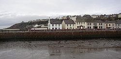
Maryport Harbour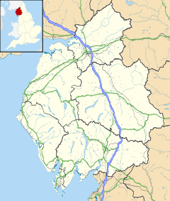
 Maryport
Maryport shown within CumbriaPopulation 11,275 (2001) OS grid reference NY038363 Parish Maryport District Allerdale Shire county Cumbria Region North West Country England Sovereign state United Kingdom Post town MARYPORT Postcode district CA15 Dialling code 01900 Police Cumbria Fire Cumbria Ambulance North West EU Parliament North West England UK Parliament Workington List of places: UK • England • Cumbria Maryport is a town and civil parish within the Allerdale borough of Cumbria, England, in the historic county of Cumberland. It is located on the A596 road north of Workington, and is the southernmost town on the Solway Firth. Maryport railway station is on the Cumbrian Coast Line. The town is in the parliamentary constituency of Workington. Maryport lies at the northern end of the former Cumberland Coalfield.
Contents
History
Roman and medieval times
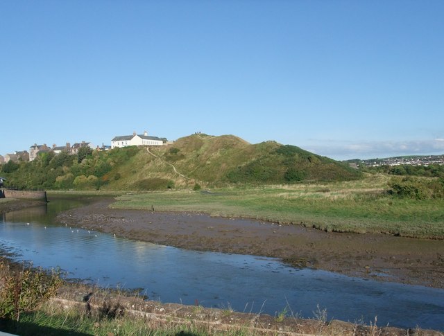
Main article: Alauna (Maryport)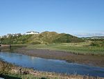 Maryport Castle Hill
The town was first established as the Roman fort Alauna in around AD 122 as a command and supply base for the coastal defences of Hadrian's Wall at its western extremity. There are substantial remains of the Roman fort, which was the last in a series of forts stretching southwards along the coast from Hadrian's Wall, aimed at preventing the wall being avoided by a crossing of the Solway Firth. Recent geomagnetic surveys have revealed a large Roman town surrounding the fort. A recent archaeological dig discovered evidence of a second, earlier and larger fort next to, and partially under the present remains. After the Roman withdrawal from Britain the town was soon reduced in size and importance.
On Castle Hill are the earthworks and buried remains of a twelfth century motte and bailey castle. On the summit are the foundations of a World War II gun emplacement.
To the north are the ruins of Netherhall Estate. The only remains of this once grand manor are stables and a fourteenth century Peel Tower, formerly part of a large house of later date which was demolished in 1979 following a fire.
Georgian times
For many years the town was named Ellenfoot but the name was changed by Humphrey Senhouse as he began developing the town as a port, following the example of Whitehaven. In 1749 an Act of Parliament was passed to allow the creation of the present town. Humphrey Senhouse named the new town after his wife Mary. The Senhouse family were landowners in the area and responsible for the development of the town and excavation of its Roman past. The family also had interests in the West Indies. In 1770, Humphrey Senhouse’s son, William, was appointed Surveyor General of Customs in Barbados where he purchased a sugar plantation and managed another for Sir James Lowther of Whitehaven. William’s brother, Joseph, had a coffee plantation in Dominica. Both men were considerable slave-owners.[1]
It was during this period that the town's lighthouse was built.
Victorian times
The town quickly developed as an industrial centre throughout the 19th century. An iron foundry opened and the port developed as did shipyards, such as Wood's yard and Ritson's yard, which was famous for launching ships broadside into the River Ellen because it was not wide enough to allow ships to be launched the usual way. By this time, coal mines were operating all around the town – at Ellenbough, Dearham, Broughton Moor, Gilcrux and Birkby.
The Maryport & Carlisle Railway, opened in the 1840s, with George Stephenson as its engineer, made the transport of coal much easier. Large new mines were sunk in the Aspatria area and almost all their production passed through the port. In 1846, 213,152 tons of coal were shipped from Maryport and by 1857 this had risen to more than 340,000 tons. Much of the coal produced in the area was turned into coke for the local iron and steel industry. By 1890, the Allerdale Coal Company had thirty Beehive coke ovens working on its site at Buckhill, Broughton Moor.
In 1874, the owners announced a cut of 10% in the miners’ wages. A strike began in the Aspatria pits and then the owners made a further cut of 15%. By December, the strike had spread to the whole area with 2,000 men involved. The strike lasted until March 1875. There was violence when some ‘blacklegs’ were assaulted and many colliers left the area to seek work elsewhere. In 1894, John Osmaston who operated the Dearham Colliery became insolvent and the bank took over his pits. Two groups of local miners formed co-operatives and leased the mines at Crosshow and Townhead from the Lowthers. They found it impossible to compete with the other wealthy coal-owners in a tight market and also had serious problems with drainage. This unique experiment ended in 1903 when both companies went into liquidation.[2]
Modern times
During the early years of the 20th century, trade in the docks remained steady but was badly affected by the 1926 United Kingdom General Strike. Then, in 1927, a new deep-water dock was opened in Workington. Previously, the Workington Iron and Steel works had imported much of their raw material through Maryport but all of this trade was immediately transferred to the new facility. The local Solway Blast Furnaces also closed.[3]
Maryport became a ghost town. The government declared West Cumberland a ‘Special Area’ but, by 1933, 57.3% of the town’s insured workforce was unemployed. 1,684 men were out of work. Maryport was “for the most part, living on public funds”[4]
Despite a minor boom during the Second World War, when coal from North East England was diverted to the port, Maryport never recovered. The docks were closed to cargo ships in the 1960s. The last deep pit in the area, at Risehow, closed in 1966 and open-cast mining ended in 2000.
Today, after a series of major regeneration projects, prospects for the town are looking better.[5]
Politics
The town is a mainly Labour voting area, although far right parties such as the British National Party have tried to make inroads.
Economy
Tourism is now the main business in Maryport. There is an aquarium, a maritime museum and a Roman museum. The latter houses numerous Roman artefacts, most notably a series of altars to Jupiter Optimus Maximus, which were excavated in the 18th century from the parade ground of the Roman fort.
In July 2008, a new tourism venue, The Wave Centre, opened its doors. The Wave Centre is a theatre and conference facility, an interactive heritage exhibition on the local history of Maryport, the Tourist Information Centre for Maryport, and a gift shop and bistro.
Maryport Golf Club was formed on January 21, 1905 and is now a well established 18 hole course.[6]
Culture
The town is a major name on the blues music scene, holding the popular "Maryport Blues Festival" every summer, This has previously attracted names such as Jools Holland, Dionne Warwick, Elkie Brooks, Buddy Guy, Jethro Tull, Van Morrison and Chuck Berry. The three-day event usually takes place on the last weekend of July, attracting both local and international artists.
The town has a Scout Group (2nd Maryport) that has been in the town for over 70 years and incorporates most sections within the Scouting Movement. The Group was visited by the Bishop of Carlisle to mark the centenary of Scouting in 2008.
Education
Maryport has one secondary school, Netherhall School, Maryport. The school has approximately 790 students on role.
Notable people
Notable past residents of Maryport have included:
- Douglas Clark
- Thomas Henry Ismay
- Fletcher Christian
- George Tosh
- Mark Heron
- Seán Milroy
- Tom Smith
- James Lomas
References
- Biggins, J. A. and Taylor, D. J. A., 2004b, The Roman Fort and Vicus at Maryport: Geophysical Survey, 2000–2004, in R. J. A. Wilson and I, Caruana (eds.), Romans on the Solway, CWAAS for the Trustees of the Senhouse Museum, Maryport, 102-133.
- ^ Richard B. Sheridan: Material relating to the West Indies from the Senhouse Papers, University of Kansas, 1977.
- ^ Oliver Wood: West Cumberland Coal 1600-1982 (Cumberland and Westmorland Antiquarian and Archaeological Society, 1988)
- ^ J.Y. Lancaster & D.R. Wattleworth: The Iron and Steel Industry of West Cumberland (British Steel Corporation, 1977)
- ^ John Jewkes and Allan Winterbottom: An Industrial Survey of Cumberland & Furness (Manchester University Press, 1933)
- ^ http://www.allerdale.gov.uk/business/regeneration/regeneration-projects.aspx
- ^ [1], Maryport Golf Club Website
External links
- Index of Maryport Sailing Ships
- article on the Maritime Museum
- Maryport local information and news website
- Maryport Blues website
- The Wave Centre website
- Maryport Golf Club website
- iRomans Link to a website showing a selection of roman objects from Maryport stored with collection at Tullie House Museum.
- Senhouse family in the West Indies
Ceremonial county of Cumbria Cumbria Portal Boroughs or districts City of Carlisle • Borough of Allerdale • Borough of Barrow-in-Furness • Borough of Copeland • District of Eden • District of South LakelandMajor settlements Alston • Ambleside • Appleby-in-Westmorland • Aspatria • Barrow-in-Furness • Bowness-on-Windermere • Brampton • Broughton-in-Furness • Carlisle • Cleator Moor • Cockermouth • Dalton-in-Furness • Egremont • Grange-over-Sands • Harrington • Kendal • Keswick • Kirkby Lonsdale • Kirkby Stephen • Longtown • Maryport • Millom • Penrith • Sedbergh • Silloth • Ulverston • Whitehaven • Wigton • Windermere • Workington
See also: List of civil parishes in CumbriaTopics Demography • Economy • Education • Geography • History • People • Places of interest • Settlements • Sport • Symbols and county emblems • TransportCategories:- 120s establishments
- Towns in Cumbria
- Populated coastal places in Cumbria
- Civil parishes in Cumbria


Wikimedia Foundation. 2010.