- Col de l'Iseran
-
Col de l'Iseran 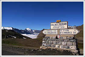
Signpost at the Col de l'IseranElevation 2,770 m (9,088 ft) Traversed by D 902 road Location Location of Col de l'Iseran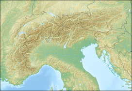
 Col de l'Iseran
Location Savoie,  France
Range Graian Alps Coordinates 45°25′1″N 07°01′51″E / 45.41694°N 7.03083°ECoordinates: 45°25′1″N 07°01′51″E / 45.41694°N 7.03083°E Col de l'Iseran (elevation 2770 m) is the highest paved mountain pass in the Alps. A part of the Graian Alps, it is situated in the department of Savoie in France near the border with Italy. It is crossed by the D902.
The pass is part of the Route des Grandes Alpes. It connects the valley of the Isère and the valley of the Arc River between Val-d'Isère in the north and Bonneval-sur-Arc in the south. The north side of the pass road is well built with a number of galleries and tunnels, with a maximum grade of 12 percent.
On the north, are the popular ski resorts of Tignes and Val-d'Isère.
The pass is only accessible by road during the summer months. In the winter it falls within the Espace Killy ski area and is easily accessed by a series of pistes and ski lifts.
Contents
Details of the climb
From the north the road goes up and down and through tunnels past the lake of Tignes. Starting from Bourg-Saint-Maurice, the Col de l'Iseran is 48 km long. Over this distance, the climb is 1955 m (an average percentage of 4.1%). The last part of the climb starts at Val-d'Isère: 15 km at a consistent average of 6% (climbing 895 m).
From the south, the climb starts at Lanslebourg-Mont Cenis and is 32.9 km long. Over this distance, the climb is 1371 m (an average percentage of 4.2%). The final part of the climb starts at Bonneval-sur-Arc: 13.4 km at an average of 7.3%. (climbing 977 m) with several sections in excess of 10%.
The Tour de France
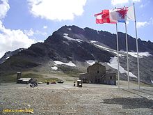 Flags at the summit
The Col d'Iseran was first used in the Tour de France in 1938 - the first rider over the summit was Felicien Vervaecke, but on the descent he was passed by Gino Bartali who had taken the leader's yellow jersey from Vervaecke the previous day and retained it all the way to the finish in Paris.
The following year, in the 1939 tour, the first mountain time trial was introduced to the tour, over the Col d'Iseran from Bonneval-sur-Arc to Bourg-Saint-Maurice, which was won by Sylvere Maes by a margin of four minutes.
Since 1947 the pass has been used four times on the Tour de France. It was scheduled to be used in 1996, but was left out at the last minute due to bad weather. As a result of snow on both the Col de l'Iseran and the Col du Galibier, the scheduled 190 km stage from Val-d'Isère to Sestriere in Italy was truncated and reduced to a 46 km sprint from Le-Monetier-les-Bains which was claimed by Bjarne Riis, resulting in him taking the yellow jersey which he retained to the finish in Paris.
In 2007, Col d'Iseran was climbed on stage 9 of the Tour de France, starting from Val-d'Isère.
Appearances in Tour de France
Year Stage Category Leader at the summit 2007 9 HC Yaroslav Popovych 1992 13 HC Claudio Chiappucci 1963 16 1 Fernando Manzaneque 1959 18 1 Adolf Christian 1949 17 1 Joseph Tacca 1939 16b ITT Sylvere Maes 1938 14 Felicien Vervaecke References
External links
Categories:- Mountain passes of the Alps
- Mountain passes of France
- 2007 Tour de France
- Climbs in cycle racing
- Mountains of Savoie


Wikimedia Foundation. 2010.