- Cwmllynfell
-
Cwmllynfell Ordnance Survey OS grid reference: Maps for SN747127 Geography Total population 1,126 (2001 census) Administration Local council: Neath Port Talbot County Borough Council Number of councillors]: 1 Nation: Wales Post office and telephone Postcode(s): SA9 Dialling code: +44-1639 Politics Welsh Assembly: Neath UK Parliament: Neath European Parliament: Wales Cwmllynfell is the name of a village, community and electoral ward in Neath Port Talbot county borough, Wales.
Amenities
Cwmllynfell has its own local rugby union team - Cwmllynfell RFC. Also, a Welsh Primary School, CK's Supermarket, Post Office, village hall, church, chapel(s) and a grooming parlour (Newly added). Nearby there are the Black Mountains, which supply stunning views to the village. Welsh is commonly spoken in these regions.
The electoral ward consists of some or all of the following areas: Blaen-nant, Bryn-Melyn, Celliwarog, Cwmllynfell, Rhiw-fawr in the parliamentary constituency of Neath. Cwmllynfell is bounded by the wards of Quarter Bach of Carmarthenshire to the northeast; Cwmtwrch of Powys to the east; Ystalyfera to the southeast; Pontardawe to the southwest; Gwaun-Cae-Gurwen to the west and Lower Brynamman to the northwest.
In the 2008 local council elections, Councillor C E Richards of the Labour Party was returned unopposed.
External links
Neath Port Talbot Neath Port Talbot County Borough Council Communities Aberavon · Baglan Bay · Blaengwrach · Blaenhonddan · Briton Ferry · Bryn · Cilybebyll · Clyne · Coedffranc · Crynant · Cwmavon · Cwmllynfell · Dyffryn Clydach · Glyncorrwg · Glynneath · Gwaun-cae-Gurwen · Margam · Margam Moors · Neath · Onllwyn · Pelenna · Pontardawe · Port Talbot · Resolven · Sandfields East · Sandfields West · Seven Sisters · Tai Bach · Tonna · Ystalyfera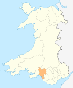
Towns and villages Aberavon · Aberdulais · Abergarwed · Alltwen · Baglan · Blaengwrach · Blaenhoddan · Cadoxton · Cilfrew · Cilybebyll · Clyne · Cwmgors · Cwmllynfell · Crynant · Glynneath · Godre'r Graig · Goytre · Groes · Llangiwg · Lonlas · Lower Brynamman · Margam · Melincourt Falls · Morfa Glas · Neath · Pontardawe · Port Talbot · Resolven · Rhiwfawr · Rhydyfro · Seven Sisters · Skewen · Tairgwaith · Tonna · YstalyferaCastles Rivers Electoral wards of Neath Port Talbot county borough Aberavon Neath Aberdulais · Allt-Wen · Blaengwrach · Bryncoch North · Bryncoch South · Cadoxton · Cimla · Crynant · Cwmllynfell · Dyffryn · Glynneath · Godre'r Graig · Gwaun-Cae-Gurwen · Lower Brynamman · Neath East · Neath North · Neath South · Onllwyn · Pelenna · Pontardawe · Resolven · Rhos · Seven Sisters · Tonna · Trebanos · Ystalyfera
Communities of Neath Port Talbot county borough Aberavon · Baglan · Baglan Bay · Blaengwrach · Blaenhonddan · Briton Ferry · Bryn · Cilybebyll · Clyne and Melincourt · Coedffranc · Crynant · Cwmafan · Cwmllynfell · Dyffryn Clydach · Glyncorrwg · Glynneath · Gwaun-Cae-Gurwen · Margam · Margam Moors · Neath · Onllwyn · Pelenna · Pontardawe · Port Talbot · Resolven · Sandfields East · Sandfields West · Seven Sisters · Taibach · Tonna · Ystalyfera
Categories:- Glamorgan geography stubs
- Electoral wards of Neath Port Talbot
- Communities in Neath Port Talbot
- Villages in Neath Port Talbot

Wikimedia Foundation. 2010.