- River Coquet
-
Coordinates: 55°22′05″N 2°20′53″W / 55.368°N 2.348°W
River Coquet 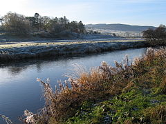
River Coquet near Rothbury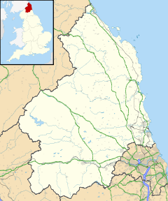
 Source of the River Coquet
 River Coquet shown within Northumberland
OS grid reference NT780083 List of places: UK • England • Northumberland River Coquet
SettlementsThe River Coquet
 /ˈkoʊkət/ runs through the county of Northumberland, England, discharging into the North Sea on the east coast of England at Amble. Warkworth Castle is built in a loop of the Coquet.
The river, about 40 miles (64 km) in length, rises in the Cheviot Hills and follows a course generally easterly, but greatly winding. It passes Harbottle, near which relics of the Stone Age are seen, and Holystone, where it is recorded that Bishop Paulinus baptized a great body of Northumbrians in the year 627. Several earthworks crown hills above this part of the valley and at Cartington, Tosson and Whitton are relics of medieval border fortifications.
The small town of Rothbury is beautifully situated beneath the rugged Simonside Hills. The river dashes through a narrow gully called the Thrum, and then passes Brinkburn Priory, of which the fine Transitional Norman church was restored to use in 1858, while there are fragments of the monastic buildings. This was an Augustinian foundation of the time of Henry I.
A short distance below this the Coquet has its mouth in Warkworth Harbour, with the small port of Amble on the south bank, and Coquet Island a mile out to sea. The river is frequented by sportsmen for salmon and trout fishing. No important tributary is received, but nine smaller tributaries do join the river at intervals, including Usway Burn and the River Alwin.
The earliest known reference to the River Coquet is found in the 7th Century Ravenna Cosmography, where it is known as Coccoveda. Bede referred to Cocuedi fluminis.[1] This can be roughly translated to 'Red River', perhaps reflecting the red porphyritic pebbles found here in large numbers.[2]
See also
- Rivers of the United Kingdom
- Bridges On the Coquet
- The Roman Map of Britain - Coccuveda
References
 This article incorporates text from a publication now in the public domain: Chisholm, Hugh, ed (1911). Encyclopædia Britannica (11th ed.). Cambridge University Press.Categories:
- Rivers of Northumberland
- Northumberland geography stubs


Wikimedia Foundation. 2010.