Clayton (St. Louis MetroLink)

Clayton (St. Louis MetroLink)
Clayton
Clayton MetroLink station.jpg
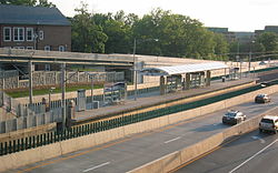
Station statistics
Address 275 South Central Ave
St. Louis, Missouri 63105
Lines
  Blue Line
Platforms Island platform
Parking 800 incremental paid park and ride spaces at Shaw Park Garage
Other information
Opened August 26, 2006
Accessible Handicapped/disabled access
Owned by Bi-State Development Agency dba Metro
Traffic
Passengers (FY2007) 923 daily steady 0%
Services
Preceding station   St. Louis MetroLink   Following station
Blue Line

Clayton is a St. Louis MetroLink station that opened August 26, 2006. This at-grade station is located in the median of Forest Park Parkway between S. Central Ave and S. Meramec Ave, and serves the Clayton Central Business District, St. Louis County Government Complex and area residents. MetroRide, a convenient shop for customers to receive schedule and route information or purchase tickets and passes, is located at this station on the second level. This station is accessible by pedestrian access bridge, stairs, and an elevator. All bus connections are located in the adjacent Clayton MetroBus Center, accessible by elevator or escalator from second level of the garage.

Contents

Bus connections

MetroBus

  • 1 WUSTL-Gold
  • 47 North Hanley
  • 58 Clayton-Ballas
  • 66 Clayton-Airport
  • 97 Delmar
  • 258 Clayton-Chesterfield
  • Metro Call-A-Ride

Parking

Public parking is available in the attached county garage. However, this parking is not supplied by Metro, therefore charges may apply; from August 28, 2006, parking in this garage will be included in the new 30-day "Metro Combo Pass." [1]

External links

Coordinates: 38°38′44″N 90°20′20″W / 38.645668°N 90.338852°W / 38.645668; -90.338852


Wikimedia Foundation. 2010.

Игры ⚽ Поможем решить контрольную работу

Look at other dictionaries:

  • Forsyth (St. Louis MetroLink) — Infobox Station name=Forsyth image size= image caption= address=7411 Forsyth Blvd. St. Louis, Missouri 63105 line=St. Louis MetroLinkrail color box|system=STML|line=Shrewsbury other= platform=Side platforms tracks= parking= bicycle= baggage check …   Wikipedia

  • St. Louis MetroLink — Infobox Public transit name = St. Louis MetroLink imagesize = 100px locale = St. Louis metropolitan area transit type = Light rail began operation = July 31, 1993 system length = 46 mi (74 km) lines = 2 stations = 37 ridership = 67,684 (FY 2007)… …   Wikipedia

  • Brentwood I-64 (St. Louis MetroLink) — Infobox Station name=Brentwood I 64 image size= image caption= address=8398 Eager Road St. Louis, Missouri 63144 line=St. Louis MetroLinkrail color box|system=STML|line=Shrewsbury other= platform= tracks= parking=926 park ride spaces (26 long… …   Wikipedia

  • Lambert Airport Main (St. Louis MetroLink) — Infobox Station name=Lambert Airport Main image size= image caption= address=10701 Lambert International Airport Blvd. St. Louis, Missouri 63145 line=St. Louis MetroLinkrail color box|system=STML|line=Main other= platform=Island platform tracks=… …   Wikipedia

  • Clayton Hall Metrolink station — For the rapid transit station located in St. Louis, Missouri, see Clayton (St. Louis MetroLink).  Clayton Hall Manchester Metrolink Location Place …   Wikipedia

  • St. Louis MetroLink — 38° 37′ 32″ N 90° 13′ 15″ W / 38.62565, 90.22073 …   Wikipédia en Français

  • MetroLink (St. Louis) — Not to be confused with Metrolink (Southern California). MetroLink A view of the MetroLink system passing through Bellevil …   Wikipedia

  • Clayton, Missouri —   City   Location in Mi …   Wikipedia

  • MetroBus (St. Louis) — MetroBus Slogan Connecting People With Places Found …   Wikipedia

  • Washington University in St. Louis — Infobox University name = Washington University in St. Louis image size = 250px latin name = Universitas Washingtoniana motto = Per veritatem vis mottoeng = Strength through truth established = February 22, 1853 type = Private calendar = Semester …   Wikipedia

Share the article and excerpts

Direct link
Do a right-click on the link above
and select “Copy Link”