- Milecastle 48
-
 The remains of Milecastle 48
 Turret 48A
 Turret 48B
Milecastle 48 , one of the milecastles on Hadrian's Wall, is situated in the village of Gilsland in Cumbria immediately adjacent to the Tyne Valley Line (OS grid reference NY 634 661). It is known locally as "The King's Stables"[1] but in recent years the heritage industry has begun to call it Poltross Burn Milecastle.
It measures 18.5m east to west by 21.3m north to south and two barracks buildings are visible, one either side of the main north to south road. It is built with broad gauge defensive walls, including stub 'wing walls' which join onto the Narrow Wall curtain of Hadrian's Wall on either side. It has Type III gateways. It lies 1521m west of Milecastle 47 and 1458m east of Milecastle 49.
The distinguishing feature of this milecastle is the stair base in the north-east corner, since the first few steps survive, allowing a wall walk height of 3.6m to be projected, suggesting a height for the curtain wall (including parapet) of 4.6m.
Milecastle 48 was excavated by J.P. Gibson and F.G. Simpson in 1909. (Gibson, 1911) The monument is currently in the care of English Heritage.
This milecastle was built by the Sixth Legion but manned by auxiliary troops, and was occupied until the Fourth Century AD, all according to the English Heritage placard at the site.
Nature of Hadrian's Wall in this reach
Milecastle 48 is connected to well-preserved stone-built sections of Hadrians Wall, which continue several miles to the west, at least as far as Banks.
References
- Derivation of place-name
- Gibson, J.P. & Simpson, F.G. 1911. Art XXIII – The Milecastle on the Wall of Hadrian at the Poltross Burn; Trans. CWAAS XI (New Series) pp390–461
External links
 Media related to Milecastle 48 at Wikimedia Commons
- Visit Cumbria A good aerial photo of Milecastle 48
Milecastles of Hadrian's Wall Milecastles 0 • 1 • 2 • 3 • 4 • 5 • 6 • 7 • 8 • 9 • 10 • 11 • 12 • 13 • 14 • 15 • 16 • 17 • 18 • 19 • 20 • 21 • 22 • 23 • 24 • 25 • 26 • 27 • 28 • 29 • 30 • 31 • 32 • 33 • 34 • 35 • 36 • 37 • 38 • 39 • 40 • 41 • 42 • 43 • 44 • 45 • 46 • 47 • 48 • 49 • 50 • 50TW • 51 • 52 • 53 • 54 • 55 • 56 • 57 • 58 • 59 • 60 • 61 • 62 • 63 • 64 • 65 • 66 • 67 • 68 • 69 • 70 • 71 • 72 • 73 • 74 • 75 • 76 • 77 • 78 • 79 • 80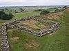
Milefortlets MF 1 • MF 2 • MF 3 • MF 4 • MF 5 • MF 6 • MF 7 • MF 8 • MF 9 • MF 10 • MF 11 • MF 12 • MF 13 • MF 14 • MF 15 • MF 16 • MF 17 • MF 18 • MF 19 • MF 20 • MF 21 • MF 22 • MF 23 • MF 24 • MF 25 • MF 26Other structures on Hadrian's Wall Portgate • Chesters Bridge • Knag Burn Gateway • Peel Gap Tower • Willowford Bridge • Pike Hill Signal TowerCoordinates: 54°59′20″N 2°34′25″W / 54.9890°N 2.5735°W

This article relating to archaeology in the United Kingdom is a stub. You can help Wikipedia by expanding it. This Ancient Rome-related article is a stub. You can help Wikipedia by expanding it. This article about a Cumbria building or structure is a stub. You can help Wikipedia by expanding it.


