- Milecastle 49
-
 The remains of Milecastle 49
 Turret 49B
Milecastle 49 (Harrow's Scar), one of the milecastles on Hadrian's Wall, is situated immediately west of the gorge of the River Irthing (OS grid reference NY 620 664), where the Wall was carried over the river by the bridge at Willowford.
It measures 19.8m east to west by 22.9m north and no contemporary internal buildings are now visible. It is built with narrow gauge defensive walls which are bonded with the Narrow Wall curtain of Hadrian's Wall on either side. It has Type III gateways. It lies 1458m west of Milecastle 48 and 1391m east of Milecastle 50.
Parts of the underlying Turf Wall milecastle (49TW) were identified by Richmond.
It was excavated in 1898 and by I.A. Richmond in 1953.
The monument is currently in the care of English Heritage. It was designated as a Scheduled Monument (number:13987) on 14 July 1997.[1]
References
External links
 Media related to Milecastle 49 at Wikimedia Commons
Milecastles of Hadrian's Wall Milecastles 0 • 1 • 2 • 3 • 4 • 5 • 6 • 7 • 8 • 9 • 10 • 11 • 12 • 13 • 14 • 15 • 16 • 17 • 18 • 19 • 20 • 21 • 22 • 23 • 24 • 25 • 26 • 27 • 28 • 29 • 30 • 31 • 32 • 33 • 34 • 35 • 36 • 37 • 38 • 39 • 40 • 41 • 42 • 43 • 44 • 45 • 46 • 47 • 48 • 49 • 50 • 50TW • 51 • 52 • 53 • 54 • 55 • 56 • 57 • 58 • 59 • 60 • 61 • 62 • 63 • 64 • 65 • 66 • 67 • 68 • 69 • 70 • 71 • 72 • 73 • 74 • 75 • 76 • 77 • 78 • 79 • 80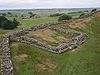
Milefortlets MF 1 • MF 2 • MF 3 • MF 4 • MF 5 • MF 6 • MF 7 • MF 8 • MF 9 • MF 10 • MF 11 • MF 12 • MF 13 • MF 14 • MF 15 • MF 16 • MF 17 • MF 18 • MF 19 • MF 20 • MF 21 • MF 22 • MF 23 • MF 24 • MF 25 • MF 26Other structures on Hadrian's Wall Portgate • Chesters Bridge • Knag Burn Gateway • Peel Gap Tower • Willowford Bridge • Pike Hill Signal Tower
This article relating to archaeology in the United Kingdom is a stub. You can help Wikipedia by expanding it. This Ancient Rome-related article is a stub. You can help Wikipedia by expanding it. This article about a Cumbria building or structure is a stub. You can help Wikipedia by expanding it.


