- Sokoto
Infobox Settlement
official_name =Sokoto
other_name =
native_name =
nickname =
settlement_type =
motto =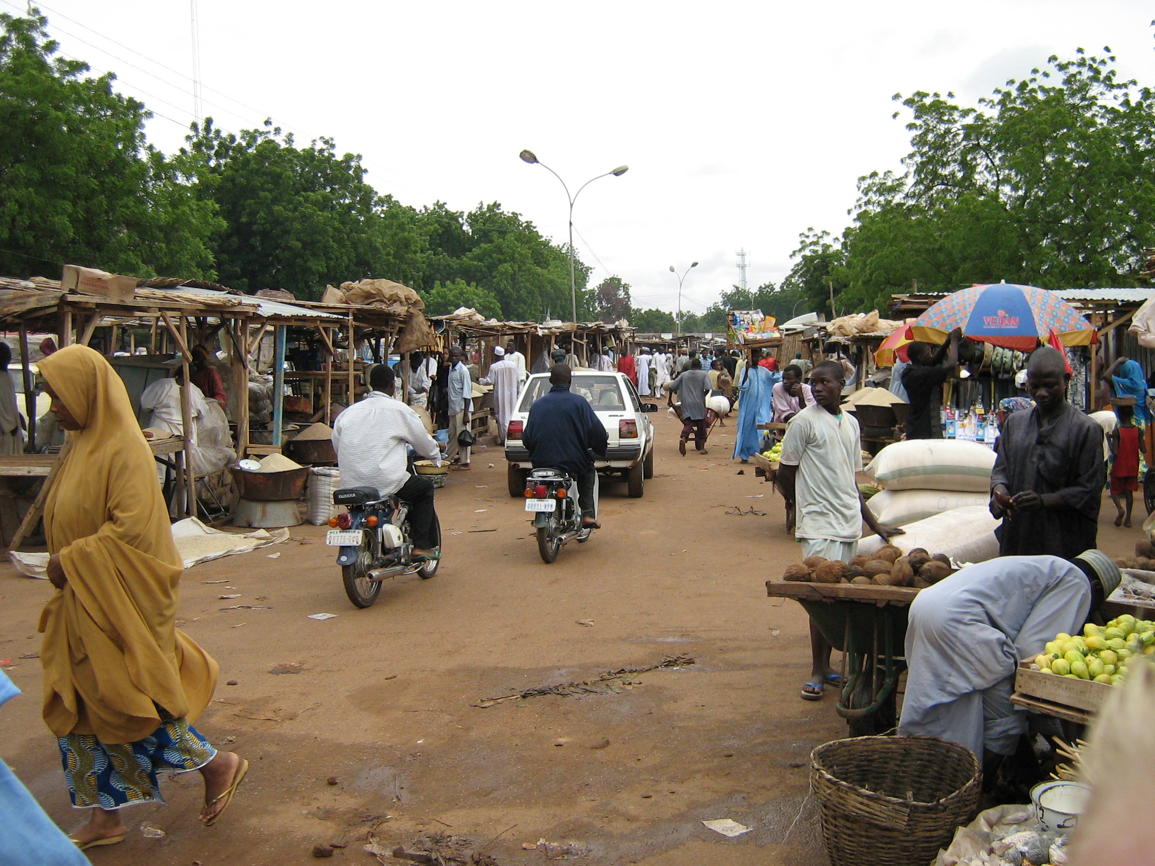
imagesize = 300px
image_caption = Sokoto market 2006
flag_size =
image_
seal_size =
image_shield =
shield_size =
image_blank_emblem =
blank_emblem_type =
blank_emblem_size =
mapsize =
map_caption =
mapsize1 =
map_caption1 =
image_dot_
dot_mapsize =
dot_map_caption =
dot_x = |dot_y =
pushpin_
pushpin_label_position =bottom
pushpin_map_caption =Location in Nigeria
subdivision_type = Country
subdivision_name =
subdivision_type1 = State
subdivision_name1 =Sokoto State
subdivision_type2 =
subdivision_name2 =
subdivision_type3 =
subdivision_name3 =
subdivision_type4 =
subdivision_name4 =
government_footnotes =
government_type =
leader_title =
leader_name =
leader_title1 =
leader_name1 =
leader_title2 =
leader_name2 =
leader_title3 =
leader_name3 =
leader_title4 =
leader_name4 =
established_title =
established_date =
established_title2 =
established_date2 =
established_title3 =
established_date3 =
area_magnitude =
unit_pref =Imperial
area_footnotes =
area_total_km2 =
area_land_km2 =
area_water_km2 =
area_total_sq_mi =
area_land_sq_mi =
area_water_sq_mi =
area_water_percent =
area_urban_km2 =
area_urban_sq_mi =
area_metro_km2 =
area_metro_sq_mi =
area_blank1_title =
area_blank1_km2 =
area_blank1_sq_mi =
population_as_of =2006
population_footnotes =
population_note =
population_total =583,039
population_density_km2 =
population_density_sq_mi =
population_metro =
population_density_metro_km2 =
population_density_metro_sq_mi =
population_urban =
population_density_urban_km2 =
population_density_urban_sq_mi =
population_blank1_title =Ethnicities
population_blank1 =
population_blank2_title =Religions
population_blank2 =
population_density_blank1_km2 =
population_density_blank1_sq_mi =
timezone =
utc_offset =
timezone_DST =
utc_offset_DST =
latd=13 |latm=04 |lats= |latNS=N
longd=5 |longm=14 |longs= |longEW=E
elevation_footnotes =
elevation_m =
elevation_ft =
postal_code_type =
postal_code =
area_code =
blank_name =
blank_info =
blank1_name =
blank1_info =
website =
footnotes =Sokoto is a city located in the extreme northwest of
Nigeria , near to where theSokoto River andRima River meet. As of 2006 it has a population of 583,039 [http://www.bevölkerungsstatistik.de/] . Sokoto is the modern day capital ofSokoto State (and its predecessor, the Northwestern State).The name Sokoto (which is the modern/anglicised version of the local name, "Sakkwato") is of Arabic origin, representing "suk", 'market'. It is also known as "Sakkwato, Birnin Shaihu da Bello" or "Sokoto, Capital of Shaihu and Bello").
Being the seat of the
Sokoto Caliphate , the city is predominantly Muslim and an important seat of Islamic learning in Nigeria. The Sultan who heads the caliphate is effectively the spiritual leader of Nigerian Muslims.History
Originally the capital of the
Hausa kingdom ofGobir , established around the 10th century, Sokoto was one of the seven walledHausa Kingdoms . In the 13th century, Islam arrived from the north by way of the trans-Saharan caravan routes.cite book| title = The Bradt Travel Guide | last = Williams | first = Lizzie | date = 2005 | pages = 323]In 1809, Fulani chief and
Islam ic leaderUsman dan Fodio chose Sokoto as the capital of theSokoto Caliphate cite web | title = Encyclopædia Britannica | url = http://www.britannica.com/eb/article-9068546/Sokoto | accessdate = 2007-04-07] that ruled most of Northern Nigeria from the period ofUsman dan Fodio 's 1804-1812 "jihad " until its defeat at the hands ofFrederick Lugard 'sRoyal West African Frontier Force in 1903.cite web | title = British Conquest of the Sokoto Caliphate 1903 | url = http://www.onwar.com/aced/data/sierra/sokotocaliphate1903.htm | accessdate = 2007-04-07] The city has an estimated population of 601,893 people as of2007 .cite web | title = The World Gazetteer | url = http://www.world-gazetteer.com/wg.php?men=gpro&des=gamelan&geo=371070524 | accessdate = 2007-04-07]Since its creation as a state in 1976, Sokoto state has been ruled by governors, most ex-military officers, who succeeded each another at short intervals.
Sokoto, as a region, knows a longer history. During the reign of the Fulani Empire in the 19th century Sokoto was an important Fula state, in addition to being a city, of what was then west central Sudan.
From ca. 1900, with the British take-over, Sokoto, which then encompassed the entire north-west corner of Nigeria, became a province of the British protectorate of Nigeria. Not long after Gando was added as a sub-province. This double province then covered an area of 35,000 square miles (90,000 km²) with an estimated population over 500,000. It included the then Zamfara and Argunga, or Kebbi, kingdoms.
In the year 2000, Islamic
Shari'ah was introduced in several northern states of Nigeria including Sokoto State. While in principle these Islamic laws exclusively apply to Muslims, they've had consequences for all the Sokoto residents, such as, the ban on selling alcohol and the closure of film theaters in the State.Climate
Sokoto is in the dry
Sahel surrounded by sandysavannah and isolated hills.With an annual average temperature of 28.3°C, Sokoto is one of the hottest cities in the world, however the maximum daytime temperatures are most of the year generally under 40°C, and the dryness makes the heat bearable.cite web | title = A Brief History and Geoography of Sokoto State | url = http://www.sokoto-state.com/state.html | accessdate = 2007-04-07] The warmest months are February to April, where daytime temperatures can exceed 45°C. Highest recorded temperature is 47.2C, which is also the highest recorded temperature in Nigeria.The rainy season is from June to October, during which showers are a daily occurrence. The showers rarely last long and are a far cry from the regular torrential showers known in many tropical regions. From late October to February, during the 'cold season', the climate is dominated by the
Harmattan wind blowingSahara dust over the land. The dust dims the sunlight, thereby lowering temperatures significantly and also leading to the inconvenience of dust everywhere in the house.The region's lifeline for growing crops is the floodplains of the Sokoto-Rima river system, which are covered with rich
alluvial soil . For the rest, the general dryness of the region allows for few crops,millet perhaps being the most abundant, complemented by maize, rice, other cereals, and beans. Apart from tomatoes, few vegetables grow in the region. The low variety of foodstuffs available has resulted in the relatively dull local cuisine.In the city
Sokoto is probably best known for its Islamic spiritual and educational environment, housing the Sultan's Palace, the large
Shehu Mosque as well as numerous other mosques in the region. In Sokoto, recreational facilities are scarce and much of the social life revolves around activities in mosques and churches.Sokoto is also well known for its large market, where traders, farmers, craftsmen and just about anyone offer their goods in hundreds if not thousands of small stalls. The more noteworthy products sold here are leather goods and camels. In April 2006, the previously well-organized market burned down.cite web | title = Flagging off for Reconstruction of Sokoto State Central Market | url = http://www.sokoto-state.com/news39.html | accessdate = 2007-04-07] Currently, while the old market is being rebuilt, the market continues as a chaotic assemblage of stalls.
The city furthermore has one university, one polytechnic, one college of education and an airport 10 km south of the city.
Electricity, water, and sanitation
Sokoto, like much of the region gets most of its power from the
Kainji Dam , some 200 km southwest of Sokoto. The Nigerian power authority (NEPA), which provides electricity in the country, is often humorously spelled out as 'Never Expect Power Always' and thebackronym certainly applies to Sokoto. Power outages are a daily occurrence, often lasting for hours or longer. Many customers have electricity for a limited number of hours a day, and many are not connected to the grid at all. Due to the low reliability of power, many businesses have a reserve generator they employ during outages.Running (cold) water is widely available, though as with electricity it is often restricted to certain hours a day.
The city has a sewer system. As in much of Nigeria, there is inadequate organized garbage collection, and plastic refuse litters the streets everywhere.
Transport
Sokoto lacks a public transport system. Transport within the city (when not by foot) is mainly by mopeds which operate as one-person taxis. Buses and taxis are infrequent and are generally only used for transport between cities.
10 km south of Sokoto there is an international airport with regular connections to
Abuja ,Kano andLagos .Industry
In August 2008, an agreement was signed for the construction of a cement works in Sokoto.
See also
*
Sokoto Caliphate
*Usman dan Fodio
*Cement in Africa References
* [http://www.fallingrain.com/world/NI/51/Sokoto.html FallingRain Map - elevation = 272m]

Wikimedia Foundation. 2010.