- Neighborhoods of Tulsa, Oklahoma
-
Main article: Tulsa, Oklahoma
Contents
Downtown
 Downtown Tulsa
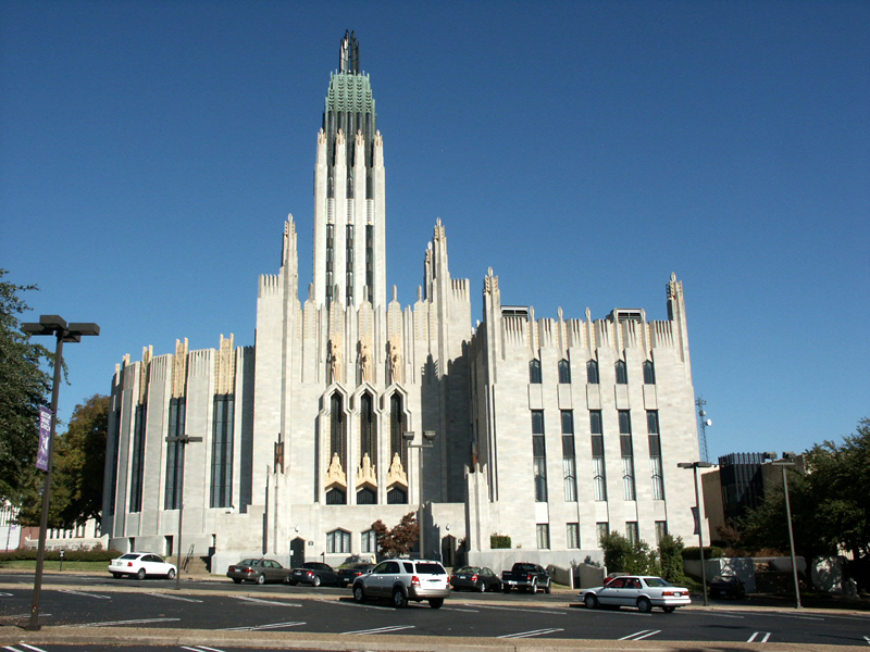
Tulsa includes many structures built during the Oil Boom in the 1920s and 1930s, including Art Deco buildings such as the Midcontinent Tower, Boston Avenue Methodist Church, and the Exchange Bank Building (today known as the 320 Boston Building). Oilman Waite Phillips, left a significant architectural impact on downtown Tulsa through the Philtower and Philcade buildings. Other notable Tulsa buildings include the Atlas Life building, Christ the King Catholic Church, Holy Trinity Greek Orthodox Church, and the Mayo Hotel, the former of which once served as home to J. Paul Getty. Known for a time as "Terra Cotta City",[1] Tulsa hosted the International Sixth Congress on Art Deco in 2001.
 Boston Avenue Methodist Church
Downtown Tulsa is in the northwest quadrant of the city and is ringed by an expressway system called the inner dispersal loop. Downtown's buildings include many large office towers. At 667 ft (203 m), the BOK Tower (formerly One Williams Center) is the tallest building in any of the 5 "plains states" (Oklahoma, Kansas, Nebraska, North Dakota and South Dakota) and was designed in 1975 by Minoru Yamasaki & Associates, the same architect who designed the World Trade Center in New York.
The Tulsa Performing Arts Center occupies a half city block in Tulsa's historical downtown. The PAC is also the design of Minoru Yamasaki. It houses five theatres and a reception hall. More than a quarter of a million people visit the Center each year to attend a performance from one of Tulsa's seven acclaimed musical and dramatic companies including the Tulsa Ballet, Tulsa Symphony Orchestra, Tulsa Opera, and a variety of symphonic groups. The PAC hosts a multitude of cultural events through the fall, winter and spring.
In 2005 the City of Tulsa broke ground on a 19,199 seat regional events center designed by architect César Pelli. The arena was named the BOK Center (or Bank of Oklahoma Center) and opened on August 30, 2008.
Brady Arts District
The Brady Arts District is located north across the Sante Fe Railroad tracks from the central business district and centered at Main Street & Brady Avenue. The Brady District is one of Tulsa's oldest areas, characterized by two-story brick warehouses.
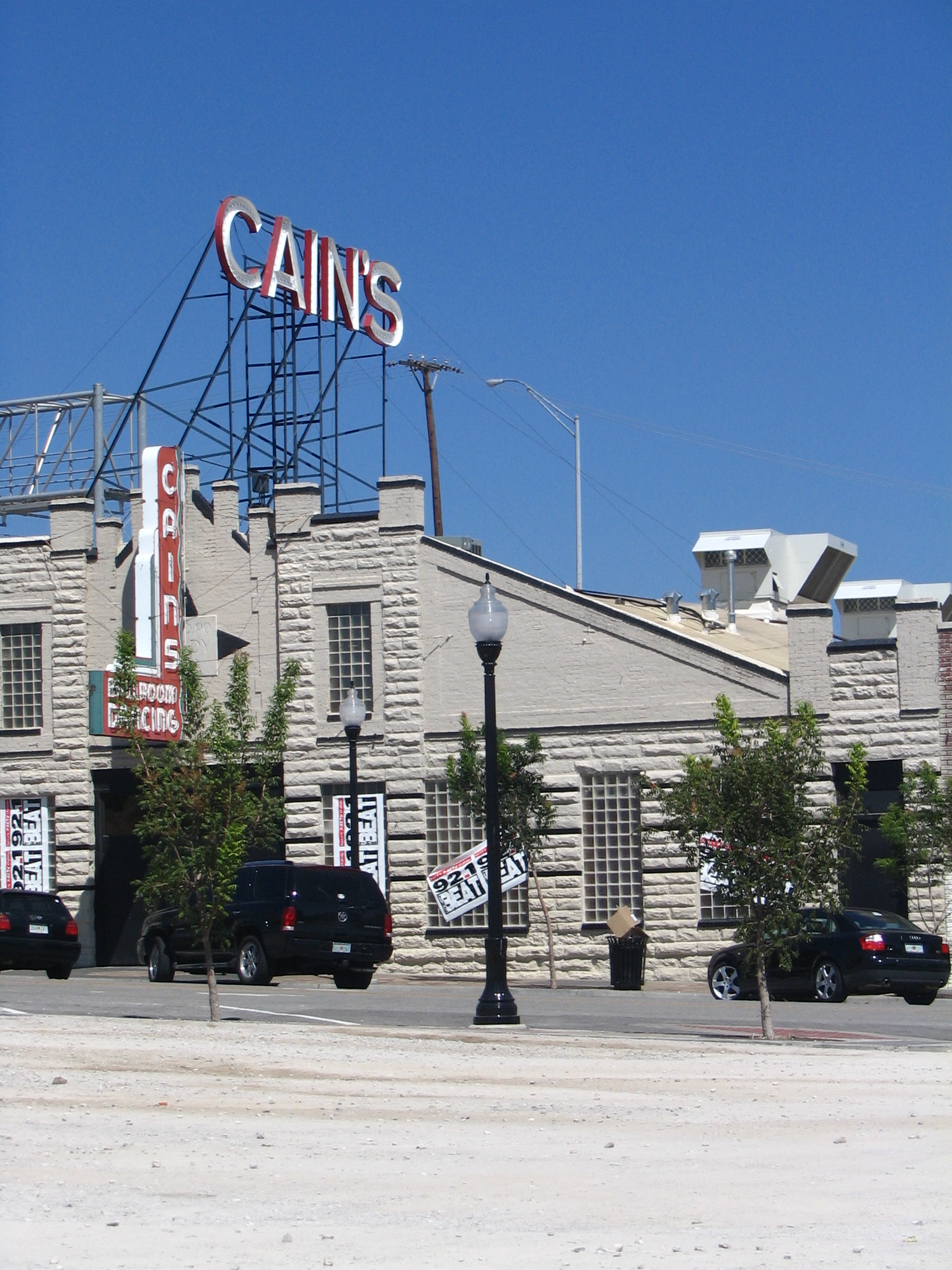
 Cain's Ballroom
The Brady Theater, built between 1912 and 1914, was originally designed to serve as the city's municipal auditorium and was simply called "Convention Hall" for the first forty years of its life and was one of three internment camps where African Americans were detained after the 1921 Tulsa Race Riot. In 1952, major additions were added and the building was renamed Tulsa Municipal Theater. The building was listed on the National Register of Historic Places in 1979. Supplanted as the city auditorium in 1979 by construction of the Performing Arts Center in downtown, "the Old Lady on Brady" continues to be used today for a wide variety of concerts and theatrical productions.
North of the Brady on Main Street is the Cain's Ballroom, formerly the garage of the Brady family[2] and the home of Bob Wills and his band, the Texas Playboys. The district is also the location of many local artists' galleries, restaurants with late night hours, bars and dance clubs.
Today, The Brady Arts District is one of the most diverse areas in all of Tulsa. It hosts restaurants, clubs, museums, and businesses and is a prime example of urban living. There is presently construction which will more than double the number of permanent residents in this artistic conclave. On its present path, the area will continue to develop as a hub of the community welcoming all people as it acknowledges its past while looking to a vibrant and inclusive future.
 The Blue Dome, a former Gulf Oil Service Station, built in 1924.
Blue Dome District
Another popular downtown entertainment district is the Blue Dome, named for a distinctive, domed building at Second Street and Elgin Avenue, in the area in the eastern section of downtown. The building was originally constructed in 1924 as a Gulf Oil service station. It has been converted to a grill, and is about one block south of the OneOK field. Every July, the Diversafest Music Festival & Conference takes over the Blue Dome District. The surrounding streets are blocked off as tens of thousands of music fans descend on the area for two days of music showcases of every genre on over 10 different stages.
East Village
East Village comprises 115 acres bordered by East 2nd and East 7th Streets, Detroit Avenue and Lansing Avenue, just inside the inner-dispersal loop.[3] This area boasts an upscale martini bar, a hair salon, a pet day care, photography studios, lofts, a knitting room and living arts district, among others. The cornerstone of this neighborhood is now the second largest LGBT community center in Oklahoma, the Dennis R. Neill Equality Center, owned and operated by Oklahomans for Equality/OkEq (formerly Tulsa Oklahomans for Human Rights/TOHR), with further development being planned for more restaurants, residential lofts and retail.
Oil Capital Historic District
The Oil Capital Historic District was added to the National Register of Historic Places in 2010. It is bounded by Third Street on the north, Seventh Street on the South, Cincinnati Avenue on the east and Cheyenne Avenue on the west. This area contains many of the historic Downtown office buildings constructed during the 1920s and 1930s.[4]
Riverview/Uptown
 Riverview, along the Arkansas River in Tulsa
Riverview stretches along the east bank of the Arkansas River, just west of Downtown. Uptown is the region just to the south of Downtown. The SoBo (South Boston) bar district in this area at 18th and south Boston is quite popular.
 Ambasador Hotel (14th Street side)
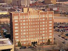
The Ambassador Hotel, now listed on the National Register of Historic Places, was built in 1929 to provide temporary housing for businessmen and now functions as a boutique hotel. The building is at the corner of Main and 14th Street. The Tulsa Preservation Commission identified this location as "...the Southeast Business Area of the Riverview section of Tulsa."[5]
Midtown
Midtown is a largely residential district in the heart of the city. This area consists mostly of homes built from the early 1900s to the 1950s and has a wide variety of American styles ranging from the Craftsman bungalow to the ranch-style home to Greek Revival. The neighborhood is even home to a relocated saltbox home from colonial New England. Schools in this part of the city include Bishop Kelley, Edison Preparatory School, Eliot Elementary, Francis Scott Key Elementary, Monte Cassino, Robert E. Lee Elementary, Patrick Henry Elementary, Wright Elementary and Undercroft Montessori. Woodward Park, located in Midtown, is known for its azaleas and gardens and is a popular destination for photography and picnics. Other popular Midtown Parks include Swan Lake, Zink Park, Darlington Park and Whiteside Park.
Utica Square, Tulsa's first suburban shopping center, is an upscale outdoor center with a mix of locally owned retailers, including Miss Jackson's, Tulsa's oldest department store, and national chains such as Saks Fifth Avenue. Adjacent to Utica Square is Temple Israel, a Reform Jewish congregation housed in a building by prolific synagogue architect Percival Goodman, and Cascia Hall Preparatory School, a college preparatory school now also known as a key location in the fantasy/horror House of Night novel series written by P.C. Cast and Kristin Cast. Tulsa's conservative synagogue, B'nai Emunah, is also located in Midtown.
 A courtyard in Utica Square
Some of the other major shopping centers in this part of the city include the Promenade Mall, Highland Park Shopping Center, Southroads, Ranch Acres, The Farm Shopping Center, and The Plaza. OU-Tulsa is across the street from the Promenade Mall at 41st and Yale, on the southern edge of Midtown.
In northeast Midtown, the Tulsa State Fairgrounds, now called Expo Square, is home to several Tulsa landmarks. In addition to the site being the former home to the minor league baseball Tulsa Drillers, the Art Deco Expo Square Pavilion, the Fair Meadows horse racing track, and the annual Tulsa State Fair, it boasts the Quick Trip Expo Center, the largest clearspan building in the world, providing 354,000 square feet (33,000 m²) of column-free space under a cable-suspended roof. In front of the Expo Center is the Golden Driller, standing 76 feet (23 m) tall. Built in 1966 as a symbol for the International Petroleum Expo, the statue serves as a reminder of Tulsa's oily past.
The Expo Center is also home to the annual Darryl Starbird Rod and Custom Show. Held in early February, it is touted as 'The World's Largest Indoor Car Show' and often draws around 1,500 custom and classic cars, trucks, and motorcycles. Antique car auctions are also held here and draw many visitors from across the nation.
Arkansas River Parks
The Tulsa area boasts nearly 40 miles (64 km) of river shoreline along the Arkansas River. River Parks lines more than 20 miles (32 km) of that stretch, spread along both banks of the 1/4 mile wide channel and connected by a pedestrian bridge between 21st and 31st streets. River Parks is a popular destination for outdoor recreation. Miles of asphalt-surfaced recreation trails weave past picnic areas, playgrounds, fountains and sculptures. The park's landscape ranges from manicured lawns to the rugged terrain of the Turkey Mountain Urban Wilderness Area. Recreation in River Parks includes fishing, rowing, kayaking, disc golf, hiking, biking and horseback riding.
During the spring, summer, and early fall concerts, festivals and the state's largest free fireworks display (on the Fourth of July) are popular draws to the river. The festival park on the river's west bank is the site of Tulsa's Oktoberfest, one of the oldest and largest in the U.S.
Cherry Street
 Swan Lake
The Cherry Street District is set near downtown in the northern midtown area, defined by a portion of 15th Street dubbed "Cherry Street." Visitors to this neighborhood can find many local restaurants, boutique shops, art galleries, antique shops, funky vintage stores, and even a scooter shop now filling old storefronts built in the 1920s & 1930s, as well as some fabulous old homes in the surrounding residential areas. Numerous condos have been built in recent years just north of Cherry Street. Cherry Street is surrounded by four of Tulsa's designated Historic Districts: the Swan Lake, North Maple Ridge, Gillette and Yorktown neighborhoods. Other neighborhoods adjacent to Cherry Street are Florence Park (Tulsa) and the Renaissance neighborhood.
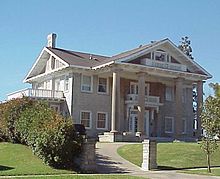
 Skelly Mansion, Maple Ridge
Maple Ridge & Sunset Terrace
The Maple Ridge Historic District is just south of downtown in Midtown. This neighborhood contains 'Black Gold Row', where the fabulous mansions built by the oil barons in the 1920s still stand, long after their original owners have gone.
Sunset Terrace is located adjacent to Maple Ridge on its South Side, Terwilleger Heights on its East Side and the Arkansas River to the West. It is traversed by the grand Woodward Boulevard, which links Maple Ridge to Brookside. Sunset Terrace contains many mansions built in the 1920' and 1930's.
 Large Craftsman, North Maple Ridge
Brookside
Brookside, like Cherry Street, is another popular shopping and entertainment district in Midtown. This area extends from the Arkansas River east to Lewis Avenue and south to 51st Street/Interstate 44. Its defining strip is South Peoria between 1st and 41st Streets, where visitors find a variety of shopping delights, beautiful Centennial Park and is home to more than 35 restaurants and nightspots (many with patio seating), featuring everything from sushi to old-fashioned burger and root beer stands. There are also plenty of swanky boutiques, decor shops, salons, and art galleries for window shopping. The atmosphere is chic and eclectic. Scenic Riverside Drive, which parallels the east bank of the river, and River Parks, the park that stretches along the riverbank, are also popular sections of Brookside.
Lortondale
This is a sub-division of modern homes along South Yale Avenue near 26th Street. Their low-pitch roofs and clean lines typify the style known as Mid-Century Modern. Construction began in 1953 and all Lortondale homes featured central heating and air conditioning- the first in the nation.
Ranch Acres
Recognized as a historic neighborhood, Ranch Acres was added the National Register of Historic Places in 2007. The neighborhood is an excellent example of a post-World War II ranch house subdivision. The area is situated primarily between 31st and 41st Streets along South Harvard.
Patrick Henry
The Patrick Henry neighborhood was developed during the Fifties and Sixties and situated between Harvard and Yale at 41st Street south I-44. Patrick Henry is made up of ranch-style homes known for their open floorplans and large lots. Many of these homes were featured on the annual Parade of Homes tours that featured new and modern designs.
Highland and Whiteside Park Area
This area is defined by the two neighborhood parks from which it takes its name. The homes in this area are mostly ranch-style homes. It area overlaps with the Patrick Henry neighborhood, extending East of Yale Avenue to Bishop Kelley High School. Mockingbird Lake is in this neighborhood, as is Tulsa campus of University of Oklahoma.
Kendall-Whittier
To the east of downtown is Tulsa’s oldest suburban shopping area and is noted for its abundance of red brick. The artsy, historic, and recently restored Circle Cinema is located in this area. The Kendall-Whittier shopping area and surrounding neighborhoods are now popular with Tulsa’s rapidly growing Hispanic community. Just east of this area is the University of Tulsa.
For a copy of the Kendall Whittier Neighborhood Masterplan developed by the neighborhood in partnership with the City of Tulsa please go to: http://www.cityoftulsa.org/Community/Revitalization/documents/KW%20Neighborhood%20Masterplan%2011142006.pdf
Swan Lake Historic District
Main article: Swan Lake (Tulsa)
Swan Lake is a historic district in Tulsa, Oklahoma. Its borders consist of 15th Street to the North, Utica Street to the East, 21st Street to the South, and Peoria Avenue to the west. This area was originally named Orcutt District for the landowner, and the lake was originally a cattle watering place. [6] It was the site of an amusement park in the early Twentieth Century, but is now notable for the number and architectural variety of houses and apartment buildings constructed in the 1920s and 1930s.
Terwilleger Heights
Terwilleger Heights is located immediately south and west of Utica Square bordered by 21st Street, 31st Street, Utica Avenue and Peoria Avenue. This area has early 1930s homes both grand and small, mature and many newly-planted trees, winding streets and is adjacent to the Philbrook Museum of Art and Woodward Park, site of the Tulsa Rose Garden.
North Tulsa
North Tulsa originally referred to the area north of the Frisco Railroad tracks up to the northern city limits. It was annexed by the city of Tulsa in 1904.[7] Farther east, the southern boundary was Admiral Boulevard. North Tulsa is home to a large percentage of Tulsa's African-American community. The area's Booker T. Washington High School, Tulsa’s African-American high school during the segregation era and now a magnet school, was recently judged to be the 58th best high school in the nation by Newsweek. Northeast of downtown, close to Tulsa International Airport, is Mohawk Park, which includes the Tulsa Zoo and the Oxley Nature Center, and the Tulsa Air and Space Museum. This area is also home to the American Airlines maintenance facility, one of Tulsa's largest employers.
Greenwood Historical District
Main article: Greenwood, Tulsa, Oklahoma
The Greenwood Historical District is just north of downtown and east of the Brady District. It was once one of the most affluent African-American communities in the United States and referred to as Black Wall Street. In 1921, thirty-five blocks of businesses and residences were burned in this district during the infamous Tulsa Race Riot, the bloodiest racial riot in the history of the United States. The Oklahoma Legislature passed laws in 2001 aimed at revitalizing Greenwood, setting up a scholarship fund for college-bound descendants of riot victims and appropriating $2 million for a riot memorial. As of 2004, two blocks of the old neighborhood have been restored and are part of the Greenwood Historical District. It is now home to the Greenwood Cultural Center, the Tulsa Race Riot Memorial, and the Oklahoma Jazz Hall of Fame, as well as Oklahoma State University - Tulsa and Langston University-Tulsa.
Brady Heights Historic District
Main article: Brady Heights (Tulsa)
 Brady mansion on North Denver Avenue
Brady Heights is a historic district in Tulsa, Oklahoma named for early resident, W. Tate Brady. Its boundaries are Marshall Street on the north, the alley between Cheyenne Avenue and Main Street on the east, Fairview Street on the south, and the Osage Expressway right-of-way on the west. From territorial days until the 1920s, Brady Heights was an important part of the then-fashionable north side of Tulsa. Young professional businessmen and oil men, like G. Y. Vandever, I. S. Mincks and “Diamond Joe” Wilson, owned homes there.
Owen Park
Main article:Owen Park, Tulsa, Oklahoma
The history of the Owen Park neighborhood can be traced to the early 19th Century. A description of the area was given by Washington Irving in his book, Tour of the Prairies. A monument in Tulsa's Owen Park denotes the point where the lands of the Osage, Creek and Cherokee nations met. The first American settler was Chauncey Owen, husband of a Creek woman who qualified for a land allotment. This land later became the Owen Park neighborhood. Its borders are Edison Avenue on the north, the municipal Owen Park on the east, the Keystone Expressway (Hwy 412) on the south, and Zenith Avenue on the west. Owen Park is a rapidly gentrifying historic neighborhood that has historic mansions and Crafstman style homes are very reasonable in price. It is one of the closest neighborhoods to the Brady District and downtown Tulsa.
Gilcrease Museum
Main article:Gilcrease Museum
Northwest of downtown on the Osage Indian Reservation is the Gilcrease Museum, considered by many to be the finest Western American and American Indian art collection in the world. Thomas Gilcrease was a member of the Creek nation who became very wealthy after the discovery of oil on his allotment. He invested much of his wealth in art, and opened a gallery on his estate in northwest Tulsa in 1949. He deeded the art collection, building and grounds to the City of Tulsa during the mid 1950s.
South Tulsa
South Tulsa is popularly considered to be south of 51st Street, bounded on the south by the city of Bixby, on the west by the Arkansas River and the city of Jenks, and on the east by the city of Broken Arrow. Many new luxurious homes have been constructed here in the last few decades, as well as numerous apartments, in various price ranges. Land in the area is becoming scarce, however, and development now has begun to spread to neighboring Jenks and Bixby to the south and west, as well as Broken Arrow to the east. As a more affluent demographic has moved into the area, businesses tailored to such residents have also opened nearby. The city's largest automotive dealer strip is located along S. Memorial Dr. from 91st to 101st Streets. The new Riverwalk Crossing Shopping Center, just over the river in Jenks at 96th st. includes a movie theater, fine dining, and shopping. Nearby lies the Oklahoma Aquarium, the only one in the state of Oklahoma. Local freshwater fish are complemented by a fine selection of saltwater animals, including sharks. Additionally the The Karl and Beverly White National Fishing Tackle Museum has over 20,000 pieces valued at more than $4 million. This exhibit makes up the largest and most comprehensive antique fishing tackle collection in the world.
St. Francis Hospital and its surrounding medical practitioner's offices is located at 61st and Yale and is one of the largest in the state. An another healthcare cluster exists around South 91st and Mingo, including SouthCrest Hospital, Cancer Treatment Center of America and Saint Francis Hospital South. Woodland Hills Mall, the largest in the state anchors the 71st street corridor. Numerous dining options are available in the area. Additionally, shopping centers surrounding the mall are panoramic in scope, as the options for shopping are seemingly endless. It is in this area that the 4-star John Q. Hammonds Renaissance Hotel is located, including conference and meeting rooms. It is located right off US 169, a major north-south highway in eastern south Tulsa. This road curves to the west at around 96th street and soon turns into the Creek Turnpike, a toll road that has been extended to the west to I-44 and to the east to I-44, nearly forming a semi-circular loop around southern Tulsa and its surrounding suburbs. The schools in the area are some of the state's largest, including Jenks and Union High School, with neighboring Broken Arrow being the largest. Tulsa Public School's Memorial High School is located here, along with prestigious, private Holland Hall. Jenks, and Union High Schools are annually among the best in the state and nation in football and their rivalry has drawn national attention. Tulsa Community College, the largest 2 year school in the state, has its Southeast campus off 81st and US 169. Parks in the area include LaFortune Park, with 2 public golf courses, playgrounds, swimming pool, and jogging trail, Hunters Park, with a disc golf course, jogging trail, playground, and fishing pond, and the Riverparks, which extend south to 101sts St.
Some of the largest and most influential churches in the country in Tulsa are in this part of Tulsa, including Victory Christian, Kirk of the Hills Presbyterian, Asbury United Methodist, South Tulsa Baptist and Grace Church.
Southeast Tulsa
Southeast Tulsa extends from the corner of South 31st street and Mingo Ave all the way East to South 41st street and 193rd East Ave (Lynn Lane). The area stretches South along Broken Arrow's Northwest city limits which extend to the corner of Tulsa's south 61st street and Mingo. Union Schools service these residents except for the homes being built farthest East, which Broken Arrow schools service. Neighborhood Parks, soccer fields, sports fields, and public pools can be found within the area. There are multiple corporate offices and other business in the area that staff large work forces. A large diversity of shopping and eating-out opportunities can be found in Southeast Tulsa. The area provides easy access to I 244, I 44, Hwy 169 (Mingo Valley Exp), The Creek Turnpike, and the Broken Arrow expressway. Such easy access makes it quick for driving to desired locations and businesses in Downtown Tulsa, Mid-town Tulsa, South Tulsa, West Tulsa, the Airport, all the major shopping/entertainment areas of the city, and to the outlying cities of Broken Arrow, Owasso, Bixby, and Jenks. The area offers housing built from the early 1970s to the present.
Southern Hills
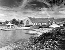 Clubhouse and pool at Southern Hills Country Club
Southern Hills is an exclusive neighborhood on the south side that is centered around the Southern Hills Country Club at 61st and Lewis. Southern Hills Country Club has hosted 13 major golf championships including four U.S. Opens. Many of the original homes in this neighborhood are sprawling suburban homes built in the ranch style.
The South Peoria district South of the Brookside Neighborhood, near 61st Street and Peoria Avenue. It has long been home to the largest percentage of Tulsa's African-Americans outside of North Tulsa.
East Tulsa
East Tulsa is a suburban-style area originating between Admiral and 21st Street and extending out to Mingo. Attractions in this part of the city include McClure Park, which is notable for its disc golf course, the Carl Smith Athletic Complex, and the popular Admiral Twin Drive-In movie theatre. There is also a large portion of Route 66 in East Tulsa. The parts of East Tulsa that fall in Union and Broken Arrow School districts are increasingly attracting high-income professionals looking for suburban life within the city limits. Mayo Demonstration Academy, a magnet school of the Tulsa Public School system, is located in this area. Eastgate Metroplex and East Central High School are also in this area. Also the area is home to Tulsa's hospitality district, where many hotels are located. Redbud Valley Nature Preserve is also located in this part of the city.
West Tulsa
Main article (West Tulsa, Tulsa, Oklahoma)
Communities of West Tulsa in city limits are Red Fork, Carbondale, Garden City, and Turkey Mountain. Other communities considered a part of West Tulsa but located in Creek County are Oakhurst, Oakridge, and Allen-Bowden.
West Tulsa is another reminder of Tulsa’s oil-rich past. Two oil refineries remain in operation to this day on the west bank of the river. This large industrial area gives way to wooded and hilly neighborhoods. The classic art deco Webster High School is here, as is the popular train-themed Ollie’s Station Restaurant, sitting next to the Tulsa rail yard. Other schools in West Tulsa include Berryhill High School, Remington Elementary, Robertson Elementary, Park Elementary and Clinton Middle School. Webster is the oldest existing high school facility in Tulsa, and has an active alumni association. Portions of Route 66 pass through West Tulsa. West Tulsa is broken up into several sections, including Carbondale and Red Fork, among others.
The Riverparks system, also here on the bank of the river, includes the Riverwest Festival Park, with its floating stage amphitheater overlooking downtown. Riverwest is home to such popular events as Tulsa's Oktoberfest, one of the largest of its kind in North America, and the Gatesway Balloon Festival.
West Tulsa is also home to The Oaks Country Club, one of Tulsa's three major country clubs, and Inverness Village, a large retirement community. In addition to these companies, Camp Loughridge, a Christian Summer Camp operates on 186 acres of land in West Tulsa.
References
- ^ Tulsa City-County Library, "Art Deco in Tulsa." Accessed August 22, 2011.[1]
- ^ This Land, "The Nightmare of Dreamland." Accessed September 12, 2011.[2]
- ^ Easterling, Mike. "East Village: Dead or Alive?." March 25, 2009. Accessed September 7, 2011.[3]
- ^ Krehbiel, Randy. Tulsa World. "3 Tulsa areas added to National Register." December 28, 2010. Retrieved November 21, 2011.
- ^ Tulsa Preservation Commission. "Ambassador Hotel." Retrieved November 19, 2011.[4]
- ^ Tulsa Preservation Commission. "Swan Lake Historic District." Retrieved November 20, 2011.[5]
- ^ Tulsa Preservation Commission Website. "Urban Development {1901 - 1945)." Accessed May 5, 2011.[6]
The City of Tulsa General Buildings · Climate · Education · Government · Famous Citizens · Geography · History · Mayors · Media · Transportation · Metropolitan AreaNeighborhoods 71st Street Corridor · Arkansas River · Brady Arts District · Blue Dome District · Brookside · Cherry Street · Downtown · East Tulsa · Greenwood · Midtown · North Tulsa · Red Fork · Southern Hills · Swan Lake · West Tulsa · Utica SquareLargest Suburbs Broken Arrow · Bartlesville · Sapulpa · Owasso · Sand Springs · Claremore · Bixby · Jenks · Glenpool · Coweta · Wagoner · Catoosa · CollinsvilleCategories:- Neighborhoods in Tulsa, Oklahoma


Wikimedia Foundation. 2010.