- Lop Nur
-
Lop Nur Chinese name Traditional Chinese 羅布泊 Simplified Chinese 罗布泊 Transcriptions Mandarin - Hanyu Pinyin Luóbù Pō - Wade–Giles Lo2-pu4 P'o1 Alternative Chinese name Traditional Chinese 羅布淖爾 Simplified Chinese 罗布淖尔 Transcriptions Mandarin - Hanyu Pinyin Luóbù Nào'ěr - Wade–Giles Lo2-pu4 Nao4-'erh3 Mongolian name Mongolian Lop Nuur Uyghur name Uyghur لوپنۇرLop Lake or Lop Nur (from the Mongolian[1]) is a group of small, now seasonal salt lake sand marshes between the Taklamakan and Kuruktag deserts in the Bayingolin Mongol Autonomous Prefecture, southeastern portion of Xinjiang Uygur Autonomous Region in the People's Republic of China.
The lake system into which the Tarim River and Shule River empty is the last remnant of the historical post-glacial Tarim Lake, which once covered more than 10,000 km2 (3,900 sq mi) in the Tarim Basin. Lop Nur is hydrologically endorheic—it is landbound and there is no outlet. Though it was determined to be a single salt lake by ancient Chinese geographers, the lake system has largely dried up from its 1928 measured area of 3,100 km2 (1,200 sq mi) and the desert has spread by windblown sandy loess. This has shifted the lake system 30 to 40 kilometres (19 to 25 mi) westwards during the past 40 years.[2] A partial cause for the destabilization of the desert has been the cutting of poplars and willows for firewood; in response, a reserve was established in 2003 to preserve 3,520 km2 (1,360 sq mi) of poplar.[3]
Contents
-

Basin of Lop Nur by satellite.
-

Satellite picture of the Basin of the former sea Lop Nur in the Desert of Lop.
-

Satellite image of a factory of Potassium chloride in Lop Nur.
History
 Map of Lop Nur by Folke Bergman, 1935.
From around 1800 BCE until the 9th century the lake supported a thriving Tocharian culture. Archaeologists have discovered the buried remains of settlements, as well as several of the Tarim mummies, along its ancient shoreline. Former water resources of the Tarim River and Lop Nur nurtured the kingdom of Loulan since the second century BCE, an ancient civilization along the Silk Road, which skirted the lake-filled basin. Loulan became a client-state of the Chinese empire in 55 BCE, renamed Shanshan. Marco Polo passed near the lake, and the famous explorers Ferdinand von Richthofen, Nikolai Przhevalsky, Sven Hedin and Aurel Stein visited and studied the area.[4] It is also likely that Swedish soldier Johan Gustaf Renate had visited the area when he was helping the Zunghars to produce maps over the area in the eighteenth century.[5]
On June 17, 1980, Chinese archeologist Peng Jiamu disappeared while walking into Lop Nur in search of water. His body was never found, and his disappearance continues to be one of the most mysterious events in the history of Chinese archeology. On June 13, 1996, the Chinese explorer Yu Chunshun died while trying to walk across Lop Nur.[6] Coordinates: 40°10′N 90°35′E / 40.167°N 90.583°E
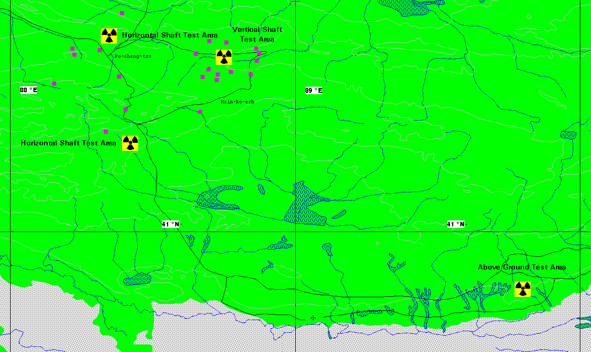
Lop Nur Nuclear Weapons Test Base
The first Chinese nuclear bomb test, codenamed "596", was tested at Lop Nur in 1964. The PRC detonated its first hydrogen bomb on June 17, 1967. Since 1964, the lake has been used as a nuclear test site. Until 1996, 45 nuclear tests were conducted.[7] The headquarters of the test base is at Malan, about 125 km (78 mi) northwest of Qinggir.[8]
Transportation
In 2006, a highway from Hami to Lop Nur (Xinjiang Provincial Hwy 235) was completed. [9]
In 2010, construction started on a 370 km (230 mi) railway along the same route, which will facilitate taking the potassium-rich salt mined at the lake to the Lanxin Railway mainline.[9]
Water System
The rivers that feed the Lop Nur marshes include the Tarim River, Kongque River, Qiemo River and Kaidu River.
Xiaohe Burial Site
 Europoid Mask, Lop Nur, China, 2000-1000 BCE
This bronze-age burial site is an oblong sand dune, from which more than thirty well preserved mummies, found in airtight ox-hide bags, have been excavated. The entire Xiaohe Tomb complex contains about 330 tombs, about 160 of which have been violated by grave robbers.[10] A local hunter guided the Swedish explorer and archeologist Folke Bergman to the site in 1934. An excavation project by the Xinjiang Cultural Relics and Archaeology Institute began in October, 2003. A total of 167 tombs have been dug up since the end of 2002 and excavations have revealed hundreds of smaller tombs built in layers, as well as other precious artifacts. In 2006, a valuable archeological finding was uncovered: a boat-shaped coffin wrapped in ox hide, containing the mummified face of a young woman, smiling.[11]
See also
Footnotes
- ^ Barber, Elizabeth (2000). The Mummies of Urümchi. W. W. Norton & Company. p. 125. "Two groups have laid claim to nor, the second half of Lop Nor. Nor is Mongol for "lake" and occurs as part of many lake names in Xinjiang and other parts of Central Asia, while nur is Uyghur for "bright" (as in the white of the salt flats). Mongol probably wins this one. But lop is opaque in both languages and in Chinese too, a fact suggesting that the name goes back to a time before Turks, Mongols, or Chinese had entered the territory."
- ^ "Desert Intrudes upon Tarim Lake". china.org.cn. http://www.china.org.cn/english/environment/114336.htm. Retrieved 2007-08-03.
- ^ "Tarim River Ecological Protection Suggested". china.org.cn. http://www.china.org.cn/english/2005/Mar/121947.htm. Retrieved 2007-08-03.
- ^ "The Wandering Lake". nasa.gov. http://earthobservatory.nasa.gov/Newsroom/NewImages/images.php3?img_id=6762. Retrieved 2007-08-03.
- ^ August Strindberg, "En svensk karta över Lop-nor och Tarimbäckenet" (in Swedish)
- ^ "Found Dead - Yu Chunshun, 48, Intrepid Chinese explorer". asiaweek.com. http://www.asiaweek.com/asiaweek/96/0705/feat12.html. Retrieved 2007-09-18.
- ^ "Chinese Nuclear Tests Allegedly Cause 750,000 Deaths" Epoch Times. March 30, 2009. [1]
- ^ "Lop Nor Nuclear Weapons Test Base". nti. http://www.nti.org/db/china/lopnur.htm. Retrieved 2007-08-03.
- ^ a b China starts building railway into "sea of death", GOV.cn, Thursday, March 4, 2010
- ^ "Burial Site from the Bronze Age, Lop Nur, Xinjiang.". www.china.org.cn. http://www.china.org.cn/english/features/Archaeology/149496.htm#2. Retrieved 2007-09-18.
- ^ "Silk Road Documentary Unearths Latest Findings". china.org.cn. http://www.china.org.cn/english/features/Archaeology/162045.htm. Retrieved 2007-09-18.
External links
- Map of the Lop Nur nuclear test facility
- Lop Nor Nuclear Weapons Test Base
- Satellite imagery of the Lop Nur nuclear test facility
- Lop Desert
- Surveying the Lop Nor
- Salt Fields in Former “Wandering” Lake Lop Nur, China - May 13th, 2009 - Earth Snapshot
- Downloadable article: "Evidence that a West-East admixed population lived in the Tarim Basin as early as the early Bronze Age" Li et al. BMC Biology 2010, 8:15. [2]
Lakes of China Famous Freshwater Lakes Xingkai Lake • Poyang Lake • Lake Dongting • Lake Tai • Hulun Lake • Lake Hongze • Nansi Lake • Bosten Lake • Lake Chao • Gaoyou Lake • Ngoring Lake • Gyaring Lake • Lake Sayram • Baiyangdian Lake • Hong Lake • Longgan Lake • Liangzi Lake • Dian Lake • Ulansuhai Nur • Luoma Lake • Erhai Lake • Junshan Lake • Fuxian Lake • Shijiu Lake • Wabu Lake • Nanyi Lake • Dongping Lake • Ge Lake • Yangcheng Lake • Chenghai Lake • Dianshan Lake • Yangzong Lake • Xingyun Lake • Qilu Lake • Yilong Lake • Ayding Lake • Buir Lake • Chagan Lake (China) • Daming Lake • Diexi Lake • Dongqian Lake • Heaven Lake • Hundred Flower Pond • Karakul (China) • Kunming Lake • Lugu Lake • Ruyi Lake • South Lake (Jiaxing) • Tangjiashan Lake • White Cloud Lake • Xuanwu Lake • Yueya Lake (Nanjing)
Famous Salt Lakes Qinghai Lake • Namtso • Serling Lake • Zhari Namco • Tangra Yumco • Ulungur Lake • Yamdrok Lake • Pangong Tso • Lake Rakshastal • Aibi Lake • Ayding LakeNational Park Jingpo Lake • Wudalianchi Lake • Lake Tai • West Lake • East Lake (Wuhan) • Tianchi Lake (Tianshan) • Songhua Lake • Jingyue Lake • Slim West Lake • Lake Dongting • Hongfeng Lake • Lake Dian • Lake Jin (Taining) • Crescent Lake (Dunhuang) • Qinghai Lake • Lake Chao • Fairy Lake • West Lake (Huizhou) • Lake Qiong • Bosten Lake • Feiyun Lake • Huguang Rock • Bailong Lake • Lake Sayram • Huating Lake • Zhelin LakeProtected Wetlands Dongting Lake • Poyang Lake • Dalai Nur • South Dongting Lake • West Dongting Lake • Xingkai Lake • Bita Lake • Lake Napa • Lashi Lake • Ngoring Lake • Gyaring Lake • Manasarovar LakeNature Reserve Hengshui Lake • Xingkai Lake • Wudalianchi Lake • Shengjin Lake • Lake Poyang • Dongting Lake • Erhai Lake • Serling Lake • West Lake (Dunhuang) • Gahai Lake • Qinghai Lake • Caohai Lake • Dalai Nur • Kanas Lake • Lake Hongze • Haba LakeReservoirs Three Gorges Dam • Longtan Dam • Longyangxia Dam • Danjiangkou Dam • Sapung Lake • Qiandao Lake • Xinfengjiang Reservoir • Liujiaxia Reservoir • Changshou Lake • Yantan Dam • Jiangkou Reservoir • See also: List of dams and reservoirs in ChinaCategories:- Lakes of China
- Endorheic lakes of Asia
- Nuclear test sites
- Chinese nuclear test sites
- Sites along the Silk Road
- Shrunken lakes
- Lakes of Xinjiang
-


Wikimedia Foundation. 2010.