- Charlbury
-
Coordinates: 51°52′19″N 1°28′55″W / 51.872°N 1.482°W
Charlbury 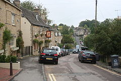
 Charlbury
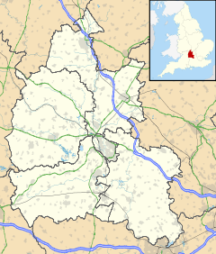
Charlbury shown within OxfordshirePopulation 2,984 (2001 census)[1] OS grid reference SP3519 District West Oxfordshire Shire county Oxfordshire Region South East Country England Sovereign state United Kingdom Post town Chipping Norton Postcode district OX7 Dialling code 01608 Police Thames Valley Fire Oxfordshire Ambulance South Central EU Parliament South East England UK Parliament Witney Website Charlbury Town Council List of places: UK • England • Oxfordshire Charlbury (
 /ˈtʃɑrlbᵊri/ or /ˈtʃɔrlbᵊri/, locally /ˈtʃɔwbri/) is a small town and civil parish in the Evenlode valley, about 6 miles (9.7 km) north of Witney in West Oxfordshire. It is on the edge of the Wychwood forest and the Cotswolds.
Contents
Place name
The origin of the town's toponym is obscure. At first sight it may appear to relate to the name 'Charles' but some[2] hold it to derive from the Old English word ceorl (probably pronounced /tʃɔrl/) meaning "freeman of the lowest class", whence the Modern English words "churl" and "churlish" (which are now used only in a derogatory sense), whilst other sources state it to derive from the Old English personal name Ceorl.[3] For this reason some hold the latter two pronunciations more valid than the former, and the current spelling incorrect, preferring 'Chorlbury'. Both the name 'Charles'/Ceorl and the word ceorl/'churl' derive from the same Proto-Germanic word *karlaz.[4]
Notable buildings
On the outskirts of Charlbury is Lee Place, the former Dower house of Ditchley[5] and now the home of the Duchess of Marlborough.[citation needed] Cornbury Park, now owned by Lord Rotherwick, contains a 17th century country house designed partly by the architect Hugh May.[6]
Parish church
The Church of England parish church of St. Mary the Virgin is by tradition associated with Saint Diuma,[7] the 7th century first Bishop of Mercia. By 1197 or 1198 the church belonged to Eynsham Abbey, which held the advowson of the parish until the dissolution of the monasteries in the 16th century.[8] The arcade of Norman arches between the nave and north aisle dates from this period. In the 13th century the building was greatly enlarged: the chancel was extended eastwards and the south aisle, west tower and north and south chapels were added.[8] In the 14th century the present east windows of the chancel and south chapel were added, both in the Decorated Gothic style.[8] During or before the 15th century the north aisle was widened. In the 15th century additions were made to the building in the Perpendicular Gothic style: the tower was extended higher and a west door was inserted in its base, a clerestorey was added to the nave and new windows were inserted in both aisles.[8] In the 16th century the Perpendicular style south porch was added. Two wooden galleries were added, possibly in the 18th century. In the 18th or early in the 19th century most of the windows lost their tracery.[8]
In 1856 the Gothic Revival architect G.E. Street removed the galleries and refitted the church with new pews, and in 1874 another Gothic Revival architect, Charles Buckeridge, rebuilt the chancel.[8] In the early 1990s an extensive reordering saw the pews removed and the main altar moved to the west end.
The organ is a two-manual Wyvern digital instrument, installed in 2010 to replace a Makin digital in place since 1990.[citation needed] The bell tower has a ring of six bells, all cast in 1716[9] by Abraham I Rudhall of Gloucester[10] plus a Sanctus bell cast by an unknown founder in about 1599.[9]
Transport
Charlbury railway station is on the Cotswold Line. It is served by First Great Western trains between London, Oxford, Great Malvern, Worcester and Hereford.
Bus services include a branch of Stagecoach in Oxfordshire route S3 between Charlbury and Oxford via Woodstock. Services on the Charlbury branch of route S3 run hourly, Monday - Saturday. Route S3 evening and Sunday services do not serve Charlbury.[11] RH Buses' route X9 between Chipping Norton and Witney runs hourly via Charlbury, Monday - Saturday.[12] There are other local bus services to and from Charlbury that run less than hourly.[13]
Amenities
Charlbury Town Football Club plays in Witney and District Football League Premier Division.[14] Charlbury Cricket Club[15] plays in Oxfordshire Cricket Association League Division 1.[16] Charlbury has a Women's Institute.[17]
Charlbury Museum, opened in 1962, is a local museum run by the Charlbury Society.
Charlbury hosts a number of public events each year: the Riverside Music Festival in June, the Cornbury Music Festival and Charlbury Beer Festival in July and the Charlbury Street Fair, which dates back to 1955, in September.[citation needed]
 View looking down Dyers Hill.
Politics
Charlbury is in the parliamentary constituency of Conservative leader and Prime Minister David Cameron. Charlbury's county councillor, Neil Owen, is a Conservative and two district councillors, Glena Chadwick and Michael Breakell are both Liberal Democrats.
See also
References
- ^ "Area: Charlbury CP (Parish): Parish Headcounts". Neighbourhood Statistics. Office for National Statistics. http://www.neighbourhood.statistics.gov.uk/dissemination/LeadTableView.do?a=7&b=798791&c=Charlbury&d=16&g=481595&i=1001x1003x1006&k=headcounts&o=1&m=0&r=1&s=1269379785140&enc=1&domainId=15&dsFamilyId=779. Retrieved 23 March 2010.
- ^ Corbett, 1962, page 14
- ^ Mills & Room, 2003, page not cited
- ^ Online Etymological Dictionary
- ^ Sherwood & Pevsner, 1974, page 528
- ^ Sherwood & Pevsner, 1974, pages 553-555
- ^ Corbett, 1962, page 20
- ^ a b c d e f Crossley et al., 1972, pages 127-157
- ^ a b "Charlbury S Mary V". Dove's Guide for Church Bell Ringers. http://dove.cccbr.org.uk/detail.php?searchString=Charlbury&DoveID=CHARLBURY. Retrieved 1 February 2011.
- ^ "Bell Founders". Dove's Guide for Church Bell Ringers. http://dove.cccbr.org.uk/founders.php. Retrieved 1 February 2011.
- ^ Stagecoach in Oxfordshire, route S3
- ^ RH Buses, route X9
- ^ Oxfordshire County Council (December 2008). Oxfordshire Public Transport Guide. Oxfordshire County Council.
- ^ Witney & District Football League
- ^ Charlbury Cricket Club
- ^ Oxfordshire Cricket Association
- ^ Oxfordshire Federation of Women's Institutes
Sources
- Corbett, E (1962). A History of Spelsbury. Banbury: Cheney and Sons.
- Crossley, Alan (ed.); Colvin, Christina; Cooper, Janet; Cooper, N.H.; Harvey, P.D.A.; Hollings, Marjory; Hook, Judith; Jessup, Mary et al. (1972). A History of the County of Oxford, Volume 10. Victoria County History. pp. 127–157.
- Mills, A.D.; Room, A. (2003). A Dictionary of British Place-Names. Oxford: Oxford University Press. ISBN 0198527586.
- Sherwood, Jennifer; Pevsner, Nikolaus (1974). Oxfordshire. The Buildings of England. Harmondsworth: Penguin Books. pp. 527–529. ISBN 0 14 071045 0.
External links
Oxfordshire • County Council elections • District Council elections • Witney County Constituency Towns Burford (Signet, Upton) • Carterton • Charlbury • Chipping Norton (Southcombe) • Witney (Cogges, Madley Park) • Woodstock (Hensington, Old Woodstock)
Large Villages Aston, Cote, Shifford and Chimney (Aston, Cote, Shifford, Chimney) • Bampton (Lower Haddon, Weald) • Brize Norton • Ducklington • Enstone (Church Enstone, Neat Enstone, Chalford, Cleveley, Fulwell, Gagingwell, Lidstone, Radford) • Eynsham (Barnard Gate) • Freeland • Hailey (New Yatt) • Hanborough (Church Hanborough, Long Hanborough) • Milton-under-Wychwood • Minster Lovell • North Leigh (East End, Wilcote) • Shipton-under-Wychwood • Standlake (Brighthampton) • Steeple Barton (Middle Barton) • StonesfieldOther Civil
Parishes
(Component
Villages
and Hamlets)Alvescot • Ascott-under-Wychwood (Ascott d'Oyley, Ascott Earl) • Asthall (Asthall Leigh, Worsham) • Black Bourton • Bladon • Blenheim • Broadwell • Bruern • Cassington (Worton) • Chadlington • Chastleton • Chilson (Shorthampton) • Churchill • Clanfield • Combe • Cornbury and Wychwood (Cornbury, Wychwood) • Cornwell • Crawley • Curbridge • Fawler • Fifield • Filkins and Broughton Poggs (Filkins, Broughton Poggs) • Finstock • Fulbrook • Glympton • Grafton and Radcot (Grafton, Radcot) • Great Tew • Hardwick-with-Yelford (Hardwick, Yelford) • Heythrop (Dunthrop) • Holwell • Idbury (Bould, Foscot) • Kelmscott • Kencot • Kiddington with Asterleigh (Asterleigh, Kiddington, Over Kiddington) • Kingham • Langford • Leafield • Lew • Little Faringdon • Little Tew • Lyneham • Northmoor • Over Norton • Ramsden (Mount Skippett) • Rollright (Great Rollright, Little Rollright) • Rousham • Salford • Sandford St. Martin (Ledwell) • Sarsden • Shilton • South Leigh • Spelsbury (Dean, Taston) • Stanton Harcourt • Swerford • Swinbrook and Widford (Swinbrook, Widford) • Tackley • Taynton • Westcott Barton • Westwell • Wootton (Dornford, Hordley) • Worton (Nether Worton, Over Worton)Former Districts
and BoroughsChipping Norton Rural District • Municipal Borough of Chipping Norton • Witney Urban District • Witney Rural District • Municipal Borough of Woodstock • Woodstock Rural DistrictFormer
ConstituenciesList of Parliamentary constituencies in Oxfordshire • List of places in Oxfordshire • List of civil parishes in Oxfordshire Ceremonial county of Oxfordshire Oxfordshire Portal Boroughs or districts Major settlements Abingdon • Banbury • Bicester • Burford • Carterton • Charlbury • Chipping Norton • Didcot • Faringdon • Henley-on-Thames • Oxford • Thame • Wallingford • Wantage • Watlington • Witney • Woodstock
See also: List of civil parishes in OxfordshireTopics Categories:- Towns in Oxfordshire
- Civil parishes in Oxfordshire
- West Oxfordshire


Wikimedia Foundation. 2010.