- Coalcliff, New South Wales
-
Coalcliff
Wollongong, New South Wales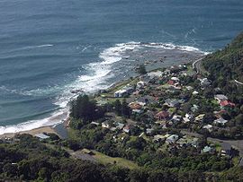
View of Coalcliff from the Illawarra EscarpmentPopulation: 179[1] Postcode: 2508 Coordinates: 34°14′S 150°58′E / 34.233°S 150.967°ECoordinates: 34°14′S 150°58′E / 34.233°S 150.967°E[2] LGA: City of Wollongong State District: Heathcote Federal Division: Cunningham Suburbs around Coalcliff: Stanwell Park Coalcliff Clifton 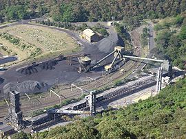 The Illawarra Coke Company (ICC) in Coalcliff.
Coalcliff is a town on the coast of New South Wales, Australia, between Sydney and Wollongong. Together with Stanwell Park it belongs to the Little Bulli indentation of the northern Illawarra coast strip.
Contents
History
In 1796 William Clark and others trekking north to Port Jackson from the wrecked ship Sydney Cove noticed coal exposed at the cliffs there and made a fire from it, attracting rescuers, giving the area its name.[3] George Bass was despatched to report on it and traced the deposit along the shore and inland.[4] There was nowhere for ships to safely land though, so it was not until 1850 that it began to be excavated.
Attractions
The Sea Cliff Bridge surrounding the Coal Cliffs was opened on 11 December 2005 and offers a spectacular sidewalk above the ocean and along the escarpment. There are splendid views offered towards Wollongong and Port Kembla in the south such as towards Bald Hill and the Royal National Park in the north.
Activities
Coalcliff hosts its own Surf Life Saving Club with events like Nippers in summertime and assuring beach safety. The Sea Eals winter swimming club takes place in the rock pool and is co-organized together with the Helensburgh-Stanwell Park Surf Life Saving Club such as the yearly 2.4 km Ocean Challenge swim between the two clubs in early April.
Industry
Coalcliff hosts the Illawarra Coke Company (ICC) as one of the two main sites. The Cokeworks here and at Corrimal produce approximately 250,000 tonnes of coke per annum using non-recovery technology. Since over 90 years coke has been produced here.
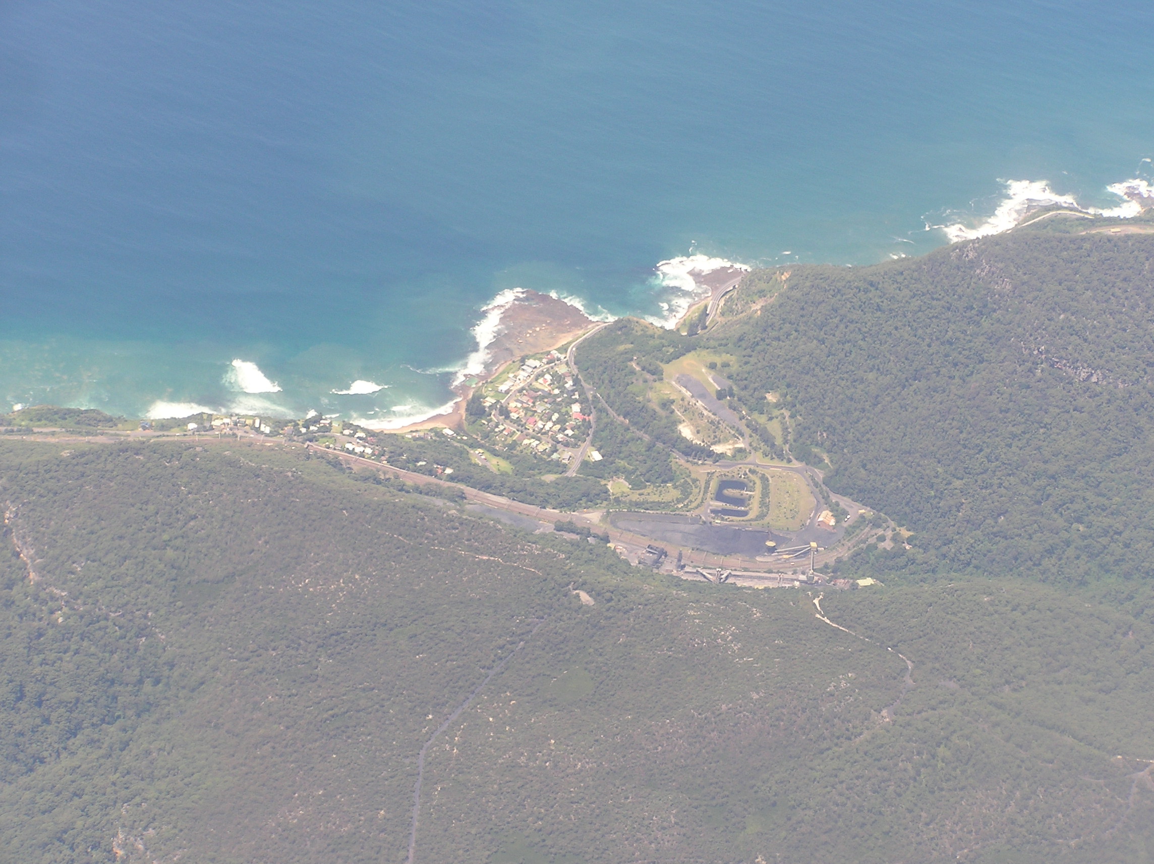
 Aerial photo from north west
References
- ^ Australian Bureau of Statistics (25 October 2007). "Coalcliff (State Suburb)". 2006 Census QuickStats. http://www.censusdata.abs.gov.au/ABSNavigation/prenav/LocationSearch?collection=Census&period=2006&areacode=SSC16731&producttype=QuickStats&breadcrumb=PL&action=401. Retrieved 2009-01-11.
- ^ Coalcliff page at Geoscience Australia
- ^ "PLACE NAMES.". The Australian Women's Weekly (1932-1982) (1932-1982: National Library of Australia): p. 61. 13 May 1964. http://nla.gov.au/nla.news-article55185386. Retrieved 22 February 2011.
- ^ Miriam Estensen, The Life of George Bass, Allen and Unwin, 2005, ISBN 1-74114-130-3, page 72
External links
- "Illawarra Coal" - An unofficial history of coal mining in the Illawarra
- Coalcliff Surf Life Saving Club
- Coalcliff Community Web Portal
- Illawarra Coke Company - web site
Suburbs and Localities of Wollongong, New South Wales Albion Park · Albion Park Rail · Austinmer · Avon · Avondale · Balarang · Balgownie · Barrack Heights · Barrack Point · Bellambi · Berkeley · Blackbutt · Bombo · Broughton Village · Brownsville · Bulli · Burning Palms · Calderwood · Carrington Falls · Cleveland · Clifton · Coalcliff · Coledale · Coniston · Cordeaux · Cordeaux Heights · Corrimal · Cringila · Croom · Curramore · Dapto · Darkes Forest · Dombarton · Dunmore · East Corrimal · Fairy Meadow · Farmborough Heights · Fernhill · Figtree · Flinders · Foxground · Gerringong · Gerroa · Gwynneville · Haywards Bay · Helensburgh · Horsley · Huntley · Jamberoo · Jerrara · Kanahooka · Keiraville · Kembla Grange · Kembla Heights · Kemblawarra · Kiama · Kiama Downs · Kiama Heights · Knights Hill · Koonawarra · Lake Heights · Lake Illawarra · Lilyvale · Macquarie Pass · Maddens Plains · Mangerton · Marshall Mount · Minnamurra · Mount Keira · Mount Kembla · Mount Ousley · Mount Pleasant · Mount Saint Thomas · Mount Warrigal · North Macquarie · North Wollongong · Oak Flats · Otford · Penrose · Port Kembla · Primbee · Rose Valley · Russell Vale · Saddleback Mountain · Scarborough · Shell Cove · Shellharbour · Shellharbour City Centre · Spring Hill · Stanwell Park · Stanwell Tops · Tarrawanna · Thirroul · Tongarra · Toolijooa · Towradgi · Tullimbar · Unanderra · Upper Kangaroo Valley · Warilla · Warrawong · Werri Beach · West Wollongong · Willow Vale · Windang · Wollongong · Wombarra · Wongawilli · Woonona · Yallah · Yellow Rock
Categories:- Suburbs of Wollongong, New South Wales
- Surf lifesaving
- Mining towns in New South Wales


Wikimedia Foundation. 2010.