- Paschim Medinipur district
-
Paschim Medinipur district
পশ্চিম মেদিনীপুর জেলা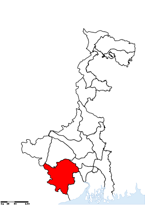
Location of Paschim Medinipur district in West BengalState West Bengal,  India
IndiaAdministrative division Burdwan Headquarters Midnapore Area 9,345 km2 (3,608 sq mi) Population 59,43,300 (2011) Population density 636 /km2 (1,650 /sq mi) Urban population 11.9 per cent Literacy 79.04 per cent Sex ratio 960 Lok Sabha Constituencies Medinipur, Ghatal, Jhargram (ST) - all have assembly segments in adjoining districts, Arambagh - with one assembly segmant in the district Assembly Seats Dantan, Nayagram, Gopiballavpur, Jhargram, Keshiary, Kharagpur Sadar, Narayangarh, Sabang, Pingla, Kharagpur, Debra, Daspur, Ghatal, Chandrakona, Garbeta, Salboni, Keshpur, Medinipur, Binpur Major highways NH 6, NH 60 Average annual precipitation 2,111 mm Official website For other uses, see Midnapore (disambiguation). Map of Paschim Medinipur district showing Midnapore
Paschim Medinipur district or West Midnapore district (Bengali: পশ্চিম মেদিনীপুর জেলা) (also known as Midnapore West) is the districts of the state of West Bengal, India. It was formed on January 1, 2002 after the Partition of Midnapore into Paschim Medinipur and Purba Medinipur. The district has 4 sub-divisions: Kharagpur, Medinipur Sadar, Ghatal and Jhargram. It is currently a part of the Red Corridor.[1]
Contents
Geography
Major cities and towns
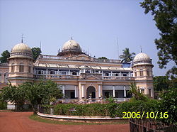 Jhargram palace at Jhargram
Midnapore is the district headquarters. Other important towns and cities in the district include: Kharagpur, Jhargram, Ghatal, Belda, Chandrakona, Garbeta,Balichak, Dantan, Mohanpur, Gopiballavpur, Nayagram, Keshiari, Keshpur, Narayangarh, Sabang, Daspur,
Economy
In 2006 the Ministry of Panchayati Raj named Paschim Medinipur one of the country's 250 most backward districts (out of a total of 640).[2] It is one of the eleven districts in West Bengal currently receiving funds from the Backward Regions Grant Fund Programme (BRGF).[2]
Divisions
Administrative subdivisions
The district comprises four subdivisions: Kharagpur, Medinipur Sadar, Ghatal and Jhargram. Kharagpur subdivision consists of Kharagpur municipality and ten community development blocks: Dantan–I, Dantan–II, Pingla, Kharagpur–I, Kharagpur–II, Sabang, Mohanpur, Narayangarh, Keshiari and Debra. Medinipur Sadar subdivision consists of Midnapore municipality and six community development blocks: Medinipur Sadar, Garhbeta–I, Garhbeta–II, Garhbeta–III, Keshpur and Shalboni. Ghatal subdivision consists of five municipalities (Ramjibanpur, Chandrakona, Kshirpai, Kharar and Ghatal) and five community development blocks: Chandrakona–I, Chandrakona–II, Daspur–I, Daspur–II and Ghatal. Jhargram subdivision consists of Jhargram municipality and eight community development blocks: Binpur–I, Binpur–II, Jamboni, Jhargram, Gopiballavpur–I, Gopiballavpur–II, Nayagram and Sankrail.[3]
Midnapore is the district headquarters. There are 21 police stations, 30 development blocks, 5 municipalities and 290 gram panchayats in this district.[3][4]
Other than municipality area, each subdivision contains community development blocks which in turn are divided into rural areas and census towns. In total there are 12 urban units: 8 municipalities and 4 census towns.[4]
Kharagpur subdivision
- One municipality: Kharagpur.
- Dantan–I community development block consists of rural areas only with 9 gram panchayats.
- Dantan–II community development block consists of rural areas only with 7 gram panchayats.
- Pingla community development block consists of rural areas only with 10 gram panchayats.
- Kharagpur–I community development block consists of rural areas with 7 gram panchayats and one census town: Kharagpur Railway Settlement.
- Kharagpur–II community development block consists of rural areas only with 9 gram panchayats.
- Sabang community development block consists of rural areas only with 13 gram panchayats.
- Mohanpur community development block consists of rural areas only with 5 gram panchayats.
- Narayangarh community development block consists of rural areas only with 16 gram panchayats.
- Keshiari community development block consists of rural areas with 9 gram panchayats and one census town: Deuli.
- Debra community development block consists of rural areas with 14 gram panchayats and one census town: Balichak.
Medinipur Sadar subdivision
- One municipality: Midnapore.
- Medinipur Sadar community development block consists of rural areas only with 9 gram panchayats.
- Garhbeta–I community development block consists of rural areas only with 12 gram panchayats.
- Garhbeta–II community development block consists of rural areas only with 10 gram panchayats.
- Garhbeta–III community development block consists of rural areas with 8 gram panchayats and one census town: Durllabhganj.
- Keshpur community development block consists of rural areas only with 15 gram panchayats.
- Shalboni community development block consists of rural areas only with 10 gram panchayats.
Ghatal subdivision
- Five municipalities: Ramjibanpur, Chandrakona, Khirpai, Kharar and Ghatal.
- Chandrakona–I community development block consists of rural areas only with 6 gram panchayats.
- Chandrakona–II community development block consists of rural areas only with 6 gram panchayats.
- Daspur–I community development block consists of rural areas only with 10 gram panchayats.
- Daspur–II community development block consists of rural areas only with 14 gram panchayats.
- Ghatal community development block consists of rural areas only with 12 gram panchayats.
Jhargram subdivision
- One municipality: Jhargram.
- Binpur–I community development block consists of rural areas only with 10 gram panchayats.
- Binpur–II community development block consists of rural areas only with 10 gram panchayats.
- Jamboni community development block consists of rural areas only with 10 gram panchayats.
- Jhargram community development block consists of rural areas only with 13 gram panchayats.
- Gopiballavpur–I community development block consists of rural areas only with 7 gram panchayats.
- Gopiballavpur–II community development block consists of rural areas only with 7 gram panchayats.
- Nayagram community development block consists of rural areas only with 12 gram panchayats.
- Sankrail community development block consists of rural areas only with 10 gram panchayats.
Demographics
According to the 2011 census Paschim Medinipur district has a population of 5,943,300 ,[5] roughly equal to the nation of Eritrea[6] or the US state of Missouri.[7] This gives it a ranking of 14th in India (out of a total of 640).[5] The district has a population density of 636 inhabitants per square kilometre (1,650 /sq mi) .[5] Its population growth rate over the decade 2001-2011 was 14.44 %.[5] Paschim Medinipur has a sex ratio of 960 females for every 1000 males,[5] and a literacy rate of 79.04 %.[5]
Culture
Tourism
- Chilkigarh (Kanak Durga Temple and park)
- Belpahari
- Jhargram
- Gopegarh Heritage Park
- Hatibari forest banglow and jhilli pakhiralay
- kankrajhore
- Garrasini asharam,near Belpahari
- Kaniashar pahar,near Belpahari
- Gurguripal Heritage Park
- Parimalkanan park,c.k.t
- Gangani [Garhbeta]
- Rameshwar Temple,near Rohini(On the bank of Subarnarekha river with nearby green forest called TAPOBAN)
- Gourya Temple, Near Kharagpur
- ECO Park DURGAHURI, Near SANKRAIL
- Bisnu Temple, kultikri
Notable personalities
- Sahid Kshudiram Basu (Mouboni, Keshpur PS)
- Iswar Chandra Vidyasagar (Birsingha, Ghatal PS)
- Byomkes Chakrabarti (Gopinathpur,Kharar, Ghatal PS & Kapgari, Jhargram PS)
- Swadeshi Movement (Aloke kendra.Marahtala,ps Debra Paschimmedinipore.W.B)
Education
Universities and Colleges
- Vidyasagar University[8]
- Midnapore Medical College & Hospital[9]
- Indian Institute of Technology, Kharagpur[10]
- Midnapore College[11]
- Kharagpur College
- Midnapore Engineering & Management College, shortly opening
- Subarnarekha Mahavidyalaya, Gopiballavpur
- Midnapore Law College[12]
- Institute of Science and Technology, Chandrakona Town[13]
- Raja Narendralal Khan Mahila Mahavidyalaya
- Hijli College
- Jhargram Raj College[14]
- Seva-Bharati Mahavidyalaya, Kapgari
- Seva-Bharati Krishi Kendra [15]
- Kharagpur Homeopathic Medical College and Hospital,Kaushallya
- Midnapore Homoeopathic Medical College and Hospital
- Anil Bishwas Smriti Mahavidyalaya,Kultikiri
- Bhattar College,Dantan[16]
- Belda College[17]
- Kaibalyadayini Banijya Mahavidyalaya
- Keshpur College
- Garhbeta college[18]
- Palpara College
- Sabang college
- pingla college
- Moyna college
- Ghatal Rabindrasatabarsiki Mahavidyalaya
- Chandrakona Vidyasagar Mahavidyalaya
- keshiary politechnic college
- vivekananda satabarsiki mahavidyalaya,Manikpara
- BHATTAR COLLEGE, DANTAN
NGOs
- Sarada Kalyan Bhandar[19]
- Vidyasagar Vidyapith
- Sri Sri Nitya Gopal Vision Care Foundation
- Midnapore.in - Legacy of Midnapore
- C.F.Andrews .Memorial.Society-Jhargram
References
- ^ "83 districts under the Security Related Expenditure Scheme". IntelliBriefs. 2009-12-11. http://intellibriefs.blogspot.com/2009/12/naxal-menace-83-districts-under.html. Retrieved 2011-09-17.
- ^ a b Ministry of Panchayati Raj (September 8, 2009). "A Note on the Backward Regions Grant Fund Programme". National Institute of Rural Development. http://www.nird.org.in/brgf/doc/brgf_BackgroundNote.pdf. Retrieved September 27, 2011.
- ^ a b "Directory of District, Sub division, Panchayat Samiti/ Block and Gram Panchayats in West Bengal, March 2008". West Bengal. National Informatics Centre, India. 2008-03-19. http://wbdemo5.nic.in/writereaddata/Directoryof_District_Block_GPs(RevisedMarch-2008).doc. Retrieved 2008-12-06.
- ^ a b "Administration Setup". Official website of Purba Medinipur district. http://purbamedinipur.gov.in/ADMIN.htm. Retrieved 2008-12-06.[dead link]
- ^ a b c d e f "District Census 2011". Census2011.co.in. 2011. http://www.census2011.co.in/district.php. Retrieved 2011-09-30.
- ^ US Directorate of Intelligence. "Country Comparison:Population". https://www.cia.gov/library/publications/the-world-factbook/rankorder/2119rank.html. Retrieved 2011-10-01. "Eritrea 5,939,484 July 2011 est."
- ^ "2010 Resident Population Data". U. S. Census Bureau. http://2010.census.gov/2010census/data/apportionment-pop-text.php. Retrieved 2011-09-30. "Missouri 5,988,927"
- ^ [1]
- ^ http://www.midnaporemch.org/
- ^ [2]
- ^ [3]
- ^ http://www.midnaporelawcollege.org/
- ^ [4]
- ^ http://jhargramrajcollege.org/
- ^ Seva-Bharati
- ^ http://bhattercollege.org.in/
- ^ http://www.beldacollege.org/
- ^ [5]
- ^ [6]
External links
- Official website of Paschim Midnapore
- Legacy of Midnapore (Medinipur,Midnapur,Purba Medinipur, Paschim Medinipur,East Midnapore,West Midnapore)
- News of district bifurcation
- Map of old Medinipur district (district has now been split)
- Jhargram Tourism

Bankura district Hooghly district East Singhbhum district, Jharkhand 
Howrah district  Paschim Medinipur district

Mayurbhanj district, Orissa Balasore district, Orissa East Midnapore district Cities and towns in Paschim Medinipur District Kharagpur subdivision Medinipur Sadar subdivision Ghatal subdivision Jhargram subdivision Related topics Paschim Medinipur topics · People fom Paschim Medinipur district · Villages in Paschim Medinipur districtCities and towns
in other districtsBankura · Bardhaman · Birbhum · Cooch Behar · Dakshin Dinajpur · Darjeeling · Hooghly · Howrah · Jalpaiguri · Malda · Murshidabad · Nadia · North 24 Parganas · Purba Medinipur · Purulia · South 24 Parganas · Uttar DinajpurDivisions & Districts of West Bengal Burdwan division Jalpaiguri division Presidency division Paschim Medinipur district topics General Bargi • Chhoto Angaria massacre • Dharmathakur • Dudhkundi Airfield • Gajan • Hijli Detention Camp • Indian Institute of Technology Kharagpur • Kalaikunda Air Force Station • Kurumbera Fort • Nehru Museum of Science and Technology • Operation Lalgarh • Partition of Midnapore • Vidyasagar UniversityPeople Subdivisions Territories Locations
other than cities and townsLalgarh • RohiniMunicipalities Community development blocks Medinipur Sadar subdivision Midnapore Sadar • Garhbeta I • Garhbeta II • Garhbeta III • Keshpur • Salboni Jhargram subdivision Binpur I • Binpur II • Jamboni • Jhargram • Gopiballavpur I • Gopiballavpur II • Nayagram • Sankrail Ghatal subdivision Chandrakona I • Chandrakona II • Daspur I • Daspur II • Ghatal Kharagpur subdivision Dantan I • Dantan II • Pingla • Kharagpur I • Kharagpur II • Sabang • Mohanpur • Narayangarh • Keshiari • DebraRivers Transport Lok Sabha constituencies Vidhan Sabha constituencies Dantan • Nayagram • Gopiballavpur • Jhargram • Keshiary • Kharagpur Sadar • Narayangarh • Sabang • Pingla • Kharagpur • Debra • Daspur • Ghatal • Chandrakona • Garbeta • Salboni • Keshpur • Medinipur • BinpurFormer Vidhan Sabha constituencies See also Cities and towns in Paschim Medinipur district • People from Pascim Medinipur district • Villages in Paschim Medinipur district • Damodar ValleyOther districts in West Bengal Bankura • Bardhaman • Birbhum • Cooch Behar • Dakshin Dinajpur • Darjeeling • Hooghly · Howrah • Jalpaiguri • Kolkata • Malda • Murshidabad • Nadia • North 24 Parganas • Purba Medinipur • Purulia • South 24 Parganas • Uttar DinajpurSurrounding areas outside West Bengal Jharkhand Cities and towns in Kolhan Division • Kolhan division topics Orissa Cities and towns in Mayurbhanj • Cities and towns in Balasore district


Wikimedia Foundation. 2010.