- Chembur
-
Chembur — neighbourhood — Coordinates 19°03′31″N 72°53′59″E / 19.058711°N 72.899694°ECoordinates: 19°03′31″N 72°53′59″E / 19.058711°N 72.899694°E Country India State Maharashtra District(s) Mumbai Suburban Parliamentary constituency Mumbai South Central Assembly constituency Chembur Zone 5 Ward M Time zone IST (UTC+05:30) Codes-
• Pincode • 400 071
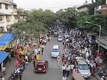 Chembur Market
Chembur (Marathi: चेंबूर) is a suburban neighbourhood in eastern Mumbai, India. It is 22 km from downtown Mumbai and 20 km from Chhatrapati Shivaji International Airport. Chemburkar (Marathi: चेंबूरकर) is the Marathi word to signify a resident of Chembur.
Contents
Toponymy
The name Chembur is probably derived from the word “Chimboree” which means "Large Crab" in Marathi.
History
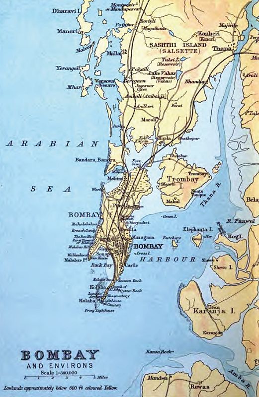
Before reclamation, Chembur lay on the North-Western corner of Trombay Island. It is suggested that Chembur is the same place referred to as Saimur by the Arab writers (915–1137), Sibor in Kosmas Indikopleustes (535), Chemula in the Kanheri cave inscriptions (300–500), Symulla by the author of the Periplus of the Erythraean sea (247), Symulla or Timulla by Ptolemy (150), and perhaps even Perimula by Pliny (A.D. 77).[1] This is however disputed and is also said to be a reference to Chevul at the mouth of the Kundalika River on mainland Maharashtra. Later the area occupied is said to have occupied a branch of an animal home. The home had on an average from 800 to 1000 animals a year - cows, bullocks, buffaloes, horses, ponies, donkeys, deer, goats, pigs, dogs, monkeys, cats and hares; and of birds, parrots, fowls, geese, duck, pigeons, crows and peacocks.[1]
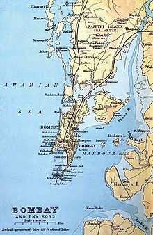 1893 map showing Chembur in the North-West of Trombay Island
The Bombay Presidency Golf Club was established in 1827 and was later re-built to meet international standards.[2] No further activity was seen until the Kurla-Chembur single railway line was built in 1906 for garbage trains. This railway line was opened to passenger traffic in the year 1924.[3] After construction activity in the 1920s, Chembur was finally opened up in the 1930s. It was made part of Greater Bombay in 1945.[4]
After independence, Chembur was one of the sites where refugee camps were set up to settle refugees after partition.[5] The industrialisation of Trombay during and after the war led to the demand for housing and the growth of Chembur thereafter.[6] The increased industrial activity around Chembur as well as garbage incinerators in proximity also raised the level of air pollution in the neighbourhood, earning it the nickname of "Gas Chamber of Mumbai".[7][8]
The construction by the Bombay Housing Board in Station Colony (Subash Nagar), the Shell Colony (Sahakar Nagar), and the Township Colony (Tilak Nagar) in 1955–58 transformed the area completely by shifting it from an industrial suburb to a residential one.[9]
Administration
Chembur lies in the Mumbai South Central parliamentary constituency. It used to lie in Mumbai North-East Parliamentary constituency prior to delimitation in 2008. After delimitation, it has been moved to Mumbai South Central parliamentary Constituency.[10] The Current sitting Member of Parliament of Mumbai South Central is Eknath Gaikwad (INC).[11]
Current sitting Member of Legislative Assembly are Mr. Chandrakant Handore and Mr. Nawab Malik. Chembur is also the seat of the M Ward Offices. The M Ward ranges from Thane Creek in East to Tansa Pipe Line No. 2 in West, from Somaiyya Nalla in North to Mahul Creek in South.[12][13] Chembur lies in ward numbers 141 to 149 with Councillors for each representing it in the Brihanmumbai Municipal Corporation.[14]
Geography
Chembur is surrounded by neighbouring suburbs such as Kurla, Deonar, Mahul, Govandi, Chunabhatti and Ghatkopar. Marine alluvium type of soil is observed in Chembur. It has North-South running basalt hills to its South.[15]
Transportation
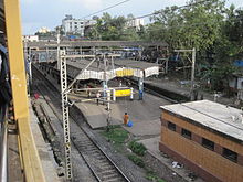 Chembur Railway Station seen from the CST end
Autorickshaws, taxis and BEST buses and trains are the public modes of transport available in Chembur. A monorail line and a metro is also to come up in the near future.
Dayanand Saraswati Marg, V N Purav Marg, R C Marg, Station Avenue Road while the Eastern Express Highway and Sion Panvel Highway are some of the arterial roads of Chembur. It is an important road transit point for people traveling to Pune using the Mumbai-Pune Highway or the Mumbai-Pune Expressway.
Chembur and Tilak Nagar Harbour Line railway stations lie in Chembur. The Lokmanya Tilak Terminus for long distance trains is also located here.
Economy
Chembur is home to several industries and also has several retail outlets.
The Chembur Market area close to the Chembur Railway Station offers a variety of goods and services to the people of Chembur ranging from clothing to foods and vegetables. In addition it has several retail and factory outlets, multi-product stores and a shopping mall. Chembur offers a large variety of food ranging from street food to high end restaurants.
Recreation
Chembur has several open public spaces like Gandhi Maidan, Annabhau Sathe Garden, Diamond Garden, Ambedkar Udyan, Sandu Garden, Tilak Nagar grounds (Sahyadri & Municipal Ground) and Jawahar Grounds where people meet up and conduct sports events and activities. These are also sites of recreational activity in the morning.
Bombay Presidency Golf Club at Dr Choitram Gidwani Road in Chembur (East) is one of the most prominent golf clubs in Mumbai, which also provides the biggest green cover for this neighbourhood. Chembur has various recreational clubs along with several Gymkhanas. Chembur also has several fitness centres and gyms, Municipal Swimming Pools, libraries etc. Some grounds have also added jogging tracks around them for people to exercise.
Environmental Problems
Chembur has been facing pollution problems and was recently ranked 46th in a list of the most polluted industrial clusters in India.[16] Studies in Chembur has also found high levels of Copper, Chromium, Calcium, Arsenic and Mercury in ground water.[15] Effluents from oil refineries, fertilizer plants and reactors located in Chembur are also said to have polluted sea water in Thane Creek and affected marine life.[15] The main problem is the uncontrolled release of ammonia and nitrous oxides from the Rastriya chemical fertiliser complex. Although ammonia is easy to scrub, the problem seems to be due to improper operation of pollution control equipment and/or operation of the urea/ammonia complex way beyond the design capacity without augmentation of pollution control equipment. Measurement of ammonia /nox levels is the best way to establish this by constant ambient air analysis.
See also
- Chembur (Vidhan Sabha constituency)
- Lokmanya Tilak High School
- Our Lady of Perpetual Succour High School
- Chembur Karnatak High School
- R.K. Studios
- Holy Family High School , Pestom Sagar ,Chembur
Footnotes
- ^ a b http://www.maharashtra.gov.in/pdf/gazeetter_reprint/Thane-III/places_Chembur.html
- ^ Times of India - Chembur Ghatkopar Plus - http://chemburghatkoparplus.mumbaimirror.com/index.aspx?Page=article&comments=true§name=Entertainment§id=10&contentid=2007101320071012141919203eb32847e - Retrieved on December 3, 2010
- ^ "History of Railways in India - Part 3". IRFCA. http://www.irfca.org/faq/faq-history3.html. Retrieved May 15, 2010.
- ^ TIFR Mumbai pages - http://theory.tifr.res.in/bombay/physical/geo/ghatkopar.html - Retrieved on December 5, 2010
- ^ Indian Express - http://www.indianexpress.com/ie/daily/19980926/26950934.html - Retrieved on December 3, 2010
- ^ TIFR Mumbai Pages - http://theory.tifr.res.in/bombay/physical/geo/mankhurd.html
- ^ http://www.indianexpress.com/res/web/pIe/ie/daily/19981215/34950814.html
- ^ http://www.dnaindia.com/mumbai/report_disaster-is-around-the-corner-for-mumbai_1327579
- ^ "History of Chembur". http://chemburhistory.googlepages.com/.
- ^ "Delimitation of Parliamentary and Assembly Constituencies Order - 2008". http://www.eci.gov.in/CurrentElections/CONSOLIDATED_ORDER%20_ECI%20.pdf.
- ^ "Sitting Members of the Lok Sabha". http://164.100.47.134/newls/sittingmember.aspx.
- ^ "M West limits". http://www.mcgm.gov.in/irj/portal/anonymous/qlwardmw.
- ^ "M East limits(includes Mankhurd and Govandi - excluded here)". http://www.mcgm.gov.in/irj/portal/anonymous/qlwardme.
- ^ "MCGM Councillors list". http://www.mcgm.gov.in/irj/portal/anonymous/qlcouncillors.
- ^ a b c Central Ground Water Board Report - Ground Water Information 2009 - http://cgwb.gov.in/District_Profile/Maharashtra/Greater%20Mumbai.pdf - Accessed on January 20, 2011
- ^ Gyan Varma (December 25, 2009) "43 Industrial Clusters imperiled in India", Daily News and Analysis. Accessed on January 25, 2011
External links
- Emergency Numbers
- BEST public buses route search
- CST/Panvel Train timetable
Chembur Next station south:
Tilak Nagar (Mumbai)Mumbai Suburban Railway : Harbour Line Next station north:
GovandiStop No: 13 KM from starting: 18 Platforms: 2 Stations on the Harbour Line of Mumbai Suburban Railway C.S.T - Andheri Route Chatrapati Shivaji Terminus · Masjid · Sandhurst Road · Dockyard Road · Reay Road · Cotton Green · Sewri · Vadala Road · King's Circle · Mahim · Bandra · Khar Road · Santacruz · Vile Parle · AndheriC.S.T - Panvel Route Chatrapati Shivaji Terminus · Masjid · Sandhurst Road · Dockyard Road · Reay Road · Cotton Green · Sewri · Vadala Road · Guru Tegh Bahadur Nagar · Chunabhatti · Kurla · Tilak Nagar · Chembur · Govandi · Mankhurd · Vashi · Sanpada · Juinagar · Nerul · Seawoods · C.B.D. Belapur · Khargar · Mansarovar · Khandeshwar · PanvelThane - Vashi Route Thane - Nerul Route Categories:- Railway stations in Mumbai
- Suburbs of Mumbai
-


Wikimedia Foundation. 2010.