- Chigwell
-
For the Hobart suburb, see Chigwell, Tasmania.
Coordinates: 51°37′21″N 0°04′20″E / 51.6225°N 0.07227°E
Chigwell 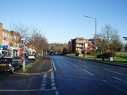
 Chigwell
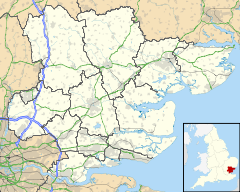
Chigwell shown within EssexPopulation 12,449 [1] OS grid reference TQ435935 Parish Chigwell District Epping Forest Shire county Essex Region East Country England Sovereign state United Kingdom Post town CHIGWELL Postcode district IG7 Dialling code 020 Police Essex Fire Essex Ambulance East of England EU Parliament East of England UK Parliament Epping Forest List of places: UK • England • Essex Chigwell is a civil parish and town in the Epping Forest district of Essex. It is located 11.6 miles (18.7 km) north east of Charing Cross. It is served by two London Underground stations and has a London (020) area code.
Contents
Etymology
According to P. H. Reaney's Place-Names of Essex, the standard guide to etymology in the county, the name means 'Cicca's well', Cicca being an Anglo-Saxon personal name. In medieval sources the name appears with a wide variety of spellings including "Cinghe uuella"[2] and Chikewelle". Folk etymology has sought to derive the name from a lost 'king's well', supposed to have been to the south-east of the parish near the border of what is now the London Borough of Redbridge. There were several medicinal springs in Chigwell Row documented by Miller Christy in his book History of the mineral waters and medicinal springs of the county of Essex, published in 1910. The proposal by 18th-century local historian Nathaniel Salmon that the "-well" element in the name derives from Anglo-Saxon weald (forest), indicating Chigwell's location in a royal demesne[2] rather than Anglo-Saxon wielle (well) has long been superseded by modern onomastic study and is no longer credible.
History
Traditionally a rural farming community, but now largely suburban, Chigwell was mentioned in the Domesday Book and later lauded by Charles Dickens in the novel Barnaby Rudge: A Tale of the Riots of 'Eighty; the Maypole Inn is based on the King's Head inn, though the name was taken from the Maypole public house in Chigwell Row; and it is likely Dickens visited both hostelries. Charles Dickens frequently visited Chigwell, which he described in a letter as "the greatest place in the world...Such a delicious old inn opposite the church...such beautiful forest scenery...such an out of the way rural place!".
From 1933 to 1974 Chigwell formed together with Buckhurst Hill and Loughton the Chigwell Urban District. Parish councils were re-established for the parishes of Buckhurst Hill, Chigwell, and Loughton in 1996.
A small area of the original parish was attached to London Borough of Redbridge when it was created in 1965; this area is now known as the Manford estate which still uses the Chigwell area name and postcode.
The hamlet of Chigwell Row lies towards the east of Chigwell near Lambourne; this part of the parish is well forested and mostly rural.
Grange Hill is the area around the junction of Manor Road and Fencepiece Road/Hainault Road, extending as far as the boundary with Redbridge including the Limes Farm estate.
RAF Chigwell
From 1933 to 1958 there was an RAF presence[3] based at Roding Valley Meadows (near what is now the David Lloyd Leisure Centre). It served first to provide barrage balloon protection during the Second World War and was involved in the rollout of Britain's coastal nuclear early warning system during the Cold War. In 1953 it briefly housed the RAF contingent taking part in the Coronation celebrations. Some of the RAF Chigwell site is now part of a local nature reserve.
Property
Chigwell has a population of around 12,500 and is generally considered a wealthy area,[4] which since the TV series Essex Wives, journalists have called (with Loughton and Buckhurst Hill), the Essex golden triangle. The area is characterised by large suburban houses, notably in Manor Road, Hainault Road and Chigwell High Road, which featured in the popular English situation comedy Birds of a Feather (although many of the outside locations used in that programme were not in Chigwell).
Education
 Chigwell School c. 1904
Schools in the area include Chigwell Primary School, Limes Farm Infants & Junior School, West Hatch High School and most notably Chigwell School, a public school, which was founded from a bequest by Samuel Harsnett, Archbishop of York, in 1629, among whose many famous past pupils are William Penn, who later went on to found Pennsylvania, and actor Sir Ian Holm.[4] The diarist John Aubrey recorded that it was at Chigwell School that Penn had a mystical vision, which influenced his later conversion to Quakerism. The original 17th-century schoolroom where Penn was taught still stands, and is now the school library.
Sport and leisure
Tottenham Hotspur football club has its training facilities in the area,[4] and runs training sessions for local youth on the Limes Farm estate through the summer months. Many past and present players and staff have homes in the area. Leyton Orient Football Club also have a training ground in Chigwell, adjacent to Chigwell School's fields.[4]
A David Lloyd Leisure Centre is situated off Roding Road by the M11 motorway, which offers indoor and outdoor tennis courts, swimming pools and gymnasium. Also in the area are a Holmes Place Health Club, Top Golf playing Centre and Chigwell Golf Club. Chigwell Cricket Club is based at the Old Chigwellians Club in Roding Lane. The town is also included in a number of London loop walks, which start in the city and passes through the outskirts of the capital.[4]
There are two pubs, The King William IV and Ye Olde King's Head ([5]) , which is said to be the Maypole Inn in Dickens' Barnaby Rudge.[4]
There is a local nature reserve at Roding Valley Meadows [1] off Roding Lane which follows the River Roding up to Loughton.
Transport
Bus
All bus services are TfL services, except route X5 and school routes 43, 804. Routes 150 and X5 only serve Chigwell Row. Routes 362 and 462 only serve Grange Hill.
 Chigwell Station, opened 1903 by the Great Eastern Railway
London Underground
Chigwell is served by Chigwell station and Grange Hill station (further south bordering Hainault), both on the Central line of the London Underground. For a more frequent service to London there is also nearby Buckhurst Hill, Loughton and Hainault stations since services between Grange Hill and Woodford are limited, most terminating at Hainault.
Famous residents
- Ilan Araujo Dall'Igna, footballer
- David Bentley, footballer
- Roy Carroll, footballer
- Ashley Cole, footballer
- Alan Davies, actor and comedian
- Jermain Defoe, footballer
- Paolo Di Canio, footballer
- Heurelho Gomes, footballer
- Katie Griffiths , actress, Clo Granger in Waterloo Road, born in Chigwell
- Sally Gunnell, athlete, pupil at West Hatch High School
- Admiral Sir Eliab Harvey, Royal Navy officer, lived at Rolls (demolished 1953)
- Simon Harris, music producer
- Tim Howard, footballer
- Geoff Hurst, footballer
- Harriet King, Victorian poet
- Don Lewin, owner of Clinton Cards
- Gary Lucy, actor, PC Will Fletcher in The Bill
- Bobby Moore, footballer, captain of the 1966 FIFA World Cup-winning England team
- Lucas Neill, footballer
- Ronnie O'Sullivan, snooker player
- Mark Wright, Reality TV star, Deuces club owner
- John Paintsil, footballer
- Kimi Räikkönen, racing driver
- Sergei Rebrov, footballer
- Teddy Sheringham, footballer
- George Shillibeer, creator of the London megabus, buried at St. Mary's, the parish church
- Kate Silverton, BBC newsreader, pupil at West Hatch High School
- Alan Sugar,[6] entrepreneur, former owner of Amstrad, host of The Apprentice
- Adel Taarabt, footballer
- Didier Zokora, footballer
- Sandro Raniere, footballer
See also
References
- ^ "Parish Profile: Chigwell". Epping Forest District Council. 2006. http://www.eppingforestdc.gov.uk/council_services/planning/census/chigwell.asp. Retrieved 2009-01-18.[dead link]
- ^ a b http://www.british-history.ac.uk/report.aspx?compid=45468
- ^ Roding Valley Meadows - RAF Chigwell Epping Forest District Council
- ^ a b c d e f Case, Hayden (September 2008). "What is it like to live in... Chigwell". Essex Life (Archant): pp. 30. http://edition.pagesuite-professional.co.uk/Launch.aspx?referral=other&pnum=&refresh=Xx310Ki2Lg80&EID=ae1ff680-f48b-4a38-9931-2ac69df9011d&skip=true. Retrieved 2009-01-18. (Registration required).
- ^ owned by local resident Lord Sugar
- ^ "In the line of fire". London: The Times. 2006-03-26. http://www.timesonline.co.uk/tol/life_and_style/article742101.ece. Retrieved 2008-07-06.
External links
The District of Epping Forest Parishes Abbess Beauchamp and Berners Roding • Bobbingworth • Buckhurst Hill • Chigwell • Epping • Epping Upland • Epping Green • Fyfield • High Laver and Little Laver • High Ongar • Lambourne • Loughton • Magdalen Laver • Matching • Matching Green • Matching Tye • Moreton • Nazeing • North Weald Bassett • Chipping Ongar • High Ongar • Roydon • Sheering • Stanford Rivers • Stapleford Abbotts • Stapleford Tawney • Theydon Bois • Theydon Garnon • Theydon Mount • Waltham Abbey • WillingaleAttractions Constituencies Section 19: London Outer Orbital Path Section 20: Chingford Chigwell Havering-atte-Bower Categories:- Civil parishes in Essex
- Towns in Essex
- Epping Forest
- London Loop


Wikimedia Foundation. 2010.