- Putumayo Department
-
"Putumayo" redirects here. For other uses, see Putumayo (disambiguation).
Department of Putumayo
Departamento del Putumayo— Department — 
FlagPutumayo shown in red
Coordinates: 1°09′N 76°37′W / 1.15°N 76.617°WCoordinates: 1°09′N 76°37′W / 1.15°N 76.617°W Country  Colombia
Region Amazonía Region Established 1991 (political) Mocoa Government – Governor Julio Byron Viveros Cháves (2010-) Area – Total 24,885 km2 (9,608.2 sq mi) Area rank 16 Population (2005)[1] – Total 299,286 – Rank 25 – Density 12/km2 (31.1/sq mi) Time zone UTC-05 ISO 3166 code CO-PUT Provinces Municipalities 13 Website www.putumayo.gov.co Putumayo is a department of Colombia. It is in the south-west of the country, bordering Ecuador and Peru. Its capital is Mocoa.
The word putumayo comes from the Quechua language. The verb putuy means "to spring forth" or "to burst out", and mayo is a variant of mayu, meaning river. Thus it means "gushing river".
Contents
Municipalities
Municipalities Map 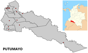
History
Originally, the south west of the department was territory of the Cofán Indians, the north west of the Kamentxá Indians, and the center and south belong to tribes that spoke Tukano languages (such as the Siona), and the east to tribes that spoke Witoto languages. Part of the Kamentxá territory was conquered by the Inca Huayna Cápac in 1492, who after crossing the Cofán territory, established a Quechua population on the valley of Sibundoy, that is known today as Ingas. After the Inca defeat in 1533, the region was invaded by the Spanish in 1542 and since 1547 administered by catholic missions.
The current territory of Putumayo was linked to Popayan during the Spanish Colony and on the firsts Republican decades belonged to the huge "Department of Asuay, that included territories in Ecuador and Perú. Later starts a ling process of territorial redistributions:
- 1831: Province of Popayán.
- 1857: Estado Federal del Cauca.
- 1886: Departament of Cauca.
- 1905: Intendencia del Putumayo.
- 1909: Intendencia del Caquetá.
- 1912: Comisaría Especial del Putumayo.
- 1953: Departament of Nariño.
- 1957: Comisaría Especial del Putumayo.
- 1968: Intendencia Especial del Putumayo.
- 1991: Departament of Putumayo.
A dark chapter in the history of Putumayo was the rubber fever, from the late 19th century until the 20th century. During this period, the Casa Arana enslaved and killed thousands of natives from Amazonia, these were used to extract natural rubber. Nowadays, however, a few native communities exist that withstood the Spanish colonization, the rubber exploitation, the recent oil extraction and the modern colonization.
References
External links
- (Spanish) Government of Putumayo official website
- (Spanish) Territorial-Environmental Information System of Colombian Amazon SIAT-AC website
Departments of Colombia  Categories:
- Putumayo Department
- Departments of Colombia
- States and territories established in 1991


Wikimedia Foundation. 2010.