- Crook Peak to Shute Shelve Hill
-
Crook Peak to Shute Shelve Hill Site of Special Scientific Interest 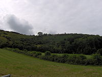
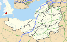
 Shown within Somerset
Area of Search Somerset Grid reference ST385555 Coordinates 51°17′43″N 2°52′53″W / 51.2952°N 2.8814°WCoordinates: 51°17′43″N 2°52′53″W / 51.2952°N 2.8814°W Interest Biological and Geological Area 332.2 hectares (3.322 km2; 1.283 sq mi) Notification 1952 Natural England website Crook Peak to Shute Shelve Hill (grid reference ST385555) to (grid reference ST430560) is a 332.2 hectare (820.9 acre) geological and biological Site of Special Scientific Interest near the western end of the Mendip Hills, Somerset, notified in 1952.
Contents
The site
The site extends for some 5 km from west to east. Near its eastern end it is divided by a gap used by the A38 road and the disused Cheddar Valley railway line. From west to east the site includes these hills:
- Crook Peak, reaching 191 metres (627 ft), a prominent feature from the surrounding landscape. Evidence of early human occupation includes a polished flint axe. A ridge to the south east of Crook Peak, known as 'The Razor', is used by the West Mendip Soaring Association to fly model aircraft in south-westerly / southerly or north-easterly winds.[1]
- Compton Hill, above the village of Compton Bishop
- Wavering Down, reaching a height of 211 metres (692 ft)
- Cross Plain, above the village of Cross
- Shute Shelve Hill, east of the A38 road, reaching a height of 233 metres (764 ft), above the town of Axbridge and adjoining Axbridge Hill and Fry's Hill
Most of the site is owned by the National Trust.
A long-distance footpath, the Mendip Way, follows much of the northern boundary of the site.
Etymology
Crook Peak has been important as a landmark and boundary from very early times, and the origins of the name are unclear. Some believe the name 'Crook' comes from Old British 'Cruc' meaning 'peak' or 'pointed hill'.[2][3]
Biological
 King's Wood between Cross Plain and Shute Shelve Hill is owned by the National Trust
This site comprises a wide range of habitats which includes ancient and secondary semi-natural broadleaved woodland, unimproved calcareous grassland and a complex mosaic of calcareous grassland and acidic dry dwarf-shrub heath. Four of the calcareous grassland communities, two of the woodland types and the calcareous grassland/acidic dry dwarf-shrub heath mosaic all have a restricted distribution in Britain. Four nationally rare and seven notable plant species are also present. Plants of interest include the nationally rare Cheddar Pink (Dianthus gratianopolitanus), Bedstraw (Galium fleurotii), Dwarf Sedge (Carex humilis) and Dwarf Mouse-ear (Cerastium pumilum). Rose Wood and King's Wood are ancient woodland sites. The nationally rare Purple Gromwell (Lithospermum purpurocaeruleum) occurs at Rose Wood.[4]
Geological
There are cave deposits of interest at the southern end of Crook Peak. Picken's Hole is of considerable importance because of its clear, well-stratified sequence of deposits and faunas, all dating from within the Devensian. The rich Layer 3 fauna, radiocarbon dated to 34,265 (+2600/–1950) years BP, includes Spotted Hyena, Lion, Arctic fox, Mammoth, Woolly Rhinoceros, horse, reindeer, suslik and Tundra Vole. The site is a major source of information for this phase of the Middle Devensian. It is also the most carefully excavated hyena-den site and assemblage from Britain.[4]
Shute Shelve Cavern is located on Shute Shelve Hill.
Barton Camp
Barton Camp, which is on the northern slopes of Crook Peak, is run by the Bristol Children's Help Society which was founded in 1884 to help needy children. The facilities include classrooms, a sports hall, outdoor pool, playing field and bunkhouse accommodation.[5]
References
- ^ "Crook Peak". West Mendip Soaring Association. http://www.slopesoaring.org.uk/wmsa/location.html. Retrieved 2006-07-17.
- ^ "Winscombe Parish". http://www.winscombeandsandfordpc.org.uk/wpchistory.php. Retrieved 2010-10-07.
- ^ "Not a soul in the West Mendips". Times Online (London). 2006-03-25. http://travel.timesonline.co.uk/article/0,,20489-2100264,00.html. Retrieved 2006-07-18.
- ^ a b "Crook Peak to Shute Shelve Hill". English Nature. http://www.english-nature.org.uk/citation/citation_photo/1001580.pdf. Retrieved 2006-07-17.
- ^ Steve Eggington (August 2006). "Serious Playtime". Mendip Times 2 (3): 10–11. http://www.mendiptimes.co.uk/.
Summary SSSIs Ben Knowle · Blue Anchor to Lilstock Coast · Brean Down · Brimble Pit and Cross Swallet Basins · Bruton Railway Cutting · Cheddar Complex · Cloford Quarry · Cook's Wood Quarry · Crook Peak to Shute Shelve Hill · Doulting Railway Cutting · Emborough Quarries · Glenthorne · Godminster Lane Quarry and Railway Cutting · Greylake · Ham Hill · Hobbs Quarry · Holwell Quarries · Hurcott Farm · Hurcott Lane Cutting · Lamb Leer · Langport Railway Cutting · Laycock Railway Cutting · Leighton Road Cutting · Low Ham · Maes Down · Maesbury Railway Cutting · Miller's Hill, Milborne Wick · Moon's Hill Quarry · Priddy Caves · Priddy Pools · Rodney Stoke SSSI · Sandpit Hole and Bishop's Lot · Seavington St Mary · Shepton Montague Railway Cutting · Snowdon Hill Quarry · St. Dunstan's Well Catchment · Thrupe Lane Swallet · Vallis Vale · Viaduct Quarry · Windsor Hill Quarry · Wookey Hole · Wookey Station · Wurt Pit and Devil's Punchbowl
Neighbouring areas Avon · Devon · Dorset · Wiltshire
Aller and Beer Woods · Aller Hill · Asham Wood · Axbridge Hill and Fry's Hill · Babcary Meadows · Barle Valley · Barrington Hill Meadows · Berrow Dunes · Black Down and Sampford Commons · Brean Down · Bridgwater Bay · Briggins Moor · Catcott, Edington and Chilton Moors · Chancellor's Farm · Cheddar Complex · Cheddar Reservoir · Cheddar Wood · Cleeve Hill · Cogley Wood · Crook Peak to Shute Shelve Hill · Curry and Hay Moors · Deadman · Draycott Sleights · Dunster Park and Heathlands · East Polden Grasslands · Ebbor Gorge · Edford Woods and Meadows · Exmoor Coastal Heaths · Fivehead Woods and Meadow · Freshmoor · Friar's Oven · Ge-mare Farm Fields · Great Breach and Copley Woods · Grove Farm · Hardington Moor · Hestercombe House · Holme Moor & Clean Moor · King's Sedgemoor · Kingdown and Middledown · Kingweston Meadows · Lang's Farm · Langford Heathfield · Langmead and Weston Level · Long Lye · Long Lye Meadow · Longleat Woods · Millwater · Moorlinch · Nettlecombe Park · North Brewham Meadows · North Curry Meadow · North Exmoor · North Moor · Old Ironstone Works, Mells · Perch · Porlock Ridge and Saltmarsh · Postlebury Wood · Priddy Pools · Prior's Park & Adcombe Wood · Quantock Hills · Quants · Ringdown · River Barle · Rodney Stoke · Roebuck Meadows · Ruttersleigh · Severn Estuary · Shapwick Heath · Sharpham Moor Plot · South Exmoor · Southey and Gotleigh Moors · Southlake Moor · Sparkford Wood · St. Dunstan's Well Catchment · Stowell Meadow · Street Heath · Tealham and Tadham Moors · Thurlbear Wood and Quarrylands · Twinhills Woods and Meadows · Vallis Vale · Walton and Ivythorn Hills · West Moor · West Sedgemoor · Westhay Heath · Westhay Moor · Wet Moor · Whitevine Meadows · Windsor Hill Marsh · Wookey Hole · Woolhayes FarmNeighbouring areas: Avon · Devon · Dorset · WiltshireCategories:- Mendip Hills
- Hills of Somerset
- National Trust properties in Somerset
- Sites of Special Scientific Interest in Somerset
- Sites of Special Scientific Interest notified in 1952


Wikimedia Foundation. 2010.