- Cogan, Vale of Glamorgan
-
Coordinates: 51°26′42″N 3°11′17″W / 51.445°N 3.188°W
Cogan 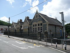
Cogan Primary School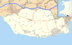
 Cogan
Cogan
Cogan shown within the Vale of GlamorganOS grid reference ST185715 Principal area Vale of Glamorgan Ceremonial county South Glamorgan Country Wales Sovereign state United Kingdom Post town PENARTH Postcode district CF64 Dialling code +44-29 Police South Wales Fire South Wales Ambulance Welsh EU Parliament Wales UK Parliament Cardiff South & Penarth List of places: UK • Wales • Vale of Glamorgan Cogan is a suburb of Penarth in the Vale of Glamorgan, Wales 4.5 miles (7.2 km) south west from the Welsh capital city of Cardiff. Cogan contains one of the vale's four major leisure centres.
Contents
History
 The corner houses with angled facings show where the many shops once stood, the angled wall once containing the shop entrance door
 "The Cogan" public house
 The Cogan general stores, a rare surviving local shop
Cogan Pill House is the oldest still standing house in the Penarth area having been built in 1554. It is now known as the Baron's Court Restaurant.
Just two hundred years ago Cogan was a small village of a few scattered houses and farms within the Hundred of Dinas Powys. In 1875 Cogan was reallocated to the new Penarth Local Board in a major administrative reorganisation. The building of Penarth Docks in 1865 and the town's rapid growth prompted an explosion of house building in Cogan providing mostly terraced housing, local shops and public houses for dock workers. Most of the building in the village took place over the ten years between 1859 and 1869 and Cogan contained two busy brickworks, making the local marl bricks still seen today all over Cogan and Penarth.
The majority of the many small local Cogan shops, butcher, baker, greengrocer, hardware store, chemist, barbers, newsagents and general grocery shops located on Windsor Road, down Pill Street and on almost all of the street corners in the village had been closed by the early 1950s and converted to residential housing, these ex shops being identified by the angled corner facings where the shop entrance doors used to be. Since Cogan's Post Office on Pill Street closed in April 2008, only a taxi control office, a ladies hairdressers, a Chinese fast food takeaway and a sole surviving general store, and in March 2011 a new addition of a sandwich bar remain.
Cogan railway station is located on the Vale of Glamorgan Line and provides services to Barry, Rhoose, Bridgend and Cardiff. Until 1968 Cogan had two further platforms across the other side of the main Windsor Road and located on the Penarth and Sully branch line, from the Cogan Junction points down the coastline to where it rejoined the main line at Cadoxton. The through link was closed under the effects of the Beeching Axe and the rail spur now terminates at Penarth. Dingle Road Halt and Penarth station remain open but the platforms at Cogan were closed when the line was reduced to a single track branchline. Most of the station buildings still stand and have been used by several private businesses including a shooting range, a garden centre, a second hand car lot and a marine chandlers. The area originally covered by the Cogan and Penarth Dock's railway sidings and engine maintenance sheds now contains a large Tesco supermarket.
Cogan used to be connected to Llandough by Andrew Road which is now closed off to all but public buses. Conversely Pill Street was a dead end until the 1970s when a connection was driven through, up the slope to the newly built Cowslip Estate housing development. Apart from the addition of a street to the garden village in the 90's, no new housing built in the village since the early 1970s when the Cogan Garden Village was completed, on the site of the main Penarth brickmakers and any further housebuilding is prevented through lack of space to develop; The village is bounded on two sides by the railway tracks, by the Cowslip slope on another and by the Poets Estate on the fourth side. The only land now not built on is the sports fields attached to the Penarth Leisure Centre, land that originally formed the common land of the village green where small holders grazed their animals in medieval times.
Education
 Hebron Church, Pill Street
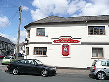 Cogan Coronation Club
The only school in Cogan is Cogan Primary School in Pill Street, administered by the Vale of Glamorgan Local Education Authority. It is a Mixed school of non-denominational religion. The school building is a well maintained Victorian structure.
Religious sites
Hebron Methodist Church, a place of worship since 1904, is on Pill Street.
Sport
Penarth's premier football club is located in Cogan and forms part of Cogan Coronation Sports Club, playing their games at the Leisure Centre's playing fields. Cogan Coronation AFC's first team, known locally as "The Coro" plays in the South Wales F.A. Senior League 1st Division and the club fielded eighteen teams of all ages during the 2007/2008 season.
Cogan Leisure Centre, serving the community of Penarth is located within the village.
External links
- Penarth Leisure Centre
- Cogan Coronation AFC website
- Local history page
- 1860 Ordnance Survey map of Cogan
Categories:- Villages in the Vale of Glamorgan
- Populated coastal places in Wales


Wikimedia Foundation. 2010.